Kabini River
| Kabini | |
 Kabani River from Kabanigiri, Kerala | |
| Country | India |
|---|---|
| States | Kerala, Karnataka |
| Source | Panamaram |
| - location | Wayanad district, Kerala, India |
| - coordinates | 11°48′01″N 76°04′29″E / 11.80028°N 76.07472°E |
| Mouth | Tirumakudal Narsipur |
| - location | Mysore district, Karnataka, India |
| - coordinates | 12°12′56″N 76°54′40″E / 12.21556°N 76.91111°ECoordinates: 12°12′56″N 76°54′40″E / 12.21556°N 76.91111°E |
The Kabani, also called Kabini or Kapila, is one of the major tributaries of the river Cauvery in southern India.[1] It originates in the Wayanad District of Kerala state by the confluence of the Panamaram River and the Mananthavady River. It flows eastward to join the Kaveri River at Tirumakudalu Narasipura in Karnataka.
Close to the town of Sargur it forms the huge Kabini Reservoir.[2] The backwaters of the Kabini reservoir are very rich in wildlife especially in summer when the water level recedes to form rich grassy meadows. The Kabini dam is 2,284 ft (696 m) in length with an original gross storage of 19.52 tmcft. The Kabini Dam is situated between villages Bichanahalli and Bidarahalli having distance of 17 km (11 mi) 6 km away from Sargur town in Heggadadevana kote taluk, Mysore district, Karnataka.
Wildlife
The Kabini Forest Reserve is one of the most popular wildlife destinations of Karnataka, probably because of its accessibility, lush green landscape surrounding a large lake, and sightings of herds of elephants, tigers. It is 80 km (50 mi) away from Mysuru and 205 km (127 mi) from Bengaluru, and comprises the south-eastern part of Nagarahole National Park. Situated on the banks of the Kabini River, the reserve is spread over 55 acres (22 ha) of forestland, steep valleys, and water bodies. Once a private hunting lodge of the Maharaja of Mysore, Kabini was a popular shikar hotspot for British Viceroys and Indian royalty. Now it is considered to be one of the best Wildlife National Parks in India, famous for its spectacular wildlife and bird life. There are around 120 tigers, 100+ leopards, Four types of deer, Sloth bear, Indian Gaurs and elephants in the Nagarahole National Park.
Course
The river originates in the Pakramthalam hills at Kuttiady-Mananthavady road. Makkiyad river and Periya river join it near Korome and Valad respectively. After flowing through Mananthavady town, Panamaram river joins Kabini near Payyampally. One branch of the Panamaram river starts from the Banasura Sagar reservoir near Padinjarethara and the other branch of the river start from Lakkidi hills. After traversing 2 kilometres (1.2 mi) from the confluence of Panamaram river Kabini forms an island called Kuruva Island, spreading over 520 acres (2.1 km2) with diverse flora and fauna. Within 20 km (12 mi) it reaches the Kabini reservoir bordering Kerala and Karnataka for some distance. Between Kabani reservoir and Kuruva island Kalindi river joins Kabini. Kalindi river originates from Brahmagiri hills which on reaching near Thirunelli Temple the rivulet Papanasini joins it. Taraka and Nugu are the two small rivers in Heggadadevana kote taluk that join the Kapila (Kabani river).
Kabini dam
| Kabini dam | |
|---|---|
 | |
| Coordinates | 11°58′25″N 76°21′10″E / 11.9735°N 76.3528°E |
| Dam and spillways | |
| Type of dam | Earthen Dam with Left Bank spillway |
| Impounds | Kabini River |
| Height | 166 ft. above River Bed Level |
| Length | 12,927 ft. |
The Kabini dam is built on the River Kabini in the district of Mysore. The dam is 696 meters in length and was built in 1974. The exact location of the dam is near village Beechanahally, in Taluk Heggadadevanakote. The catchment area of the dam is 2,141.90 km2. It caters to the needs of around 22 villages and 14 hamlets and also a prominent source of drinking water to Bengaluru. Further significant amount of water is discharged to the Mettur reservoir in Tamilnadu to fulfill the state's needs.
This dam also provides water to the combined system of Sagaredoddakere and Upper Nugu Dams. There is an arrangement of lifting and transfer of 28.00 TMC of water during the monsoons months from the Kabini dam to the other two smaller dams. The dam is spread over an area of 55 hectares covering forests, rivers, lakes and valleys.
Image gallery
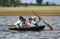 Indian coracles are used on the Kabini River
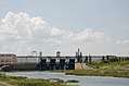 Kabini reservoir
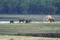 Elephant family on the Kabini River bank
 Kabani river at Sujathapuram
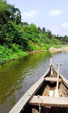 Marakkadavu ferry on Kabani river
References
| Wikimedia Commons has media related to Kabini River. |