Chottanikkara
| Chottanikkara ചോറ്റാനിക്കര | |
|---|---|
| village | |
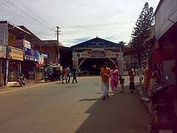 West Nada, Chottanikkara Temple | |
 Chottanikkara Location in Kerala, India  Chottanikkara Chottanikkara (India) | |
| Coordinates: 9°55′59″N 76°23′28″E / 9.933°N 76.391°ECoordinates: 9°55′59″N 76°23′28″E / 9.933°N 76.391°E | |
| Country |
|
| State | Kerala |
| District | Ernakulam |
| Languages | |
| • Official | Malayalam, English |
| Time zone | UTC+5:30 (IST) |
| Vehicle registration | KL-39 |
| Nearest city | Tripunithura |
Chottanikkara (Malayalam: ചോറ്റാനിക്കര) is a southern suburb of the city of Kochi, Kerala, India. In local administration, it is a panchayat which consists of Chottanikkara, Kanayannur, Eruvely, Kureekkad, Vattukkunnu, Palace Square and Kottayathupara. Chottanikkara is also a part of urban agglomeration of City of Cochin.
The famous Chottanikkara temple is situated in this town.[1] Kochi city buses are directly connected to Chottanikkara. Chottanikkara Government school Stadium is one of the largest Stadiums in Ernakulam District.Shooting spot on Eruveli Pallippurathu mana Chottanikara panchayath was decided as the best panchayath.[2]
Location
| |||||||||||||
References
| Wikimedia Commons has media related to Chottanikkara. |
- ↑ Chottanikkara temple site, retrieved 9 May 2014
- ↑ "ethavum mikacha jilla panchayath". k vartha. 6 April 2013. Retrieved 12 April 2013.
This article is issued from
Wikipedia.
The text is licensed under Creative Commons - Attribution - Sharealike.
Additional terms may apply for the media files.