Kilimanoor
- This article is about Kilimanoor Town. For the assembly constituency, see Kilimanoor Assembly Constituency. For the block panchayat, see Kilimanoor Block Panchayat.
| Kilimanoor | |
|---|---|
| Village | |
 Kilimanoor Nadakashala | |
| Coordinates: 8°46′01″N 76°52′48″E / 8.767°N 76.88°ECoordinates: 8°46′01″N 76°52′48″E / 8.767°N 76.88°E | |
| Country |
|
| State | Kerala |
| District | Thiruvananthapuram |
| Government | |
| • Type | Local Self Government |
| • Body | Pazhayakunnummel Grama Panchayat & kilimanoor grama panchayat |
| Area | |
| • Total | 44.35 km2 (17.12 sq mi) |
| Population (2011) | |
| • Total | 45,523 |
| Languages | |
| • Official | Malayalam, English |
| Time zone | UTC+5:30 (IST) |
| PIN | 695601 |
| Telephone code | 0470 |
| Vehicle registration | KLT, KLV, KRT, KRV, KET, KEV, KBT, KBV, KL-01/KL16 |
| Civic agency | Pazhayakunnummel Grama Panchayat & kilimanoor grama panchayat |
| The details are for Kilimanoor Town | |
Kilimanoor is a census town in the state of Kerala, India. It is located on MC/SH 1 Road, 36 kilometres (22 mi) from the city of Thiruvananthapuram (Trivandrum). The town area is administered by two grama panchayats, Pazhayakunnummel and Kilimanoor grama panchayat. Kilimanoor town is an important business centre and one of the potential fast-growing towns in south Kerala. Kilimanoor is looking forward to become a municipality.
History
Kilimanoor ("land of the bird and the deer") was ruled by a Pillai ruling chief and was forfeited to Travancore by Maharaja Marthanda Varma. The estate comprising several villages was then handed over to the family of the father of the King who had come south from Parappanad in Malabar around 1718. [1]was ruled by a tribal chief during time of the Ettuveetil Pillamar in the kingdom of Travancore. The chief rebelled against the Maharajah Marthanda Varma, and the region was annexed and later given to the Royal House of Kilimanoor.[2]
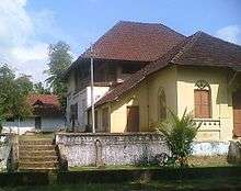
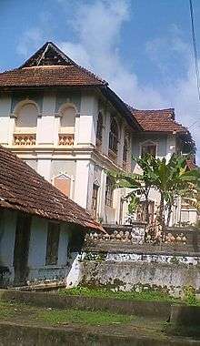
This Royal House of Kilimanoor has a history of more than 300 years. In 1705 (ME 880), the son and two daughters of Ittammar Raja of Beypore Thattarikovilakam, a Kolathunadu royal house, were adopted by the Royal house of Venad. Ittammar Raja's sister and her sons, Rama Varma and Raghava Varma, settled in Kilimanoor and married the now-adopted sisters. Marthanda Varma, the founder of the Kingdom of Travancore was the son of Raghava Varma. Raghava Varma's nephew, Ravi Varma Koil Thampuran, married Marthanda Varma's sister. Their son came to be known as Dharma Raja Kartika Thirunnal Rama Varma. In 1740, when an allied force led by Dutch Captain Hockert supporting the Deshinganadu king attacked Venad, an army from Kilimanoor tactfully resisted and then defeated them. Although a small victory, this was the first time an Indian army defeated a European power. In recognition of this feat, Marthanda Varma, in 1753, exempted the areas under control of Kilimanoor Palace from taxes and proclaimed autonomous status. The present palace complex was also built during this time along with the Ayyappa temple for the family deity.
Velu Thampi Dalawa held meetings at the Kilimanoor Palace, planning his revolts against the British. He handed over his sword at the palace before going for his final battle against the British. India's First President, Dr. Rajendra Prasad received the sword from the palace, and it is now kept at the National Museum, New Delhi.Subsequently placed at the Napier Museum in the capital city of Kerala.
Politics
The Communist Party of India (Marxist) (CPI(M)) and Communist Party of India (CPI) have a strong base. [Attingal Constituency]] (SC) is part of Attingal (Lok Sabha constituency).[3]
Geography
- Major towns around Kilimanoor
| ||||
Transportation
Kilimanoor is on the Main Central Road. It is connected to the whole major destination by buses run by Kerala State Road Transport Corporation from the Kilimanoor bus depot. Kilimanoor is only 38 kilometres (24 mi) away from Thiruvananthapuram. The nearest airport is Trivandrum International Airport. The nearest rail is varkala shivagiri.
Notable residents
- Raja Ravi Varma
- Raja Raja Varma
- Kilimanoor Chandran
- Kilimanoor Ramakanthan
- Kilimanoor R Thyagarajan[4][5]
- Kilimanoor Raja Raja Varma Koithampuran
- Madavoor Vasudevan Nair
- Kilimanoor Madhu
- C. Raja Raja Varma
- Bijulal Babu
- Sithara
- JAGADEESH
- BIJUKUMAR BP
Educational Organizations
- N.S.S College, Nilamel.[6]
- Vidya Academy of Science And Technology, Kilimanoor.[7]
- Sree Shankara Vidyapeetom College, Nagaroor, Kilimanoor.[8]
- Rajadhani Institute of Engineering, Nagaroor, Kilimanoor.[9]
- Govt. higher secondary school, Kilimanoor
- Raja Ravi Varma vocational higher secondary school
- Raja Ravi Varma higher secondary school for girls
- Govt. higher secondary school, Thattathumala
- Maths Centre,puthiyakav,Kilimanoor
- BOSE AND RAJEEV KILIMANOOR
- M.G.M School, kilimanoor
- M.G.M Poly Technic, kilimanoor
- S.M.T Public School,Chenkikunnu,Kilimanoor
- Vidya Jyothi School,Pappala kilimanoor
- Mahatma Gandhi Memmorial School,Canara Kilimanoor
- Sisu Vihar (State syllabus) Puthiyakavu Kilimanoor
- Alpha Teachers Training School,Peroor,Kilimanoor
Tourist attractions
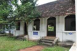
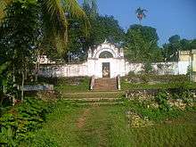
- Kilimanoor palace
- Raja Ravi Varma Art gallery[10]
- Jadayupara, Chadayamangalam[11]
- Meenmutti waterfalls (Tholikkuzhy)
- Thampurattippara
- Puthiyakavu Devi Kshethram, Kilimanoor.
- Mahadeveshwaram Mahadeva Kshethram, Kilimanoor.
- Irumoola Siva Temple, Valanchery
- Thirupalkadal Sreekrishnaswamy Temple
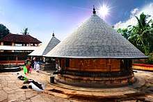 Thirupalkadal Sreekrishnaswamy Temple
 - Pazhayattumoozhy Sree Madan Thampuran Kshethram
- Alathukave Sree Subrahmanya Swami Kshetharm.
- Kizhakkedam Sree Dharmashastha Temple.
- Puthukulangara Sreedharma sastha kshetram, Pullayil.
- Holy Family Church, Karette, Kilimnoor.
- Kadamukku Madan Thampuran Temple
- Kadalukani para Karette
- Ganapathippara, kailasam, thattathumala
See also
Climate
| Climate data for Kilimanoor, Kerala | |||||||||||||
|---|---|---|---|---|---|---|---|---|---|---|---|---|---|
| Month | Jan | Feb | Mar | Apr | May | Jun | Jul | Aug | Sep | Oct | Nov | Dec | Year |
| Average high °C (°F) | 30.0 (86) |
30.9 (87.6) |
32.1 (89.8) |
32.1 (89.8) |
31.9 (89.4) |
29.7 (85.5) |
29.2 (84.6) |
29.6 (85.3) |
29.9 (85.8) |
29.7 (85.5) |
29.3 (84.7) |
29.4 (84.9) |
30.3 (86.6) |
| Average low °C (°F) | 22.5 (72.5) |
23.2 (73.8) |
24.6 (76.3) |
25.4 (77.7) |
25.5 (77.9) |
24.2 (75.6) |
23.7 (74.7) |
23.8 (74.8) |
23.9 (75) |
23.9 (75) |
23.5 (74.3) |
22.7 (72.9) |
23.9 (75) |
| Average precipitation mm (inches) | 21 (0.83) |
30 (1.18) |
56 (2.2) |
142 (5.59) |
218 (8.58) |
382 (15.04) |
295 (11.61) |
195 (7.68) |
184 (7.24) |
283 (11.14) |
207 (8.15) |
61 (2.4) |
2,074 (81.64) |
| Source: Climate-Data.org[12] | |||||||||||||
References
| Wikimedia Commons has media related to Kilimanoor. |
- ↑ (See page 4 in Madras Presidency Records, 1915, Supt , Government Press, Madras.)
- ↑ Aiya 1906, p. 329.
- ↑ "Assembly Constituencies — Corresponding Districts and Parliamentary Constituencies" (PDF). Kerala. Election Commission of India. Archived from the original (PDF) on 2009-03-04. Retrieved 2008-10-21.
- ↑ http://timesofindia.indiatimes.com/city/thiruvananthapuram/Disciples-celebrate-sapthathi-of-violinist-Kilimanoor-Thyagarajan/articleshow/46802919.cms
- ↑ http://www.newindianexpress.com/cities/thiruvananthapuram/Violin-Maestros-Birthday/2015/04/02/article2742020.ece
- ↑ http://www.nsscnilamel.org/
- ↑ http://vidyatcklmr.ac.in/
- ↑ http://www.sreesankaratrust.org/ssvk.htm
- ↑ http://riet.edu.in/
- ↑ http://www.newindianexpress.com/cities/thiruvananthapuram/Raja-Ravi-Varma-Art-Gallery-Opened/2014/11/20/article2531832.ece
- ↑ http://www.thehindubusinessline.com/news/jatayus-tale-comes-alive/article5723094.ece
- ↑ "CLIMATE: KILIMANOOR", Climate-Data.org. Web: .
- Bibliography
- Aiya, V. Nagam (1906). Travancore State Manual. Travancore Government Press.