Geological Survey of India
|
| |
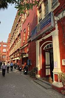 Central Headquarters. 27 JN Road, Kolkata. | |
| Agency overview | |
|---|---|
| Formed | 1851 |
| Jurisdiction |
British India (1851-1947) Republic of India (From 1947) |
| Headquarters | Kolkata |
| Agency executive |
|
| Website | https://www.gsi.gov.in/ |
The Geological Survey of India (GSI), founded in 1851, is a Government of India Ministry of Mines organisation, one of the oldest of such organisations in the world and the second oldest survey in India after Survey of India (founded in 1767), for conducting geological surveys and studies of India, and also as the prime provider of basic earth science information to government, industry and general public, as well as the official participant in steel, coal, metals, cement, power industries and international geoscientific forums.
GSI (geology) as well as ASI (archaeology), BSI (botany), FiSI (fisheries), FSI (forests), IIEE (ecology), NIO (oceanography), RGCCI (population survey) and language survey), SI (cartography), and ZSI (zoology) are key national survey organisations of India.
History
Formed in 1851 by East India Company, its roots can be traced to 1836 when the "Coal Committee", followed by more such committees, was formed to study and explore availability of coals in the eastern parts of India.[1][2] British colonised India for the systematic financial exploitation of resources,[3] leading to India's deindustrialization and Britain's Industrial Revolution,[4][5][6] by using India as both a significant supplier of raw goods to British manufacturers and a large captive market for British manufactured goods,[7] to sell British goods in India without any tariffs or duties and to heavily tax local Indian producers with the imposition of Britain protectionist policies such as bans and high tariffs to restrict Indian finished goods from being sold in Britain, whereas raw material was imported from India without tariffs to British factories,[8][9][10] resulting in decline of India's share of the world economy from 24.4% in 1700 to 4.2% in 1950,[11] decline of India's share of global industrial output from 25% in 1750 down to 2% in 1900,[12] and corresponding increase in United Kingdom's share of the world economy rose from 2.9% in 1700 up to 9% in 1870.[11][9] David Hiram Williams, one of the first surveyors for the British Geological Survey, was appointed 'Surveyor of coal districts and superintendent of coal works, Bengal' on 3 December 1845 and arrived in India the following February.[1][2] The phrase "Geological Survey of India" was first used on his Dec 1847 map of the Damoodah and Adji Great Coal Field,[13] together with Horizontal[14][15] and Vertical sections of the map.[16] On 4 February 1848, he was appointed the "Geological Surveyor of the Geological Survey of India", but he fell off his elephant and, soon after, died with his assistant, F. B. Jones, of 'jungle fever' on 15 November 1848,[17] after which John McClelland took over as the "Officiating Surveyor" until his retirement on 5 March 1851.[1][2]
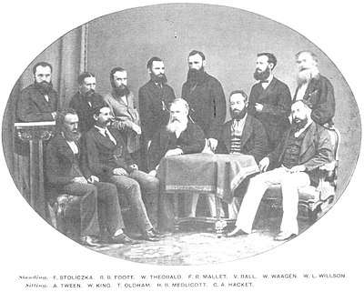
Until 1852, Geological Survey primarily remained focused on exploration for coal, mainly for powering steam transport, oil reserves, and ore deposits, when Sir Thomas Oldham, father of Richard Dixon Oldham, broadened the ambit of the scope of functioning of the Geological Survey of India by advancing the argument with the government that it was not possible to find coal without first mapping the geology of India. Thus, the Geological Survey commenced to map the rock types, geological structures and relative ages of different rock types . The age of rock strata was estimated from the presence of index fossils, which consumed much of the geologists' efforts in finding these index fossils, as the method of Radiometric dating for estimating the age of rock strata was not developed at that time.[1][2]
In 19th and early 20th century GSI made important contributions to Seismology by its studies and detailed reports on numerous Indian earthquakes. Richard Dixon Oldham, like his father also worked for GSI, first correctly identified p- and s-waves, and hypothesised and calculated the diameter of the Earth's core.[1][2]
On 8 April 2017 GSI began pilot project, with the first ever aerial survey of mineral stocks by GSI, to map the mineral stocks up to a depth of 20 km using specially-equipped aircraft.[18]
The GSI was restructured into 5 Missions, respectively relating to "Baseline Surveys";"Mineral resource Assessments";"Geoinformatics";"Multi-disciplinary Geosciences"; and "Training and Capacity Building", on the basis of the Report of a High-level Committee chaired by Mr S.Vijay Kumar[19] Additional Secretary in the Ministry of Mines of the Government of India.
The Superintendent and The Directors of GSI
| Sr. No. | Name | Period | Country |
|---|---|---|---|
| 1. | Dr. Thomas Oldham, The Superintendent | 1851–1876 | Dublin, Republic of Ireland |
| 2. | H. B. Medlicott, The Superintendent | 1876–1885 | Loughrea, County Galway, Ireland |
| 3. | H. B. Medlicott, The Director | 1885–1887 | Loughrea, County Galway, Ireland |
| 4. | William King Jr. | 1887–1894 | Ireland; an Anglo-Irish |
| 5. | C.L.Griesbach | 1894–1903 | Vienna, Austria |
| 6. | Sir T. H. Holland | 1903–1910 | Helston, Cornwall, England |
| 7. | Sir Henry. H. Hayden | 1910–1921 | Derry, Ireland |
| 8. | Sir Edwin Hall Pascoe | 1921–1932 | England |
| 9. | Sir L.L. Fermor | 1932–1935 | Peckham, south London, England |
| 10. | Dr. A. M. Heron | 1935–1939 | British, Duddingston, Edinburgh, Scotland |
| 11. | Dr. Cyril S. Fox | 1939–1943 | - |
| 12. | Dr. Edward Leslie Gilbert Clegg | 1943–1944 | Manchester, England |
| 13. | H. Crookshank | 1944–1945 | - |
| 14. | J.A. Dunn | 1945 | - |
| 15. | Dr. William Dixon West | 1945–1951 | Bournemouth, England |
| 16. | Dr. M. S. Krishnan, First Indian Director | 1951–1955 | Thanjavur, Tamil Nadu |
| 17. | V. P. Sondhi | 1955–1958 | - |
| 18. | Dr. B. C. Roy | 1958–1964 | - |
The Director General of GSI
| Sr. No. | Name | Period | Stream |
|---|---|---|---|
| 1. | Dr. B. C. Roy | 1964–1965 | Geology |
| 2. | R. A. G. Jhingran | 1965–1966 | Geology |
| 3. | G. C. Chatterji | 1966–1969 | Geology |
| 4. | M. S. Balasundaram | 1969–1972 | Geology |
| 5. | Dr. M. K. Roychoudhury | 1972–1974 | Geology |
| 6. | C. Karunakaran | 1974–1975 | Geology |
| 7. | Dr. V. K. S. Vardan | 1976–1977 | Geology |
| 8. | V. S. Krishnaswamy | 1978–1981 | Geology |
| 9. | J. Swami Nath | 1981–1982 | Geology |
| 10. | S. K. Mukherjee | 1982–1986 | Geology |
| 11. | D. P. Dhoundial | 1986–1990 | Geology |
| 12. | Dr. D. K. Roy | 1990–1991 | Geology |
| 13. | C. P. Vohra | 1991–1992 | Geology |
| 14. | S. N. Chaturvedi | 1992–1993 | Geology |
| 15. | D. B. Dimri | 1993–1996 | Geology |
| 16. | Dr. S. K. Acharya | 1996–2000 | Geology |
| 17. | K. Krishnanunni | 2000–2001 | Geology |
| 18. | Ravi Shankar (Acting) | 01.04.2001–30.11.2001 | Geology |
| 19. | P. C. Mondal | 2001–2004 | Geology |
| 20. | Dr. K. N. Mathur | 2004–2005 | Geology |
| 21. | Dr. M. K. Mukhopadhyay (Acting) | 01.10.2005–31.12.2005 | Geology |
| 22. | P. M. Tejale | 2006–2009 | Instrumentation |
| 23. | Dr. N. K. Dutta (Acting) | 2009–2010 | Geology |
| 24. | Jaswant Singh (Acting) | 2010–2011 | Engineering |
| 25. | A. Sundaramoorthy | 2011–2013 | Geology |
| 26. | Sisir Chandra Rath (Acting) | 01.11.2013–31.12.2013 | Geology |
| 27. | Dr. Sudesh Kumar Wadhawan (Acting) | 01.01.2014–31.07.2014 | Geology |
| 28. | Harbans Singh | 31.07.2014–30.05.2016 | Geology |
| 29. | M. Raju (Acting) | 01.06.2016–30.08.2017 | Geology |
| 30. | M. Raju | 30.08.2016–31.08.2017 | Geology |
| 31. | N. Kutumba Rao | 01.09.2017–31.05.2018 | Geology |
| 32. | Dr. Dinesh Gupta (Acting) | 01.06.2018–till date | Geophysics |
Geological parks
Some of the geological parks include Tiruvakkarai National Fossil Wood Park national geo-heritage site with wood fossils scattered over 247 acres nine separate enclaves, Sathanur National Fossil Wood Park national geo-heritage site with a 18-meter 120 million years old fossilised tree trunk from the Cretaceous period, Nehru Zoological Park at Hyderabad with life size figures of T-Rex and other dinosaurs, and Saketi Fossil Park near Chandigarh with a fossil museum and life size fiberglass models of six pre-historic animals.
See also
References
- 1 2 3 4 5 Kumar, Deepak (1982). "Economic Compulsions and the Geological Survey of India". Indian Journal of History of Science. 17 (2): 289–300.
- 1 2 3 4 5 Chakrabarty, S (2012). "Geological Survey of India". In Islam, Sirajul; Jamal, Ahmed A. Banglapedia: National Encyclopedia of Bangladesh (Second ed.). Asiatic Society of Bangladesh.
- ↑ Rajat Kanta Ray, "Indian Society and the Establishment of British Supremacy, 1765–1818," in The Oxford History of the British Empire: vol. 2, "The Eighteenth Century" ed. by P. J. Marshall, (1998), pp 508–29
- ↑ Junie T. Tong (2016), Finance and Society in 21st Century China: Chinese Culture Versus Western Markets, page 151, CRC Press
- ↑ John L. Esposito (2004), The Islamic World: Past and Present 3-Volume Set, page 190, Oxford University Press
- ↑ Ray, Indrajit (2011). Bengal Industries and the British Industrial Revolution (1757-1857), Routledge, ISBN 1136825525
- ↑ Henry Yule, A. C. Burnell (2013). Hobson-Jobson: The Definitive Glossary of British India. Oxford University Press. p. 20.
- ↑ James Cypher (2014). The Process of Economic Development. Routledge.
- 1 2 Broadberry, Stephen; Gupta, Bishnupriya (2005). "Cotton textiles and the great divergence: Lancashire, India and shifting competitive advantage, 1600-1850" (PDF). International Institute of Social History. Department of Economics, University of Warwick. Retrieved 5 December 2016.
- ↑ Paul Bairoch (1995). Economics and World History: Myths and Paradoxes. University of Chicago Press. p. 89.
- 1 2 Maddison, Angus (2003): Development Centre Studies The World Economy Historical Statistics: Historical Statistics, OECD Publishing, ISBN 9264104143, page 261
- ↑ Jeffrey G. Williamson, David Clingingsmith (August 2005). "India's Deindustrialization in the 18th and 19th Centuries" (PDF). Harvard University. Retrieved 2017-05-18.
- ↑ Damoodah and Adji Great Coal Field Map, Bavarian State Library.
- ↑ GSI Map of horizontal sections 1 & 2, Bavarian State Library.
- ↑ GSI Map of horizontal sections 3 & 4, Bavarian State Library.
- ↑ GSI Map of vertical section 5, Bavarian State Library.
- ↑ Allen's Indian Mail, Vol VII, No 117 London, 22 January 1849, p41.
- ↑ "In a first in India, GSI to use modern aircraft to map mineral stocks". The Financial Express. 7 April 2017. Retrieved 6 April 2017.
- ↑ http://www.teriin.org/index.php?option=com_aboutus&id=3158&p=emp&view=profile&Itemid=181