Varkala Tunnel
 Former Chief minister VS Achudhananthan visiting Varkala Tunnel in 2006 | |
| Overview | |
|---|---|
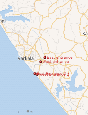
| Location | Varkala, Trivandrum, Kerala |
| Coordinates | Coordinates: 8°44′11″N 76°43′48″E / 8.7365°N 76.730°E |
| Status | Closed |
| Start | 8°44′11″N 76°43′48″E / 8.7365°N 76.730°E |
| End | 8°43′00″N 76°43′16″E / 8.7167°N 76.721°E |
| Operation | |
| Constructed | Travancore |
| Opened | 1867 |
| Owner | Government of Kerala |
| Operator | Kerala Waterways |
| Traffic | Waterways |
| Technical | |
| Length | 1,069.848 m (1.069848 km) |
| No. of lanes | 2 |
| Operating speed | 50 km/h (31 mph) |
| Tunnel clearance | 10 metres (33 ft) |
 |
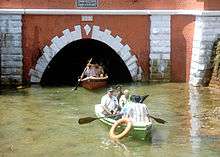
Varkala Tunnel System, situated in municipality of Varkala of Trivandrum,Kerala, India, also known Varkala Canal, is one of the historic sites of the region. This site was constructed by the Travancore Kingdom to establish an inland waterway that was meant to serve as a trade route. The construction of the two long tunnels was started around the mid-1860s and first one opened in 1867 and took around 14 years to complete total of 1km long tunnels.[1]
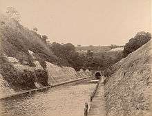
With a length of 1,069.848 metres (1.069848 km), the two tunnel played a vital role in transferring ferry goods and people from capital city Trivandrum to Kollam during the pre-independence era. The tunnel is located under the main cliff of the region and represents the architectural excellence of the workers and engineers of that era.
.jpg)
Built under the supervision of T. Mahadeva Rao, the dewan of Travancore Kingdom, the tunnel also provides way to Varkala’s TS canal, which passes through this delicate structure [2]
References
- ↑ Wright, Colin. "Varkala Tunnel". Bl.uk. Retrieved 14 September 2018.
- ↑