Kundara
| Kundara Kundara | |
|---|---|
| Census Town | |
 Kundara Location in Kerala, India  Kundara Kundara (India) | |
| Coordinates: 8°59′48.84″N 76°52′19.56″E / 8.9969000°N 76.8721000°ECoordinates: 8°59′48.84″N 76°52′19.56″E / 8.9969000°N 76.8721000°E | |
| Country |
|
| State | Kerala |
| District | Kollam |
| Elevation | 37 m (121 ft) |
| Population (2011) | |
| • Total | 33,959[1] |
| Languages | |
| • Official | Malayalam, English |
| Time zone | UTC+5:30 (IST) |
| PIN | 690501 |
| Telephone code | +91 (0)474 |
| ISO 3166 code | IN-KL |
| Vehicle registration | KL-02 |
| Nearest city | Kollam (13 km) |
| Sex ratio | 1096 ♂/♀ |
| Literacy | 93.99% |
| Civic agency | Elamballoor Panchayat |
| Climate | Am/Aw (Köppen) |
| Avg. annual temperature | 27.2 °C (81.0 °F) |
| Avg. summer temperature | 35 °C (95 °F) |
| Avg. winter temperature | 24.4 °C (75.9 °F) |
Kundara is a census town in Kerala and is part of Kollam Metropolitan Area, India.[2] Kundara is situated 13 km east of Kollam city, 14 km west of Kottarakkara and 24 km north of Paravur. Kundara is significant for its historic involvement in the Indian independence movement.[3] Kundara was once the industrial hub of Southern Kerala, which was the home to prominent industrial companies including Kerala Electricals Limited, the Aluminium Industry Limited of Kundara, and the Lakshmi Starch company. Many of these companies have since failed and Kundara is attempting to revive this industrial tradition by developing Technopark Kollam.[4][5]
Kundara is located on the shores of Kanjiracode Lake, a branch of Ashtamudi Lake which has one of the finest quality Green chromide (Karimeen) fish available in India. This lake recently received Marine Stewardship council recognition for sustainable fishing.[6]
History
Kundara has a prominent place in the history of Kerala, having gone through an independence struggle in 1809 due to the Kundara proclamation. The movement was first spearheaded by Velu Thampi Dalawa, and later by the princely state of Diwan of Travancore.[7]
Demographics
As of the 2011 Census of India,[9] Kundara is a census town in Kollam District in the state of Kerala with a total population of 33,959. The population of children aged 0-6 is 3243, representing 9.55% of the total population of Kundara. The female sex ratio is 1096 per 1000 males, against state average of 1084 and the child sex ratio is 993 females per 1000 males, compared to the Kerala state average of 964. Kundara's literacy rate is 93.99%, lower than the state average of 95%. The male literacy is 96.42% and the female literacy rate is 91.80%.
Politics
Kundara is a constituency of the Legislative Assembly of Kerala. M.L.A, J. Mercykutty Amma is the sitting minister in the State Cabinet. Kundara is a part of Kollam, and has a Parliament constituency.
Transport
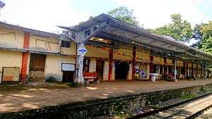
Kundara and Kundara East are the railway stations in Kundara town. In Kerala it is very rare to have more than one railway station in a town.[10][11] The various town stations form the Kollam-Sengottai branch line which connects Kerala with Tamil Nadu. National Highway 744 (India) and National Highway 183 (India) pass through Kundara, and numerous private operators and KSRTC buses use these highways to move between Kundara and Kollam, Kayamkulam, Punalur, Tenkasi, Madurai, and Tirunelveli. The nearest airport is Trivandrum International Airport.
References
- ↑ "Elampalloor Population Census 2011". Census 2011. Census Population 2015 Data. Retrieved 9 November 2016.
- ↑ "Thrikadavur becomes part of Kollam city". The Hindu. Retrieved 10 November 2016.
- ↑ Rajeev, Sharat Sunder (2015-10-16). "The unsung artist". The Hindu. ISSN 0971-751X. Retrieved 2016-11-09.
- ↑ "Kollam Urban Region". Census 2011. Retrieved September 21, 2014.
- ↑ "Kollam city population Census". census2011.co.in. Retrieved 10 November 2016.
- ↑ "Kerala's Ashtamudi lake gets recognition for sustainable clam fishing". The Hindu. 2014-11-07. ISSN 0971-751X. Retrieved 2016-11-09.
- ↑ Rajeev, Sharat Sunder (2016-05-06). "Home of the brave". The Hindu. ISSN 0971-751X. Retrieved 2016-11-09.
- ↑ "Kundara/Elamballoor Town Census 2011 data". Census2011. Retrieved 27 October 2016.
- ↑ "Elampalloor City Population Census 2011 - Kerala". www.census2011.co.in. Retrieved 2016-11-09.
- ↑ "Kundara East Railway Station". India Rail Info. Retrieved 10 November 2016.
- ↑ "Kundara Railway Station". India Rail Info. Retrieved 10 November 2016.
| Wikimedia Commons has media related to Kundara. |
| City Corporations |  | ||||||||||||
|---|---|---|---|---|---|---|---|---|---|---|---|---|---|
| Municipalities | |||||||||||||
| Talukas and villages |
| ||||||||||||