Vandiperiyar
| Vandiperiyar വണ്ടിപ്പെരിയാർ periyar | |
|---|---|
| Town | |
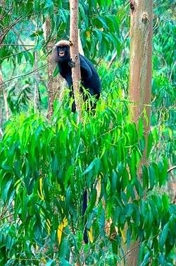 Lion tailed Macaque at Vandiperiyar | |
 Vandiperiyar Location in Kerala, India  Vandiperiyar Vandiperiyar (India) | |
| Coordinates: 9°34′12″N 77°5′26″E / 9.57000°N 77.09056°ECoordinates: 9°34′12″N 77°5′26″E / 9.57000°N 77.09056°E | |
| Country |
|
| State | Kerala |
| District | Idukki |
| Elevation | 836 m (2,743 ft) |
| Population | |
| • Total | 19,519 (2,001) |
| Languages. | |
| • Official | Malayalam, English |
| Time zone | UTC+5:30 (IST) |
| PIN | 685533 |
| Vehicle registration | KL-37 |
| Nearest city | Kumily |
Vandiperiyar (Malayalam:വണ്ടിപ്പെരിയാർ) is a town in Idukki district, Kerala, India. It is famous for tourism, tea and coffee plantations, black pepper and other spice products. A number of tea factories are situated here. The famous river Periyar flows through the city.
Geography
It is located at an altitude of 836 m above MSL.[1]
The Periyar River flows through Vandiperiyar.
Location
Vandiperiyar is on National Highway 183, directly connected with Kottayam. Thekkady is 18 km away.
Economy
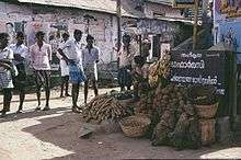
Village vegetable shop
Tea, coffee and pepper plantations are abundant. They are the main source of income for a large number of people.
References
- ↑ http://wikimapia.org/1684867/Vandiperiyar Wikimapia
External links
| Wikimedia Commons has media related to Vandiperiyar. |
This article is issued from
Wikipedia.
The text is licensed under Creative Commons - Attribution - Sharealike.
Additional terms may apply for the media files.