Anthoor
| Anthoor | |
|---|---|
| Town | |
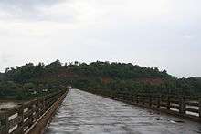
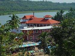 Parassinikkadavu Sree Muthappan Temple | |
| Coordinates: 11°59′13″N 75°22′34″E / 11.987°N 75.376°ECoordinates: 11°59′13″N 75°22′34″E / 11.987°N 75.376°E | |
| Country |
|
| State | Kerala |
| District | Kannur |
| Taluka | Taliparamba |
| Government | |
| • Body | Municipal Council |
| Area | |
| • Total | 28.44 km2 (10.98 sq mi) |
| Population (2011) | |
| • Total | 36,290 |
| • Density | 1,276/km2 (3,300/sq mi) |
| Languages | |
| • Official | Malayalam, English |
| Time zone | UTC+5:30 (IST) |
| PIN | 670331, 670562, 670563, 670564, 670567. |
| Telephone code | 497278**** |
| ISO 3166 code | IN-KL |
| Vehicle registration | KL-13, KL-59 |
| Sex ratio | 1121 ♂/♀ |
| Literacy | 93.45% |
| Lok Sabha constituency | Kasargod |
| Assembly constituency | Taliparamba |
| Civic Agency | Municipality |
| Climate | pleasant (Köppen) |
| Website | |

Anthoor is a town with a municipality in the Kannur district of the North Malabar region in the Indian state of Kerala. Anthoor is located roughly 14 km from the Kannur Corporation, and it is adjacent to the Taliparamba municipality.[1][2]
Geography
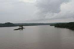
Almost half of Anthoor's border is surrounded by two scenic rivers, the Valapattanam Puzha and the Kuttikkol Puzha. The backwaters at Vellikkeel Eco Tourism Park are a tourist spot.
Anthoor shares borders with Taliparamba and Kurumathur to the north, Kalliasseri and Aroli to the south, Kannapuram to the west, and Mayyil, Kolachery, and Narath to the east.[3][4][5][6][7][8][9]
Etymology
The name Anthoor means "large village." Due to its large size, the town was split into two villages, Anthoor and Morazha. The hill of Anthoor has been mentioned in many Theyyam folk songs and Thottam Pattu (തോറ്റം പാട്ട്).[10]
History
Anthoor was previously under Kolathiri rule. Later, Tipu Sultan adjoined this area as part of the Kingdom of Mysore. During British Raj, the kingdom was under Chirakkal Taluk of Malabar District in the Madras Presidency. After the formation of the Kerala State, this area was made a panchayat in the Cannanore District. Later, the Anthoor Panchayat was merged with the Taliparambu Municipality upon the latter's formation. Presently, Anthoor is an independent municipality of Kannur District of Kerala State.[11][12][13]
Demographics
According to the 2011 India Census, Anthoor had a population of 36,290, with 17,154 men and 19,136 women.[14]
Anthoor was a panchayath consisting of two small villages, Morazha and Anthoor. In 1990, when the government of Kerala announced new municipalities, Anthoor Panchayat was merged with Taliparamba to form the new Municipality of Taliparamba.[15] Later, in 2015, the government separated Anthoor from Taliparamba and made it an independent municipality. Anthoor is a municipality by its population and density, but maintains with the characteristics of a small village.The village is located on NH-17, situated near Taliparamba in the Kannur District of the North Malabar region in Kerala.[1][2]
Administration
- District: Kannur
- Taluk/Tehsil: Taliparamba
- Block: Taliparamba
- Assembly constituency: Taliparamba
- Lok Sabha constituency : Kasargod
- Police Station: Taliparamba
- Nearest Railway Station: Kannapuram
Post offices
- Anchampeedika-670331
- Morazha-670331
- Kanool-670562
- Parassinikkadavu-670563
- Nanicherry-670564
- Keltron Nagar-670567
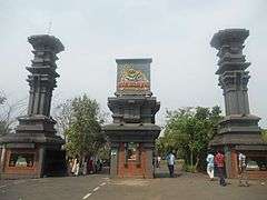
Tourism
Other places of interests
- Neeliyar Kottam (Near Kannur University Main Campus)
- Ozhacrome Temple Pond
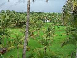
- Paddy Fields of Morazha and Kanool
- Scenic beauty of Punnakulangara
- Hills at Morazha, Muthuvani and Mayilaadu
Theyyam
- Raktha Chamundi at Edappara Chamundeswari Temple, Panthottam
Institutions
- Institute of Co-operative Management, Parassinikkadavu[16]
- Parrasianikkadavu Ayurveda Medical College[9]
- Mangattuparambu Doordarshan Station
- Govt Engineering College, Kannur[4]
- National Institute of Fashion Technology, Kannur[8]
- Kendriya Vidyalaya Keltron Nagar[17]
- KELTRON, Kannur
- Kerala Armed Police 4th Battalion, Kannur
- Kerala Clays and Ceramic Products Limited
- Kannur University Main Campus[5]
Religious institutions
Governance
Anthoor is always 100% CPIM Supporting Area. 14 out 28 of the Municipal[18] Councillors are elected unopposed.[19]
Anthoor Municipality
|
Municipal Wards
- Vellikkeel – 1,
- Morazha −2,
- Kanool – 3,
- Mundapram – 4,
- Mayilaadu – 5,
- Bakkalam – 6,
- Peelery – 7,
- Ayyankovil – 9,
- Kadambery – 9,
- Kolmotta – 10,
- Nanichery – 11,
- Kodallur – 12,
- Mambala – 13,
- Parassini – 14,
- Kovval −15,
- Anthoor – 16,
- Thaliyil – 17,
- Podikkund – 18,
- Thalivayal – 19,
- Dharmashala – 20,
- Punnakulangara – 21,
- Kuttipram – 22,
- C H Nagar – 23,
- Ozhacrom – 24,
- Anchampeedika – 25,
- Veniyil – 26,
- Paliyathuvalappu – 27,
- Panneri – 28.[22]
Transport
The national highway passes through the Dharmashala junction. Mangalore and Mumbai can be accessed on the northern side, and Cochin and Thiruvananthapuram can be accessed on the southern side. The road to the east connects to Mysore and Bangalore. The nearest railway stations are Kannapuram and Kannur on the Mangalore-Palakkad line. There are airports at Mangaluru Airport and Calicut.
References
- 1 2 "New Municipalities of Kerala : Election Results". Trend Kerala – Democracy. Retrieved 2016-03-20.
- 1 2 "Kannur.gov.in : Villages of Kannur District". Kannur.gov.in. Retrieved 2010-07-07.
- ↑ "Kannur District Map : Villages of Kannur". Kannur.gov.in. Retrieved 2010-07-07.
- 1 2 "Govt. College of Engineering Kannur". Gcek.ac.in. Retrieved 2 January 2018.
- 1 2 "Mangattuparamba Campus, Kannur University Campus P. O, Kannur - 670 567". Kannuruniversity.ac.in. Retrieved 2 January 2018.
- ↑ "Kerala Armed Police Battalions". Keralapolicehistory.com. Retrieved 2 January 2018.
- ↑ "Kendriya Vidyalaya Keltron Nagar : Home Page". Kvkeltronnagar.com. Retrieved 2 January 2018.
- 1 2
- 1 2 "Parassinikkadavu Ayurveda Medical College & Hospital, Kannur, Kerala - Panchakarma Guide". Panchakarma.com. Retrieved 2 January 2018.
- ↑ "Anthoor, Kannur District, Kerala, India". Keralatourism.org. Retrieved 2 January 2018.
- ↑ "The Hindu : Kerala News : Electioneering gathering momentum in Taliparamba". Thehindu.com. Retrieved 2 January 2018.
- ↑ "Kannur local bodies poll results leave all parties happy". Indian24news.com. Retrieved 2 January 2018.
- ↑ "Kannur to become corporation; 28 new municipalities on anvil". Times of India. Retrieved 2 January 2018.
- ↑ "Census of India 2011 : KERALA" (PDF). Censusindia.gov.in. Retrieved 2 January 2018.
- ↑ "ആമുഖം - Thaliparamba Municipality". Taliparambamunicipality.in. Retrieved 2 January 2018.
- ↑ "Institute of Cooperative Management Kannur". Icmkannur.org. Retrieved 2 January 2018.
- ↑ "Kendriya Vidyalaya Keltron Nagar :: Home Page". Kvkeltronnagar.com. Retrieved 2 January 2018.
- ↑ "Local Body Elections 2015 - Trend of counting by State Election Commission Kerala". lsgelection.kerala.gov.in. Retrieved 2018-04-13.
- ↑ "Panchayat Elections Kerala". Kerala. Election Commission of India. Retrieved 2016-03-19.
- ↑
- ↑ "JAMES MATHEW MLA of TALIPARAMBA Kerala". Nocorruption.in. Retrieved 2 January 2018.
- ↑