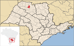
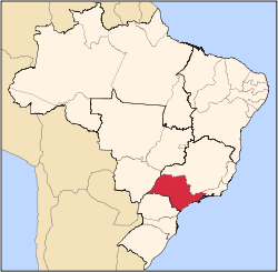
Tanabi is a municipality in the northwestern part of the state of São Paulo, Brazil. The population is 24,055 inhabitants (IBGE/2010).[1]
The city is located 447 km from the city of São Paulo and 30 km from São José do Rio Preto. Tanabi was founded in July 4, 1882.
Demographics
Indicators:
- Population: 24,055 (IBGE/2010)
- Area: 745.8 km² (166.5 sq mi)
- Population density: 32.25/km² (2,451.5/sq mi)
- Urbanization: 90.4% (2010)
- Sex ratio (Males to Females): 101.98 (2011)
- Birth rate: 11.59/1,000 inhabitants (2009)
- Infant mortality: 9.9/1,000 births (2009)
- Homicide rate: 6.8/100 thousand ppl
- HDI: 0.817 (UNDP/2000)
All indicators are from SEADE[2] and IBGE[1]
References
|
|---|
|
|
|
|---|
| Capital | |
|---|
| 1,000,000+ | |
|---|
| 500,000+ | |
|---|
| 200,000+ | |
|---|
| 100,000+ | |
|---|
|
|
|
|---|
São José do Rio Preto |
|---|
| Auriflama | |
|---|
| Catanduva | |
|---|
| Fernandópolis | |
|---|
| Jales | |
|---|
| Nhandeara | |
|---|
| Novo Horizonte | |
|---|
| São José do Rio Preto | |
|---|
| Votuporanga | |
|---|
|
|
|
|
|---|
|
Araçatuba |
|---|
| Andradina | |
|---|
| Araçatuba | |
|---|
| Birigui | |
|---|
|
| |
|
|
Bauru |
|---|
| Avaré | |
|---|
| Bauru | |
|---|
| Botucatu | |
|---|
| Jaú | |
|---|
| Lins | |
|---|
|
|
Campinas |
|---|
| Amparo | |
|---|
| Campinas | |
|---|
| Mogi Mirim | |
|---|
| Pirassununga | |
|---|
| São João da Boa Vista | |
|---|
|
|
Itapetininga |
|---|
| Capão Bonito | |
|---|
| Itapetininga | |
|---|
| Itapeva | |
|---|
| Tatuí | |
|---|
|
|
|
Macro Metropolitana Paulista |
|---|
| Bragança Paulista | |
|---|
| Jundiaí | |
|---|
| Piedade | |
|---|
| Sorocaba | |
|---|
|
|
|
Metropolitana de São Paulo |
|---|
| Franco da Rocha | |
|---|
| Guarulhos | |
|---|
| Itapecerica da Serra | |
|---|
| Mogi das Cruzes | |
|---|
| Osasco | |
|---|
| Santos | |
|---|
| São Paulo | |
|---|
|
|
Piracicaba |
|---|
| Limeira | |
|---|
| Piracicaba | |
|---|
| Rio Claro | |
|---|
|
|
Presidente Prudente |
|---|
| Adamantina | |
|---|
| Dracena | |
|---|
| Presidente Prudente | |
|---|
|
|
Ribeirão Preto |
|---|
| Barretos | |
|---|
| Batatais | |
|---|
| Franca | |
|---|
| Ituverava | |
|---|
| Jaboticabal | |
|---|
| Ribeirão Preto | |
|---|
| São Joaquim da Barra | |
|---|
|
|
São José do Rio Preto |
|---|
| Auriflama | |
|---|
| Catanduva | |
|---|
| Fernandópolis | |
|---|
| Jales | |
|---|
| Nhandeara | |
|---|
| Novo Horizonte | |
|---|
| São José do Rio Preto | |
|---|
| Votuporanga | |
|---|
|
|
Vale do Paraíba Paulista |
|---|
| Bananal | |
|---|
| Campos do Jordão | |
|---|
| Caraguatatuba | |
|---|
| Guaratinguetá | |
|---|
| Paraibuna/Paraitinga | |
|---|
| São José dos Campos | |
|---|
|
|