Suzano
| City of Suzano | ||
|---|---|---|
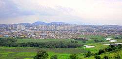 Downtown of Suzano | ||
| ||
| Nickname(s): Cidade das Flores (City of Flowers) | ||
 Location in São Paulo state | ||
 Suzano Location in São Paulo state | ||
| Coordinates: 23°32′34″S 46°18′39″W / 23.54278°S 46.31083°WCoordinates: 23°32′34″S 46°18′39″W / 23.54278°S 46.31083°W | ||
| Country |
| |
| Region | Southeast | |
| State |
| |
| Metropolitan Region | São Paulo | |
| Founded | April 2, 1949 [1] | |
| Government | ||
| • Mayor | Paulo Tokuzumi (PSDB) | |
| Area[2] | ||
| • Total | 206.24 km2 (79.63 sq mi) | |
| Elevation | 749 m (2,457 ft) | |
| Population (2015)[2] | ||
| • Total | 285,280 | |
| • Density | 1,400/km2 (3,600/sq mi) | |
| Time zone | UTC-3 (BRT) | |
| • Summer (DST) | UTC-2 (BRST) | |
| HDI (2000) | 0,775 – medium | |
| Website | Suzano City | |

Suzano is a city in São Paulo, Brazil. It is part of the Metropolitan Region of São Paulo.[3] The population is 285,280 (2015 est.) in an area of 206.24 km².[2] The elevation is 749 m.
Suzano has a large Japanese Brazilian population. It consists of a large downtown area surrounded by residential areas. There are three main roads that travel through the downtown section. One of them is a one-way street (northbound), and two are one-way streets (southbound). It was named after the engineer who built the train station.
Suzano is an important industrial center today, although it was originally agricultural.
Many soldiers who fought in Italy's Monte Castello in World War II were from Suzano.
The city features a medium-sized shopping mall, city hall, train station, frequent bus routes, and a number of tall office and residential buildings.
In comparison with neighboring cities, Suzano has a quite few tall buildings. Most of the city's buildings were built in the 1990s.
Law and government

Suzano's City Hall is located in the Baruel Street in the downtown of the city.
Mayors of Suzano
Transportation
Railroads
Suzano has one train station that is part of CPTM line 11.
Roads
Suzano is crossed by three highways:
References
- ↑ "Histórico de Suzano". Suzano City Hall. Archived from the original on 2012-12-01. Retrieved 2008-07-17.
- 1 2 3 Instituto Brasileiro de Geografia e Estatística
- ↑ Lei Complementar nº 1.139, de 16 de junho de 2011
- ↑ "Paulo Tokuzumi é eleito prefeito de Suzano com 34,47% dos votos". Prefeitura de Suzano.
- ↑ "S - Eleitos 96". TRE-SP.
- ↑ "Resultado Final - SUZANO". TRE-SP.
- ↑ "Resultado por município - Prefeito 1º Turno". TRE-SP.
- ↑ "Prefeitos eleitos no estado de São Paulo" (PDF). TRE-SP. Archived from the original (PDF) on 2012-03-08.
- ↑ "Paulo Tokuzumi é eleito prefeito de Suzano com 34,47% dos votos". TV Diário.
External links
- (in Portuguese) Suzano City Hall Web site
Places adjacent to Suzano | ||||||||||
|---|---|---|---|---|---|---|---|---|---|---|
| ||||||||||