Urupês
| Urupês | ||
|---|---|---|
| Municipality | ||
|
The Municipality of Urupês | ||
| ||
| Nickname(s): Heart's city ("Cidade coração") | ||
| Motto(s): Progressum in operam ("In the work, the progress") | ||
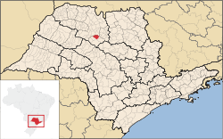 Location of Urupês | ||
 Urupês Location of Urupês | ||
| Coordinates: 21°12′07″S 49°17′24″W / 21.20194°S 49.29000°WCoordinates: 21°12′07″S 49°17′24″W / 21.20194°S 49.29000°W | ||
| Country |
| |
| Region | Southeast | |
| State |
| |
| Founded | September 24, 1928 | |
| Birthday | September 24 | |
| Government | ||
| • Mayor | Alcemir Cássio Gréggio ("Bica") (PTB) | |
| • Vice-Mayor | Maria Luiza Gimpani da Silva | |
| • Chamber President | Armando Aparecido Donizeti Sardella | |
| Area | ||
| • Total | 323.7 km2 (125.0 sq mi) | |
| Elevation | 449 m (1,473 ft) | |
| Population (2010) | ||
| • Total | 12,714 | |
| • Density | 39.27/km2 (101.7/sq mi) | |
| Demonym(s) | urupeense | |
| Time zone | UTC-3 (BRT) | |
| • Summer (DST) | UTC-2 (BRST) | |
| Postal Code | 15850-000 | |
| Area code(s) | +55 17 | |
| Website | Prefecture of Urupês | |

Urupês is a municipality in the state of São Paulo, Brazil. The city has a population of 12,714 inhabitants and an area of 323.7 km².[1]
Urupês is located in the northwest of the state of São Paulo and it belongs to the Mesoregion of Novo Horizonte.
References
- ↑ "IBGE Census" (in Portuguese). IBGE.gov.br. Retrieved 18 June 2018.
This article is issued from
Wikipedia.
The text is licensed under Creative Commons - Attribution - Sharealike.
Additional terms may apply for the media files.