Mogi das Cruzes
| Mogi das Cruzes | |||
|---|---|---|---|
| Municipality | |||
 | |||
| |||
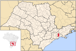 Location in São Paulo state | |||
 Mogi das Cruzes Location in Brazil | |||
| Coordinates: 23°31′22″S 46°11′35″W / 23.52278°S 46.19306°WCoordinates: 23°31′22″S 46°11′35″W / 23.52278°S 46.19306°W | |||
| Country |
| ||
| Region | Southeast Region | ||
| State | São Paulo | ||
| Government | |||
| • Mayor | Marcus Melo (PSD) | ||
| Area | |||
| • Total | 713 km2 (275 sq mi) | ||
| Elevation | 780 m (2,560 ft) | ||
| Population (2015) | |||
| • Total | 424,633 | ||
| • Density | 600/km2 (1,500/sq mi) | ||
| Time zone | BRT/BRST (UTC-3/-2) | ||
| Website |
www | ||

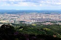
Mogi das Cruzes (Portuguese pronunciation: [moˈʒi] or [muˈʒi ðɐs ˈkɾuzis]) is a municipality in the state of São Paulo, Brazil, located within the metropolitan region of the state capital of the city of São Paulo. The population is 424,633 (2015 est.) in an area of 713 km².[1] It is located 40 km to the east of the city of São Paulo. It was founded in 1560 by the bandeirantes.[2]
Districts
The municipality is subdivided into the following districts:
- Brás Cubas (named after Brás Cubas)
- Biritiba-Ussu
- César de Sousa
- Jundiapeba
- Quatinga
- Sabaúna
- Taiaçupeba
Notable residents
- Bruno Cazarine - professional footballer, played at top levels in Brazil, Europe, Middle East, Asia and currently in Australia with Sydney FC.
- Edmar Halovskyi - professional footballer, plays for Ukrainian national team.
- Maikon Leite - professional footballer, plays for Figueirense.
- Maurício de Sousa - cartoonist, creator of Monica's Gang.
- Neymar - professional footballer, plays for Paris Saint-Germain and Brazilian national team.
- Yan Gomes - baseball catcher, plays for the Cleveland Indians of Major League Baseball.
- Zhang Daqian - Chinese artist and forger.
References
- ↑ Instituto Brasileiro de Geografia e Estatística
- ↑ Grinberg, Isaac (1980). Gaspar Vaz, fundador de Mogi das Cruzes (in Portuguese). s.n. p. 9. Retrieved 28 January 2013.
External links

- Official website of Mogi das Cruzes Municipal Government.
Places adjacent to Mogi das Cruzes | ||||||||||
|---|---|---|---|---|---|---|---|---|---|---|
| ||||||||||
This article is issued from
Wikipedia.
The text is licensed under Creative Commons - Attribution - Sharealike.
Additional terms may apply for the media files.