Cotia
| Cotia | |||
|---|---|---|---|
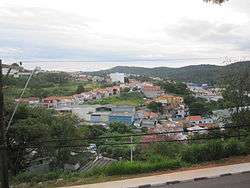 View of Cotia | |||
| |||
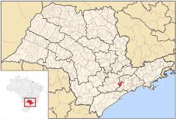 Location in the state of São Paulo and Brazil | |||
 Cotia Location in the state of São Paulo and Brazil | |||
| Coordinates: 23°36′15″S 46°55′10″W / 23.60417°S 46.91944°WCoordinates: 23°36′15″S 46°55′10″W / 23.60417°S 46.91944°W | |||
| Country | Brazil | ||
| Region | Southeast | ||
| State | São Paulo | ||
| Founded | April 2, 1856 | ||
| Government | |||
| • Mayor | Carlão Camago (PSDB) | ||
| Area | |||
| • Total | 323.99 km2 (125.09 sq mi) | ||
| Elevation | 853 m (2,799 ft) | ||
| Population (2015) | |||
| • Total | 229,548 | ||
| • Density | 710/km2 (1,800/sq mi) | ||
| [1] | |||
| Time zone | UTC-3 (UTC-3) | ||
| • Summer (DST) | UTC-2 (UTC-2) | ||
| HDI (2000) | 0.826 – high[2] | ||
| Website | Prefeitura Municipal de Cotia | ||

Cotia is a municipality in the state of São Paulo in Brazil. It is part of the Metropolitan Region of São Paulo.[3] The population is 229,548 (2015 est.) in an area of 323.99 km².[1] The city is at an altitude of 853 m. Cotia is linked with the Rodovia Raposo Tavares highway.
History
Cotia was founded in 1580, and was an active village during the "bandeiras" expeditions. In 1626, Raposo Tavares and his companions arrived in the city. The "Sítio do Mandú" and "Sítio do Padre Inácio" (Mandu's Ranch and Priest Inácio's Ranch) were some of the first rural houses to be built there. Nowadays, they are preserved by the "Instituto Brasileiro de Patrimônio Cultural. Cotia was declared an independent municipality on April 2, 1856. According to the 1980 demographic census, the city had a population of over 62 thousand people.
Geography
The city is located west of São Paulo, and has a terrain made of valleys and mountains, reaching a maximum altitude of 1,074 meters above sea level [4]
The city has the Cotia River as its main river.
The city has a densely populated urban area, but the less developed areas to the west attract people interested in ecotourism. The only naturally occurring case of Brazilian hemorrhagic fever took place here.
Population history
| Year | Population |
|---|---|
| 2003 | 161,782 |
| 2004 | 170,206 |
| 2006 | 179,685 |
| 2015 | 229,548 |
See also
- Granja Viana, a district of Cotia
References
- 1 2 Instituto Brasileiro de Geografia e Estatística
- ↑ "Archived copy". Archived from the original on 2009-10-03. Retrieved 2009-12-17. - UNDP
- ↑ Lei Complementar nº 1.139, de 16 de junho de 2011
- ↑ Terrain of the city at CityBrazil.com.br
External links
![]()
- (in Portuguese) http://www.cotia.sp.gov.br
- (in Portuguese) Cotia on citybrazil.com.br
- (in Portuguese) Encontra Cotia - Find everything about Cotia city
Places adjacent to Cotia | ||||||||||
|---|---|---|---|---|---|---|---|---|---|---|
| ||||||||||