Jaguariúna
| Jaguariúna | |||
|---|---|---|---|
| Municipality | |||
| |||
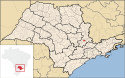 Location in São Paulo state | |||
 Jaguariúna Location in Brazil | |||
| Coordinates: 22°40′48″S 46°59′24″W / 22.68000°S 46.99000°WCoordinates: 22°40′48″S 46°59′24″W / 22.68000°S 46.99000°W | |||
| Country |
| ||
| Region | Southeast Brazil | ||
| State | São Paulo | ||
| Metropolitan Region | Campinas | ||
| Area | |||
| • Total | 141.39 km2 (54.59 sq mi) | ||
| Elevation | 584 m (1,916 ft) | ||
| Population (2015) | |||
| • Total | 51,907 | ||
| • Density | 370/km2 (950/sq mi) | ||
| Time zone | UTC-3 (BRT) | ||
| • Summer (DST) | UTC-2 (BRST) | ||

Jaguariúna is a municipality in the state of São Paulo in Brazil. It is part of the Metropolitan Region of Campinas.[1] The population is 51,907 (2015 est.) in an area of 141.39 km².[2] The elevation is 584 m. This place name comes from the Tupi language and means the river of the black Jaguars.
References
| Wikimedia Commons has media related to Jaguariúna. |
This article is issued from
Wikipedia.
The text is licensed under Creative Commons - Attribution - Sharealike.
Additional terms may apply for the media files.