Transport in São Paulo
Transport in São Paulo plays a key role in the date-to-day life of the people of São Paulo. Although lacking in strong infrastructure, various methods of public transport are offered in the city, including a complex bus system run by SPTrans, and various subway and railway lines. A contactless smartcard is used for fare collection for the buses, subway, and railway systems. São Paulo also has three airports.
Bus System
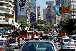
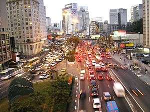
Over 16,000 buses form the bulk of public transport in São Paulo; they include about 290 trolley buses.[1] Except for a small network overseen by the EMTU, all bus lines are operated by concessionaires under the supervision of SPTrans, a municipal company responsible for the planning and management of public transport. Some of the SPTrans buses are painted in white, while others are painted with region-specific colors. Until recently, informal transport vans had a large presence in the city, but the vast majority of such vans are now registered with the city council, legalized, and operating under the same color scheme used in the main system. To increase efficiency in the city, São Paulo is implementing a bus rapid transit system called the Expresso Tiradentes. There is also a system of reserved bus lanes, which are placed on large avenues and connected with the underground or suburban train stations.
Rail transport

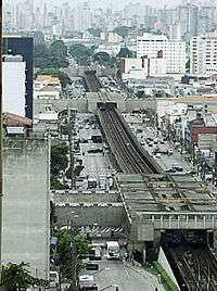
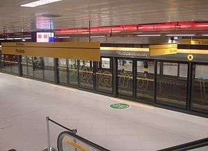
With 13 lines and a total length of 367 km (228 mi) (of which about 230 km or 140 mi is within the Sao Paulo municipal boundaries)[notes 1], the Sao Paulo Metropolitan Transport Network is the largest rail transport system in Latin America.[2]
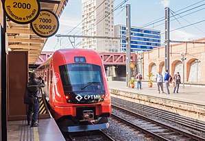
The network transports about 8 million people daily[3] and it is operated by four different companies. Two are state-owned: São Paulo Metro[4] with 6 lines, 83 stations and 93.6 km (58.2 mi) of lines,[5] and the Companhia Paulista de Trens Metropolitanos (CPTM), with 7 lines, 94 stations and 273 km (170 mi) of lines.[6] The other two are private: ViaQuatro, which won the public-private partnership to operate Line 4 - Yellow for 30 years, which can be renewable for another 30 years; and ViaMobilidade, which operates Line 5 - Lilac and the future Line 17 - Gold[7].
Connections between lines operated by different companies is usually free, with the only two exceptions being Tatuapé and Corinthians-Itaquera stations, where connections are paid during rush-hours and free during other periods.
São Paulo used to have tram lines during the first half of the 20th century, but they were eradicated due to the expansion of the bus system.[8]
There are currently 6 operational lines in the São Paulo Metro and 2 under construction:
- Line 1 - Blue: The first Metrô line built. Connects the North and the South Side of São Paulo. Connections are available for the Green, Red and Yellow lines, and also CPTM trains. The line serves Tietê and Jabaquara bus terminals.
- Line 2 - Green: Transverses the Avenida Paulista ridge, connecting Ipiranga to Vila Madalena, and connecting to the Blue and Yellow lines.
- Line 3 - Red: One of São Paulo's busiest lines, it connects the East Side to the West Side. Connections to the Blue and Yellow lines are possible, as are with CPTM trains. The Barra Funda bus terminal is located on this line.
- Line 4 - Yellow: Connects the central Luz station to the South side in a route constructed immediately below the Consolação and Rebouças avenues. Connections are available to the Blue, Green and Red lines and to CPTM trains.
- Line 5 - Lilac: Will connect the southern part of the city with Emerald, Blue and Green lines and in 2019 with Gold line. Only part of the line is currently operational (from Capao Redondo Station to Moema), connecting to CPTM trains at Santo Amaro station. The line is expected to be completed by the end of 2018.
- Line 6 - Orange (under construction): Announced in 2008 and construction initiated in 2015, the Orange Line will connect the borough of Freguesia do Ó, in the northwestern side of the city to downtown São Paulo. It will be connected to the subway lines 1 and 4, as well as the line 7 of CPTM. As of March 2018, construction is paralyzed due to problems with funding.
- Line 15 - Silver: This is the first high-capacity monorail line in the world. It runs east from Vila Prudente station (integrated with line 2 - Green). By April 2018 six stations had opened; an extension to Jardin Colonial station is currently under construction.
- Line 17 - Gold (under construction): Monorail line that will connect Morumbi station with the Congonhas Airport. It will be connected to the lines 5 and 9. Expected to open in 2019.
The following lines are managed by CPTM:
- Line 7 - Ruby: Formerly the northern part of the old São Paulo Railway, it connects the Luz station downtown to the city of Francisco Morato, crossing all of the northwestern side of the city. An operational extension connects Francisco Morato to the city of Jundiaí. This is the longest line of the railway system in São Paulo.
- Line 8 - Diamond: Formerly part of the old Estrada de Ferro Sorocabana, it connects the Júlio Prestes station downtown to Itapevi, going across the western side of the city. An operational extension with another train links this line to four more stations in Itapevi. The last station (Amador Bueno) is placed near the border with São Roque. The Júlio Prestes station houses the State of the Art concert hall Sala Cidade de São Paulo.
- Line 9 - Emerald: It's located along the Nações Unidas Avenue (Marginal Pinheiros), and connects the region of the Interlagos Speedway to the neighbouring city of Osasco. Presently, it makes the only connection with the subway Line 5 - Lilac.
- Line 10 - Turquoise: Formerly the southern part of the old São Paulo Railway, it's actually a continuation of the Line 7 - Ruby, and crosses the ABC Region.
- Line 11 - Coral: Also known as "Expresso Leste" (East Express), it crosses all the eastern side of São Paulo from downtown, to Guaianases. It is within the largest distance between two stations (between Tatuapé and Itaquera) in all the railway net. There is an operational extension from Guaianases to the campus of the Universidade de Mogi das Cruzes, in the city of Mogi das Cruzes.
- Line 12 - Sapphire: It crosses the northeastern side of São Paulo, from the Brás station downtown until the city of Itaquaquecetuba.
- Line 13 - Jade: Connects Goulart Engineer station to São Paulo–Guarulhos International Airport (GRU).
Future complete system
This table includes future extensions and lines for Metro and CPTM:
| Line | Color | Terminals | Length (km) | Stations | System |
|---|---|---|---|---|---|
| 1 | Blue | Tucuruvi ↔ Jabaquara | 20.2 | 23 | Metro |
| 2 | Green | Vila Madalena ↔ Cidade Tiradentes | 38.4 | 31 | Metro |
| 3 | Red | Palmeiras-Barra Funda ↔ Corinthians-Itaquera | 22 | 18 | Metro |
| 4 | Yellow | Luz ↔ Vila Sônia | 12.8 | 11 | Metro |
| 5 | Lilac | Capão Redondo ↔ Chácara Klabin | 19.8 | 17 | Metro |
| 6 | Orange | Brasilândia ↔ São Joaquim | 14.9 | 15 | Metro |
| 7 | Ruby | Luz ↔ Jundiaí | 60.5 | 19 | CPTM |
| 8 | Diamond | Júlio Prestes ↔ Amador Bueno | 41.7 | 24 | CPTM |
| 9 | Emerald | Osasco ↔ Grajaú | 31.8 | 18 | CPTM |
| 10 | Turquoise | Brás ↔ Rio Grande da Serra | 37.2 | 14 | CPTM |
| Express Line 10 | Turquoise | Tamanduateí ↔ Prefeito Celso Daniel-Santo André | 9.2 | 3 | CPTM |
| 11 | Coral | Luz ↔ Estudantes | 50.8 | 17 | CPTM |
| 12 | Sapphire | Brás ↔ Calmon Viana | 38.8 | 16 | CPTM |
| 13 | Jade | Engenheiro Goulart ↔ Aeroporto de Guarulhos | 12.2 | 3 | CPTM |
| 14 | Onyx | Luz ↔ Aeroporto Internacional de Guarulhos/Cumbica | 28.3 | 3 | CPTM |
| 15 | Silver | Vila Prudente ↔ Jardim colonial | 13 | 11 | Metro |
| 17 | Gold | São Paulo - Morumbi ↔ São Judas / Jabaquara | 21.5 | 20 | Metro |
| Suzano-Estudantes Light Rail | Coral | Suzano ↔ Estudantes | 13.8 | 11 | CPTM |
| Grand Total | - | - | 521 | 289 | - |
Public Transportation Statistics
The average amount of time people spend commuting with public transit in São Paulo, for example to and from work, on a weekday is 93 min. 30% of public transit riders, ride for more than 2 hours every day. The average amount of time people wait at a stop or station for public transit is 19 min, while 35% of riders wait for over 20 minutes on average every day. The average distance people usually ride in a single trip with public transit is 8.1 km (5.0 mi), while 18% travel for over 12 km (7.5 mi) in a single direction.[9]
Airfare
Airports
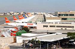
São Paulo has three airports. Two of them, São Paulo/Guarulhos International Airport and Congonhas-São Paulo Airport are located in the metropolitan area, while the third, Campo de Marte, is located north of the city center. Campo de Marte also hosts the Ventura Goodyear Blimp.
Congonhas Airport operates domestic and regional flights, mainly to Rio de Janeiro, Belo Horizonte and Brasília. Guarulhos International Airport, also known to São Paulo dwellers as "Cumbica", is located 25 km (16 mi) North East of the city center, in the neighbouring city of Guarulhos. Guarulhos airport operates both domestic and international flights. Major Brazilian airlines handled by Congonhas Airport and Guarulhos Airport include TAM Airlines, Gol Transportes Aéreos, Azul Brazilian Airlines, and Avianca Brasil. Campo de Marte airport handles some private and small-sized airplanes.
In 2006, about 34.3 million people used the city's airports (mainly from Congonhas and Guarulhos International Airport, the only two operating commercial flights). Infraero, Brazil's main aviation authority, estimates that with the remodelling of Guarulhos Airport, São Paulo's airports will be able to handle about 45 million passengers a year within the next five years.
Heliports
São Paulo has the largest fleet of helicopters in the world, with around 500 registered helicopters and 700 flights per day in the city.[10] The owners are an elite wealthy class who take advantage of approximately one hundred helipads and heliports to conveniently avoid heavy traffic. In addition, there are many air taxi companies in the city, used mostly by the upper class to travel between São Paulo and Rio de Janeiro.
Motorways
Roads
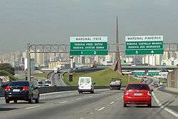
Many Brazilian highways pass through or start in São Paulo itself, including the BR-116, Rodovia dos Bandeirantes, Rodovia Raposo Tavares, the Rodovia Anhangüera, Rodovia dos Imigrantes, Rodovia Castelo Branco, and Via Dutra.
Rodoanel
The Rodoanel Mario Covas (SP-21) (also known as Rodoanel Metropolitano de São Paulo or simply Rodoanel) is a motorway being built around the center of the metropolitan region of São Paulo in an attempt to alleviate traffic intensity of trucks along the city's two riverside highways (Pinheiros and Tietê).
The Rodoanel is being constructed as a multi-lane, limited-access freeway, with large sections to be built in unoccupied regions: along the edge of forests, close to residential areas, etc. This is in an effort to prevent squatting and development in environmentally sensitive areas along the route. Construction is being carried out in four phases: west, south, east and north. As of mid-2010, the west and south section have been completed. The beginning of construction on the east section is planned for February 2011. Due to the rougher terrain and environmental concerns, there is no projected date for the initiation of construction on the northern section.
Travel Restrictions
Similar to the Hoy No Circula program in Mexico, São Paulo has implemented restrictions on travel to maintain the quality of air. Drivers must respect a certain schedule according to the last digit of their car's license plate number.
Interconnected Roads
| West (2002) | South (2010) | East (2014) | North (2018) |
| SP-66 | |||
References
- ↑ 273 km (170 mi) operated by CPTM + 93.6 km (58.2 mi) built by CMSP = total network of 367 km (228 mi), at which 136.5 km (84.8 mi) from CPTM + 93.6 km (58.2 mi) from CMSP = 230.1 km (143.0 mi) are within the limits of the City of Sao Paulo
- ↑ Webb, Mary (Ed.) (2009). Jane's Urban Transport Systems 2009-2010, pp. 42/6. Coulsdon (UK): Jane's Information Group. ISBN 978-0-7106-2903-6.
- ↑ http://www.urbanrail.net/am/spau/sao-paulo.htm
- ↑
- ↑ Downloadable map (pdf) of the underground network retrieved from the Metro SP website.
- ↑ Companhia do Metropolitano inaugura quatro estações da Linha 15-Prata
- ↑ General Data of CPTM - Oficial website
- ↑ https://www.metrocptm.com.br/via-mobilidade-recebera-linha-5-lilas-do-metro-neste-sabado-4/
- ↑
- ↑ "São Paulo Public Transportation Statistics". Global Public Transit Index by Moovit. Retrieved June 19, 2017.

- ↑ http://lab.org.uk/sao-paulo-the-worlds-biggest-helicopter-fleet
Further reading
- "Fighting Resistance, a Mayor Strives to Ease Gridlock in a Brazilian Megacity", New York Times, 4 October 2015
| Commuter rail |  | |
|---|---|---|
| Rapid transit | ||
| Bus lines | ||
| Airports | ||
| Bus terminals | ||
| Intermodal terminals | ||
| |