Boa Esperança do Sul
| Boa Esperança do Sul | |||
|---|---|---|---|
| |||
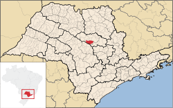 Location of Boa Esperança do Sul within the State of São Paulo | |||
 Boa Esperança do Sul Location of Boa Esperança do Sul within Brazil | |||
| Coordinates: 21°59′33″S 48°23′27″W / 21.99250°S 48.39083°WCoordinates: 21°59′33″S 48°23′27″W / 21.99250°S 48.39083°W | |||
| Country | Brazil | ||
| State | São Paulo | ||
| Mesoregion | Araraquara | ||
| Microregion | Araraquara | ||
| Government | |||
| • Mayor |
Marcão Rosim (2013–2016) (PMDB) | ||
| Area | |||
| • Total | 691.017 km2 (266.803 sq mi) | ||
| Elevation | 490 m (1,610 ft) | ||
| Population (2010[1]) | |||
| • Total | 13,658 | ||
| • Density | 20/km2 (51/sq mi) | ||
| Demonym(s) | Boa-esperancense | ||
| Time zone | UTC-3 (BRT) | ||
| • Summer (DST) | UTC-2 (BRST) | ||
Boa Esperança do Sul is a municipality in the Brazilian state of São Paulo. The population in 2010 was 13,658 and the area is 691.017 square kilometres (266.803 sq mi).[1][2] The elevation is 490 metres (1,610 ft).
History
Boa Esperança do Sul (English: Good Hope of the South) was known as São Sebastião de Boa Esperança (English: St. Sebastian of Good Hope) since the late 1800s. In July 1895, it become a district, with the name of Boa Esperança. In 1944, it was renamed Boa Esperança do Sul.
Government
- Mayor: Marcão Rosim (2013–2016)
Geography
Boa Esperança do Sul is located in the southern-subtropical part of Brazil, at 21 degrees, 59 minutes, 33 second south, and 48 degrees, 23 minutes, 27 seconds west, at an altitude of 490 metres (1,610 ft), in the internal part of the State of São Paulo. It covers an area of 691.017 square kilometres (266.803 sq mi).[2]
- Rivers
- Boa Esperança River
- Jacaré Pepira River
- Jacaré-Guaçu River
Demography
Its population in 2010 was 13,658 inhabitants.[1]
Total population: 13,750 (2011 Census)[3]
- Urban: 10,753
- Rural: 1,820
- Men: 6,391
- Women: 6,182
- Density (hab./km²): 18.81
- Infant mortality up to 1 year old (per thousand): 17.78
- Life expectancy (years): 70.23
- Fertility rate (children per woman): 2.79
- Literacy rate: 85.65%
- Human Development Index (HDI): 0.755
- Income: 0.688
- Longevity: 0.754
- Education: 0,822
Economy
Its economy is based on agriculture, especially coffee, cotton, sugarcane, maize, and soya beans plantations, and also agribusiness, and dairy and beef cattles.
Transport
- SP-255 Highway
References
- 1 2 3 "Censo Populacional 2010" [Population Census 2010]. Censo Populacional 2010 (in Portuguese). IBGE. 29 November 2010. Archived from the original on 2011-05-16.
- 1 2 Área territorial oficial Archived August 23, 2011, at the Wayback Machine.
- ↑ (Source: IPEADATA)
External links