Arapeí
| Arapeí | |
|---|---|
| Municipality | |
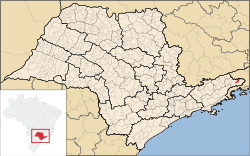 Location in São Paulo state | |
 Arapeí Location in Brazil | |
| Coordinates: 22°40′28″S 44°26′55″W / 22.67444°S 44.44861°WCoordinates: 22°40′28″S 44°26′55″W / 22.67444°S 44.44861°W | |
| Country |
|
| Region | Southeast Brazil |
| State | São Paulo |
| Metropolitan Region | Vale do Paraíba e Litoral Norte |
| Area | |
| • Total | 156.90 km2 (60.58 sq mi) |
| Population (2015) | |
| • Total | 2,524 |
| • Density | 16/km2 (42/sq mi) |
| Time zone | UTC-3 (BRT) |
| • Summer (DST) | UTC-2 (BRST) |
Arapeí is a Brazilian municipality of the eastern part of the state of São Paulo. It is part of the Metropolitan Region of Vale do Paraíba e Litoral Norte.[1] The population is 2,524 (2015 est.) in an area of 156.90 km².[2] Its bordering cities are Resende and Barra Mansa (both in the state of Rio de Janeiro) in the north, Bananal in the southeast and São José do Barreiro in the west.
References
This article is issued from
Wikipedia.
The text is licensed under Creative Commons - Attribution - Sharealike.
Additional terms may apply for the media files.