Arujá
| Arujá | |||
|---|---|---|---|
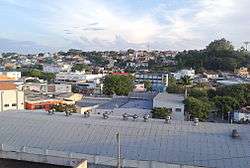 View of downtown Arujá | |||
| |||
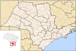 Location of Arujá | |||
 Arujá Location of Arujá | |||
| Coordinates: 23°23′48″S 46°19′16″W / 23.39667°S 46.32111°WCoordinates: 23°23′48″S 46°19′16″W / 23.39667°S 46.32111°W | |||
| Country |
| ||
| Region | Southeast | ||
| State | São Paulo | ||
| Metropolitan Region | São Paulo | ||
| Government | |||
| • Mayor | Abel José Larini (PR) | ||
| Area | |||
| • Total | 96.17 km2 (37.13 sq mi) | ||
| Elevation | 755 m (2,477 ft) | ||
| Population (2015)[1] | |||
| • Total | 83,939 | ||
| • Density | 870/km2 (2,300/sq mi) | ||
| Time zone | UTC-3 (UTC-3) | ||
| • Summer (DST) | UTC-2 (UTC-2) | ||
| HDI (2000) | 0,788 medium | ||
| Website | https://web.archive.org/web/20080430171848/http://www.aruja.sp.gov.br/ | ||

Residential street in Arujá, July 2011
Arujá is a city in the state of São Paulo in Brazil. It is part of the Metropolitan Region of São Paulo.[2] The population is 83,939 (2015 est.) in an area of 96.17 km².[1] Its boundaries are Santa Isabel in the north and the northeast, Mogi das Cruzes in the southeast, Itaquaquecetuba in the south and Guarulhos to the west and the northwest.
The municipality contains part of the 292,000 hectares (720,000 acres) Mananciais do Rio Paraíba do Sul Environmental Protection Area, created in 1982 to protect the sources of the Paraíba do Sul river.[3]
References
- 1 2 Instituto Brasileiro de Geografia e Estatística
- ↑ Lei Complementar nº 1.139, de 16 de junho de 2011
- ↑ Unidade de Conservação: Área de Proteção Ambiental Bacia Hidrográfica do Paraíba do Sul (in Portuguese), MMA: Ministério do Meio Ambiente, retrieved 2016-10-01
External links
| Wikivoyage has a travel guide for Arujá. |
- Guia de Arujá (in Portuguese)
This article is issued from
Wikipedia.
The text is licensed under Creative Commons - Attribution - Sharealike.
Additional terms may apply for the media files.