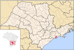
Santos, São Paulo
| Santos | |||
|---|---|---|---|
| Municipality | |||
| Estância Balneária de Santos | |||
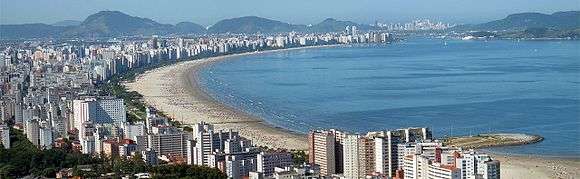
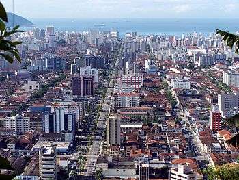
 From top, left to right: Canal 4; skyline from the Bay of Santos; Port of Santos; tourist tram; Museu de Pesca; Beachfront Gardens; panoramic view from Morro do Voturuá. | |||
| |||
|
Motto(s): Patriam Charitatem et Libertatem Docui (Latin: To the homeland I taught charity and liberty) | |||
 | |||
 Santos | |||
| Coordinates: 23°56′13″S 46°19′30″W / 23.93694°S 46.32500°WCoordinates: 23°56′13″S 46°19′30″W / 23.93694°S 46.32500°W | |||
| Country |
| ||
| State |
| ||
| Government | |||
| • Type | Mayor-council | ||
| • Mayor | Paulo Alexandre Barbosa (PSDB) | ||
| Area | |||
| • Total | 280.67 km2 (108.37 sq mi) | ||
| Elevation(AMSL) | 2 m (7 ft) | ||
| Population (2015)[1] | |||
| • Total | 433,966 | ||
| • Density | 1,500/km2 (4,000/sq mi) | ||
| Demonym(s) | Santista | ||
| Time zone | UTC-3 (BRT) | ||
| • Summer (DST) | UTC-2 (BRST) | ||
| Postal code | 11000-000 | ||
| Area code | +55 13 | ||
| Website | www.santos.sp.gov.br | ||
.svg.png)

Santos (Portuguese pronunciation: [ˈsɐ̃tus] (![]()
History
The exportation of coffee from the Port of Santos gave rise to the city and mostly accounted for the wealth of the city at the turn of the 20th century. Exportation and importation through its port have made it the modern city one finds today and turned it into the indispensable outlet for the production of the powerhouse that is São Paulo State. Adorning the landscape of the port city are the canals that are over a hundred years old. In 1899, Santos was the point of entry for the bubonic plague into Brazil.[4] In 1924, it became the seat of the Roman Catholic Diocese of Santos.
In October 2006, light crude oil was discovered off the coast in the Santos basin.[5]
Santos became a tourist city from the 1910s onwards, with the construction of the International Hotel and Parque Balneário and the construction of the beach front gardens in 1935. Until today, tourism in Santos is one of the main economic activities, mainly linked to beaches and historical heritage.
Geography
Santos is about 79 km (49 mi) from the metropolis São Paulo, capital of the state São Paulo.
The municipality contains the Laje de Santos Marine State Park, created in 1993, the first marine park to be created by the state.[6] It is divided into two distinct geographic areas: the heavily urbanized island and the continental area, about 70% of which is protected. The areas differ radically in terms of population, economy and geography.
Insular area
Santos partially lies on the island of São Vicente (Saint Vincent), whose territory is divided with the neighboring municipality of São Vicente. It is a densely urbanized area of 39.4 km2 (15.2 sq mi) that houses almost all the inhabitants of the city. It includes a flat area - Plain Coastal extension of the State of São Paulo - which has altitudes that rarely go above twenty meters above sea level, and an area composed of isolated hills called the Mass of São Vicente, the former home and endowed an urban illegal occupation with a mix of families characterized by high and low incomes, whose height does not exceed 200 meters above sea level.
The flat region of the island is almost completely devoid of native vegetation, although in the north region of the island - especially in the Alemoa, Chico de Paula and Saboó neighbourhoods - there are still remnants of mangroves. Before the occupation of the area of the island by 'chácaras' - rural residences, and subsequently by urbanization, there was a vast flooded land covered by mangroves, the native Atlantic Forest, and coastal vegetation.
On the city hills one can still find vast areas covered by the native Atlantic Forest, in spite of the existing chácaras and banana harvesting farms in the area. The 'Lagoa da Saudade' (Homesickness Lagoon), a pond located in one of the aforementioned hills, Morro Nova Cintra, was known to host a kind of caiman. The lagoon is also a popular destination among families in the city due to its playgrounds, barbecue kiosks, picnic spots and green areas. The disordered occupation of the hills represents both an environmental as well as a geological risk: the deforestation leads to frequent landslides, mainly from January to March, the traditional rainy season in the region.
Most rivers in the island were channeled when engineer Saturnino de Brito designed the system of canals in the city. As examples, we can cite the rivers Dois Rios ("Two Rivers") and Ribeirao dos Soldados ("Soldiers Creek"), which is nowadays referred by santistas as the 'Canal 4' on Avenue Siqueira Campos.
Major water courses cut the island in the north, such as the Rio de São Jorge (St. George River), which suffers from the problems of pollution and silting due to the occupation of its banks by slums.
Climate
Despite the fact that it is located just outside the tropics, Santos has a tropical rainforest climate with no real dry season. Tropical rainforest climates are typically found near the equator, so Santos featuring this type of climate is an exceptional situation. All months of the year averages more than 60 mm of rainfall during the course of the year. Santos features warm weather throughout the year, though June in Santos is somewhat cooler (and drier) than January. The average temperature in the city during the month of June is 23 °C, while the average temperature in January is 28 °C. Precipitation in Santos is appallingly copious, amounting to 2,081 mm (81.9 in) annually. Santos lies in one of the few isolated regions of Brazil outside of the tropical Amazon Basin that receive more than 2,000 mm (79 in) of total average precipitation annually, although nearby Ubatuba, approximately 140 km (87 mi) to the east-northeast, is considerably wetter than Santos, receiving an average of 2,645 mm (104.1 in) of precipitation annually. The Köppen Climate Classification subtype for this climate is "Af" (Tropical Rainforest Climate).[7]
| Climate data for Santos, Brazil (1961–1990) | |||||||||||||
|---|---|---|---|---|---|---|---|---|---|---|---|---|---|
| Month | Jan | Feb | Mar | Apr | May | Jun | Jul | Aug | Sep | Oct | Nov | Dec | Year |
| Record high °C (°F) | 37.7 (99.9) |
39.0 (102.2) |
38.3 (100.9) |
36.8 (98.2) |
34.8 (94.6) |
34.2 (93.6) |
35.8 (96.4) |
37.3 (99.1) |
37.8 (100) |
37.4 (99.3) |
37.6 (99.7) |
37.9 (100.2) |
39.0 (102.2) |
| Average high °C (°F) | 28.6 (83.5) |
28.9 (84) |
28.1 (82.6) |
26.3 (79.3) |
24.8 (76.6) |
23.2 (73.8) |
22.8 (73) |
22.8 (73) |
22.4 (72.3) |
24.2 (75.6) |
25.8 (78.4) |
27.4 (81.3) |
25.4 (77.7) |
| Daily mean °C (°F) | 25.5 (77.9) |
25.7 (78.3) |
25.1 (77.2) |
23.3 (73.9) |
21.2 (70.2) |
19.6 (67.3) |
18.8 (65.8) |
19.4 (66.9) |
20.0 (68) |
21.4 (70.5) |
23.0 (73.4) |
24.4 (75.9) |
22.3 (72.1) |
| Average low °C (°F) | 22.2 (72) |
22.4 (72.3) |
22.0 (71.6) |
20.1 (68.2) |
17.9 (64.2) |
16.3 (61.3) |
15.5 (59.9) |
16.2 (61.2) |
17.2 (63) |
18.5 (65.3) |
19.9 (67.8) |
21.2 (70.2) |
19.1 (66.4) |
| Record low °C (°F) | 14.6 (58.3) |
13.3 (55.9) |
15.9 (60.6) |
10.9 (51.6) |
9.2 (48.6) |
6.5 (43.7) |
6.2 (43.2) |
8.5 (47.3) |
8.8 (47.8) |
10.4 (50.7) |
12.1 (53.8) |
15.7 (60.3) |
6.2 (43.2) |
| Average precipitation mm (inches) | 255.9 (10.075) |
220.3 (8.673) |
221.1 (8.705) |
193.6 (7.622) |
144.3 (5.681) |
106.2 (4.181) |
121.6 (4.787) |
78.4 (3.087) |
130.2 (5.126) |
146.0 (5.748) |
162.0 (6.378) |
210.9 (8.303) |
1,990.6 (78.37) |
| Average precipitation days (≥ 1.0 mm) | 13 | 12 | 12 | 12 | 9 | 8 | 8 | 8 | 11 | 13 | 12 | 14 | 132 |
| Average relative humidity (%) | 79 | 80 | 83 | 83 | 81 | 81 | 77 | 75 | 82 | 81 | 78 | 79 | 79.9 |
| Mean monthly sunshine hours | 155.8 | 149.4 | 153.8 | 144.9 | 158.7 | 141.3 | 153.0 | 136.3 | 88.3 | 107.8 | 132.3 | 134.3 | 1,655.9 |
| Source: INMET[8] | |||||||||||||
Economy
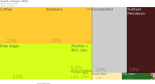
The Port of Santos is the biggest seaport in Latin America, which handled 96 million tons and 2.7 million TEUs in 2010. It has large industrial complexes and shipping centers, which handle a large portion of the world's coffee exports, as well as a number of other Brazilian exports including steel, oil, cars, oranges, bananas and cotton.
As of 2014, the municipality of Santos was the 6th largest exporting city, by value, in Brazil by trading $4.36B (USD) worth of goods.[9] The top four products exported from Santos were raw sugar (23% of total exports), refined petroleum (16%), coffee (15%), and soybeans (13%).[10][11]
Sister cities
See also
References
- 1 2 Instituto Brasileiro de Geografia e Estatística
- ↑ "The City of Santos". www.seemannsmission.org. Adelar Schünke and Lukas Müller. Retrieved 18 September 2014.
- ↑ Assembleia Legislativa do Estado de São Paulo, Lei Complementar Nº 815
- ↑ de Carval ho R; Serra-Freire N; Linardi P; de Almeida A; da Costa J (2001). "Small rodents fleas from the bubonic plague focus located in the Serra dos Órgãos Mountain Range, State of Rio de Janeiro, Brazil". Mem Inst Oswaldo Cruz. 96 (5): 603–9. doi:10.1590/S0074-02762001000500003. PMID 11500756.
- ↑ "BG finds oil in Brazil's Santos basin". Forbes. 10 April 2006.
- ↑ O Parque Estadual Marinho da Laje de Santos (in Portuguese), Instituto Laje Viva, retrieved 2017-01-20
- ↑ Climate Summary for Santos, São Paulo
- ↑ "NORMAIS CLIMATOLÓGICAS DO BRASIL 1961-1990" (in Portuguese). Instituto Nacional de Meteorologia. Retrieved 5 September 2014.
- ↑ DataViva. "Brazilian International Trade by Municipality (2014)", DataViva. Retrieved June 24, 2015.
- ↑ DataViva. "Exports of Santos (2014)", DataViva. Retrieved June 24, 2015.
- ↑ DataViva. "International Trade Data - Santos (2014)", DataViva. Retrieved June 24, 2015.
External links
| Wikimedia Commons has media related to: |
| Wikivoyage has a travel guide for Santos. |
- (in Portuguese) Official website
- SantosCity.com.br - Santos, São Paulo
- A Tribuna
- Santos FC