Campos do Jordão
| Campos do Jordão | |||
|---|---|---|---|
| Municipality | |||
| Município de Campos do Jordão | |||
 Skyline | |||
| |||
| Nickname(s): Brazilian Switzerland | |||
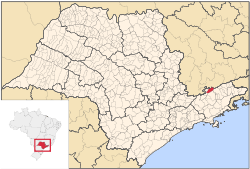 Location of Campos do Jordão in the state of São Paulo | |||
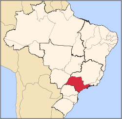
 Campos do Jordão Location of Campos do Jordão in Brazil | |||
| Coordinates: 22°44′20″S 45°35′27″W / 22.73889°S 45.59083°WCoordinates: 22°44′20″S 45°35′27″W / 22.73889°S 45.59083°W | |||
| Country |
| ||
| Region | Southeast | ||
| State |
| ||
| Metropolitan Region | Vale do Paraíba e Litoral Norte | ||
| Founded | April 29, 1874 | ||
| Government | |||
| • Mayor | Frederico Guidoni (PSDB) | ||
| Area | |||
| • Total | 290.520 km2 (112.170 sq mi) | ||
| Elevation | 1,628 m (5,341 ft) | ||
| Population (2017) | |||
| • Total | 51,454 | ||
| • Density | 164.76/km2 (426.7/sq mi) | ||
| Time zone | UTC-3 (Brasilia Official Time) | ||
| • Summer (DST) | UTC-2 (Brazilian Daylight Saving Time) | ||
| Postal Code | 12460-000 | ||
| Area code(s) | +55 12 | ||
| Website | |||
Campos do Jordão (Brazilian Portuguese: [ˈkɐ̃pus du ʒoɾˈdɐ̃w]) is a municipality in the state of São Paulo in southeastern Brazil. It is part of the Metropolitan Region of Vale do Paraíba e Litoral Norte.[1] The population is 51,454 (2017 est.) in an area of 290.52 square kilometres (112.17 sq mi).[2] The city is situated 1,628 metres (5,341 ft) above sea level and is the highest city in Brazil.[3]
Features
The municipality contains the 8,341 hectares (20,610 acres) Campos do Jordão State Park, created in 1941.[4] It contains the 503 hectares (1,240 acres) Mananciais de Campos do Jordão State Park, created in 1993 to protect the water supply of the municipal seat.[5] It also contains the 28,800 hectares (71,000 acres) Campos do Jordão Environmental Protection Area, created in 1984.[6]
The Mantiqueira Mountains provide unique panoramic views, and the municipality's region still has undeveloped old growth Atlantic Forest habitat. The native Brazilian Paraná pine (Araucaria angustifolia) is found here. There are numerous outdoor activities for tourists and winter residents. These include hiking, mountain climbing, treetop cable swings (arborismo), horseback riding, and ATV and motorbike riding. July, of winter season vacations, sees an enormous influx of visitors (more than quadrupling the city's population), due in part to the winter festival of classical music.
Its attractions throughout the year include German, Swiss and Italian cuisine restaurants, bars, and a cable car. There are many pousadas (inns) and chalets. Also, in order to cater to the large number of visitors, several bars, lounges, discos and clubs open during the winter months.
A former state governor had a winter residence in the city, the Boa Vista Palace, which is now a museum in the city.[7]
The city is located in the northeastern side of the State of São Paulo, bordering Minas Gerais in the north. Campos do Jordão is at a distance of 180 km (112 miles) from the City of São Paulo, 334 km (208 miles) from the City of Rio de Janeiro, and 486 km (302 miles) from Belo Horizonte.
Demography
- Total Population: 51,454
- Population Density (inhabitants/km²): 152.86
- Infant Mortality (0 to one year old) (per one thousand): 8.52
- Life Expectancy (years): 75.73
- Total Fertility Rate (Children per Woman): 2.18
- Literacy Rate: 92.28%
- Human Development Index (IHDI): 0.820
- IHDI-M Income: 0.763
- IHDI-M Life Expectancy: 0.846
- IHDI-M Education: 0.851
| Race | Percentage |
|---|---|
| White | 83.9% |
| Multiracial | 12.2% |
| Black | 2.3% |
| Asian | 0.5% |
(Source: IPEADATA)
Economy
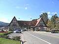
The city's economy is based mainly on tourism; due to its location at high elevation in the Mantiqueira mountains, and traditional European-style architecture. Buildings are mostly vernacular architecture from German, Swiss, or Italian models. Many of the wealthiest residents in the state of São Paulo have winter country houses here.
Despite the high income of many visitors, the HDI (0.820 in 2004) of Campos do Jordão is not very high because the owners of the houses in the best neighbourhoods are not regular inhabitants; these houses are used only during the holidays. The city can be reached from São Paulo mainly by road through the Rodovia Floriano Rodrigues Pinheiro. There is also a picturesque railroad from Pindamonhangaba, used mostly by tourists. At the end of the main road going through Campos do Jordão, there is a state park called Horto Florestal.


Climate
Campos do Jordão features a subtropical highland climate under the Köppen climate classification abbreviated Cfb/Cwb. Despite its location within the tropics, due to the high elevation, temperatures here are cooler than one might expect. The resort town features “spring-like” temperatures throughout the year, with mild summers and cool winters. However, by Brazilian standards, the town is downright cold. In summer, maximum temperatures average 24°C/75°F and minimum temperatures average 13°C/55°F. In winter, maximum temperatures average 18°C/64°F and minimum temperatures average 4°C/39°F. Temperatures drop below zero sometimes in winter (lowest ever recorded: -7.3°C/19°F), but snow is very rare. Similar to many other places with this climate, Campos do Jordão sees a noticeable drying trend during its “low-sun” season. The city sees on average 1800 mm of precipitation, most of which falls from September through March.
The city, due to its elevation, is cold for Brazilian standards. The winter is normally the dry season and the colder weather allows for warm fireplaces and winter foods such as fondue, soups and hot chocolate. In spring and summer, one can see Hydrangea macrophylla blossoming all over the town.
| Climate data for Campos do Jordão, SP (1981–2010, extremes 1961–present) | |||||||||||||
|---|---|---|---|---|---|---|---|---|---|---|---|---|---|
| Month | Jan | Feb | Mar | Apr | May | Jun | Jul | Aug | Sep | Oct | Nov | Dec | Year |
| Record high °C (°F) | 29.0 (84.2) |
28.6 (83.5) |
29.0 (84.2) |
27.0 (80.6) |
24.5 (76.1) |
23.4 (74.1) |
24.4 (75.9) |
28.2 (82.8) |
30.5 (86.9) |
30.0 (86) |
28.6 (83.5) |
28.2 (82.8) |
30.5 (86.9) |
| Average high °C (°F) | 22.5 (72.5) |
23.0 (73.4) |
22.2 (72) |
21.0 (69.8) |
18.5 (65.3) |
17.9 (64.2) |
17.9 (64.2) |
19.7 (67.5) |
20.4 (68.7) |
21.4 (70.5) |
21.6 (70.9) |
22.0 (71.6) |
20.7 (69.3) |
| Daily mean °C (°F) | 17.6 (63.7) |
17.7 (63.9) |
17.0 (62.6) |
15.3 (59.5) |
12.6 (54.7) |
10.4 (50.7) |
10.3 (50.5) |
11.4 (52.5) |
13.5 (56.3) |
15.2 (59.4) |
16.4 (61.5) |
17.0 (62.6) |
14.5 (58.1) |
| Average low °C (°F) | 13.9 (57) |
13.6 (56.5) |
12.8 (55) |
10.6 (51.1) |
7.7 (45.9) |
5.3 (41.5) |
4.6 (40.3) |
5.1 (41.2) |
8.0 (46.4) |
10.3 (50.5) |
11.7 (53.1) |
13.1 (55.6) |
9.7 (49.5) |
| Record low °C (°F) | 5.0 (41) |
4.2 (39.6) |
2.6 (36.7) |
−2.6 (27.3) |
−6.2 (20.8) |
−7.2 (19) |
−6.0 (21.2) |
−5.5 (22.1) |
−2.5 (27.5) |
0.7 (33.3) |
0.3 (32.5) |
1.8 (35.2) |
−7.2 (19) |
| Average precipitation mm (inches) | 253.1 (9.965) |
206.0 (8.11) |
196.7 (7.744) |
85.5 (3.366) |
82.5 (3.248) |
38.0 (1.496) |
45.9 (1.807) |
38.3 (1.508) |
85.8 (3.378) |
133.0 (5.236) |
160.6 (6.323) |
240.0 (9.449) |
1,565.4 (61.63) |
| Average precipitation days (≥ 1.0 mm) | 21 | 16 | 17 | 9 | 7 | 4 | 4 | 4 | 8 | 12 | 14 | 19 | 135 |
| Average relative humidity (%) | 86.1 | 87.1 | 87.5 | 87.2 | 86.9 | 85.3 | 84.5 | 80.9 | 81.5 | 84.2 | 83.8 | 86.8 | 85.2 |
| Mean monthly sunshine hours | 106.4 | 93.6 | 99.8 | 122.9 | 137.2 | 157.9 | 180.3 | 177.9 | 123.8 | 137.2 | 128.0 | 97.6 | 1,562.6 |
| Source #1: Instituto Nacional de Meteorologia[8] | |||||||||||||
| Source #2: Meteo Climat (record highs and lows)[9] | |||||||||||||
Gallery
 City entrance
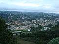 Panoramic view of the district of Capivari
 Home Green Home Hotel
.jpg) View from Morro do Elefante
View from Morro do Elefante_(2).jpg) Photo taken with a tilt-shift lens
Photo taken with a tilt-shift lens.jpg) Vila Capivari district
Vila Capivari district Square
 Square
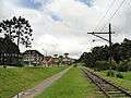 Tram rail
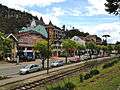 Tram rail
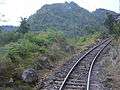 Campos do Jordão railroad
 Cristallo di Pietro Hotel
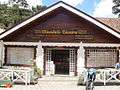 Artisan chocolate shop
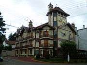 Villa D'Biagy Inn
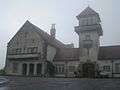 Palácio Boa Vista, the winter residence of the Governor of São Paulo
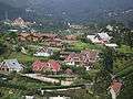 View from Alto do Capivari
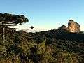 Pedra do Baú State Park, near Campos do Jordão
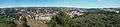 Panorama
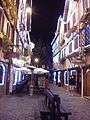 Pedestrian street
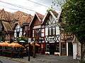 Shops and restaurants
.jpg) Outdoor restaurants at night
Outdoor restaurants at night The city during the winter season
.jpg) The Aspen Mall in Vila Capivari district
The Aspen Mall in Vila Capivari district
References
- ↑ Assembleia Legislativa do Estado de São Paulo, Lei Complementar Nº 1.166
- ↑ Instituto Brasileiro de Geografia e Estatística
- ↑ "IBGE disponibiliza coordenadas e altitudes para 21.304 localidades brasileiras" [IBGE provides coordinates and altitudes to 21,304 Brazilian locations] (in Portuguese). Brazilian Institute of Geography and Statistics (IBGE). Retrieved September 10, 2012.
- ↑ Sobre o Parque (in Portuguese), SAP: Sistema Ambiental Paulista, retrieved 2016-09-27
- ↑ Parque Estadual Mananciais de Campos do Jordão (in Portuguese), SAP: Sistema Ambiental Paulista, retrieved 2016-10-01
- ↑ Área de Proteção Ambiental Campos do Jordão (in Portuguese), Fundação Florestal SP, retrieved 2016-09-29
- ↑ "Palácio Boa Vista" [Boa Vista Palace]. The Artistic-Cultural Collection of the Governmental Palaces of the State of São Paulo. Retrieved September 10, 2012.
- ↑ "Normais Climatológicas Do Brasil 1981–2010" (in Portuguese). Instituto Nacional de Meteorologia. Retrieved 14 October 2018.
- ↑ "Station Campos do Jordão" (in French). Meteo Climat. Retrieved 14 October 2018.
External links
| Wikimedia Commons has media related to Campos do Jordão. |
| Wikivoyage has a travel guide for Campos do Jordão. |
- (in Portuguese) Official Campos do Jordão website
- (in Portuguese) Official Campos do Jordão and Region Convention & Visitors Bureau
- (in Portuguese) Buscacamposdojordao.com: Search engine exclusively for Campos do Jordão
- (in Portuguese) NetCampos - Commercial site with quality useful information
- (in Portuguese) Blog Campos do Jordão
- (in Portuguese) Mapadecamposdojordao.com: Google map of Campos do Jordão — with some locales indicated.
- (in Portuguese) EncontraCamposdoJordão - Find everything about Campos do Jordão
Capital: São Paulo | |||||||||||||||||||||
|  | ||||||||||||||||||||
|
| |||||||||||||||||||||
| |||||||||||||||||||||
| |||||||||||||||||||||
| |||||||||||||||||||||
| |||||||||||||||||||||
| |||||||||||||||||||||
| |||||||||||||||||||||
| |||||||||||||||||||||
| |||||||||||||||||||||
| |||||||||||||||||||||
| |||||||||||||||||||||
| |||||||||||||||||||||