Cleveland, South Carolina
| Cleveland, South Carolina | |
|---|---|
| Unincorporated community | |
 Cleveland  Cleveland | |
| Coordinates: 35°04′20″N 82°31′38″W / 35.07222°N 82.52722°WCoordinates: 35°04′20″N 82°31′38″W / 35.07222°N 82.52722°W | |
| Country | United States |
| State | South Carolina |
| County | Greenville |
| Elevation | 1,001 ft (305 m) |
| Time zone | UTC-5 (Eastern (EST)) |
| • Summer (DST) | UTC-4 (EDT) |
| ZIP code | 29635 |
| Area code(s) | 864 |
| GNIS feature ID | 1221633[1] |
Cleveland is an unincorporated community in Greenville County, South Carolina, United States. Cleveland is located on U.S. Route 276 and South Carolina Highway 11, 8.7 miles (14.0 km) north-northwest of Travelers Rest. Cleveland has a post office with ZIP code 29635, which opened on April 9, 1900.[2][3]
References
- ↑ "Cleveland". Geographic Names Information System. United States Geological Survey.
- ↑ United States Postal Service (2012). "USPS - Look Up a ZIP Code". Retrieved 2012-02-15.
- ↑ "Postmaster Finder - Post Offices by ZIP Code". United States Postal Service. Retrieved August 6, 2013.
Municipalities and communities of Greenville County, South Carolina, United States | ||
|---|---|---|
| Cities | 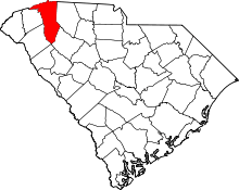 | |
| CDPs | ||
| Unincorporated communities | ||
| Footnotes | ‡This populated place also has portions in an adjacent county or counties | |
This article is issued from
Wikipedia.
The text is licensed under Creative Commons - Attribution - Sharealike.
Additional terms may apply for the media files.