Sainte-Radegonde, Deux-Sèvres
| Sainte-Radegonde | |
|---|---|
| Commune | |
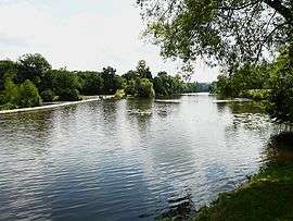 The Thouet river in Sainte-Radegonde | |
 Sainte-Radegonde Location within Nouvelle-Aquitaine region  Sainte-Radegonde | |
| Coordinates: 46°59′07″N 0°14′45″W / 46.9853°N 0.2458°WCoordinates: 46°59′07″N 0°14′45″W / 46.9853°N 0.2458°W | |
| Country | France |
| Region | Nouvelle-Aquitaine |
| Department | Deux-Sèvres |
| Arrondissement | Bressuire |
| Canton | Thouars |
| Intercommunality | Thouarsais |
| Government | |
| • Mayor (2008–2014) | André Froger |
| Area1 | 7.52 km2 (2.90 sq mi) |
| Population (2006)2 | 2,043 |
| • Density | 270/km2 (700/sq mi) |
| Time zone | UTC+1 (CET) |
| • Summer (DST) | UTC+2 (CEST) |
| INSEE/Postal code | 79292 /79100 |
| Elevation |
43–111 m (141–364 ft) (avg. 60 m or 200 ft) |
|
1 French Land Register data, which excludes lakes, ponds, glaciers > 1 km2 (0.386 sq mi or 247 acres) and river estuaries. 2 Population without double counting: residents of multiple communes (e.g., students and military personnel) only counted once. | |
Sainte-Radegonde (sometimes spelled Sainte-Radégonde) is a commune in the Deux-Sèvres department in western France.
See also
References
| Wikimedia Commons has media related to Sainte-Radegonde (Deux-Sèvres). |
This article is issued from
Wikipedia.
The text is licensed under Creative Commons - Attribution - Sharealike.
Additional terms may apply for the media files.