Le Vanneau-Irleau
| Le Vanneau-Irleau | |
|---|---|
| Commune | |
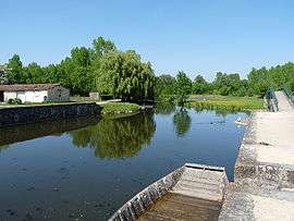 The harbour of Le Vanneau | |
 Le Vanneau-Irleau Location within Nouvelle-Aquitaine region  Le Vanneau-Irleau | |
| Coordinates: 46°17′46″N 0°38′01″W / 46.2961°N 0.6336°WCoordinates: 46°17′46″N 0°38′01″W / 46.2961°N 0.6336°W | |
| Country | France |
| Region | Nouvelle-Aquitaine |
| Department | Deux-Sèvres |
| Arrondissement | Niort |
| Canton | Frontenay-Rohan-Rohan |
| Government | |
| • Mayor (2008–2014) | Robert Gousseau |
| Area1 | 14.17 km2 (5.47 sq mi) |
| Population (2006)2 | 928 |
| • Density | 65/km2 (170/sq mi) |
| Time zone | UTC+1 (CET) |
| • Summer (DST) | UTC+2 (CEST) |
| INSEE/Postal code | 79337 /79270 |
| Elevation |
0–29 m (0–95 ft) (avg. 30 m or 98 ft) |
|
1 French Land Register data, which excludes lakes, ponds, glaciers > 1 km2 (0.386 sq mi or 247 acres) and river estuaries. 2 Population without double counting: residents of multiple communes (e.g., students and military personnel) only counted once. | |
Le Vanneau-Irleau is a commune in the Deux-Sèvres department in western France.
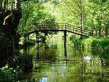
A footbridge over a canal in the Marais Poitevin in Le Vanneau.
See also
References
| Wikimedia Commons has media related to Le Vanneau-Irleau. |
This article is issued from
Wikipedia.
The text is licensed under Creative Commons - Attribution - Sharealike.
Additional terms may apply for the media files.