Glénay
| Glénay | ||
|---|---|---|
| Commune | ||
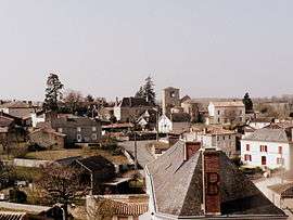 A general view of Glénay | ||
| ||
 Glénay Location within Nouvelle-Aquitaine region  Glénay | ||
| Coordinates: 46°51′40″N 0°14′58″W / 46.8611°N 0.2494°WCoordinates: 46°51′40″N 0°14′58″W / 46.8611°N 0.2494°W | ||
| Country | France | |
| Region | Nouvelle-Aquitaine | |
| Department | Deux-Sèvres | |
| Arrondissement | Bressuire | |
| Canton | Le Val de Thouet | |
| Government | ||
| • Mayor (2014–2020) | David Baptiste | |
| Area1 | 21.14 km2 (8.16 sq mi) | |
| Population (2006)2 | 237 | |
| • Density | 11/km2 (29/sq mi) | |
| Time zone | UTC+1 (CET) | |
| • Summer (DST) | UTC+2 (CEST) | |
| INSEE/Postal code | 79134 /79330 | |
| Elevation |
87–170 m (285–558 ft) (avg. 100 m or 330 ft) | |
|
1 French Land Register data, which excludes lakes, ponds, glaciers > 1 km2 (0.386 sq mi or 247 acres) and river estuaries. 2 Population without double counting: residents of multiple communes (e.g., students and military personnel) only counted once. | ||

Glénay is a commune in the Deux-Sèvres department in the Nouvelle-Aquitaine region in western France. Its inhabitants are called Glénéens. The town is part of the Communité de Communes du Thouarsais. Located in the northern department between the Bressuirais Bocage and the Poitou Gâtine, it is watered by the Thouaret in a hilly landscape. It has a historic heritage, such as the castle and the church, both ranked.
See also
References
| Wikimedia Commons has media related to Glénay. |
This article is issued from
Wikipedia.
The text is licensed under Creative Commons - Attribution - Sharealike.
Additional terms may apply for the media files.