Nueil-les-Aubiers
| Nueil-les-Aubiers | |
|---|---|
| Commune | |
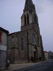 The church of Saint-hilaire | |
 Nueil-les-Aubiers Location within Nouvelle-Aquitaine region  Nueil-les-Aubiers | |
| Coordinates: 46°56′17″N 0°35′19″W / 46.9381°N 0.5886°WCoordinates: 46°56′17″N 0°35′19″W / 46.9381°N 0.5886°W | |
| Country | France |
| Region | Nouvelle-Aquitaine |
| Department | Deux-Sèvres |
| Arrondissement | Bressuire |
| Canton | Mauléon |
| Intercommunality | Delta-Sèvre-Argent |
| Government | |
| • Mayor (2014–2020) | Philippe Brémond |
| Area1 | 98.83 km2 (38.16 sq mi) |
| Population (2006)2 | 5,416 |
| • Density | 55/km2 (140/sq mi) |
| Time zone | UTC+1 (CET) |
| • Summer (DST) | UTC+2 (CEST) |
| INSEE/Postal code | 79195 /79250 |
| Elevation |
94–211 m (308–692 ft) (avg. 126 m or 413 ft) |
|
1 French Land Register data, which excludes lakes, ponds, glaciers > 1 km2 (0.386 sq mi or 247 acres) and river estuaries. 2 Population without double counting: residents of multiple communes (e.g., students and military personnel) only counted once. | |
Nueil-les-Aubiers is a commune in the Deux-Sèvres department in western France.
Twin towns
In 1996 it was twinned with the town of Attleborough in Norfolk, England.
See also
References
| Wikimedia Commons has media related to Nueil-les-Aubiers. |
This article is issued from
Wikipedia.
The text is licensed under Creative Commons - Attribution - Sharealike.
Additional terms may apply for the media files.