Saint-Léger-de-la-Martinière
| Saint-Léger-de-la-Martinière | ||
|---|---|---|
| Commune | ||
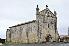 The church in Saint-Léger-de-la-Martinière | ||
| ||
 Saint-Léger-de-la-Martinière Location within Nouvelle-Aquitaine region  Saint-Léger-de-la-Martinière | ||
| Coordinates: 46°13′42″N 0°07′26″W / 46.2283°N 0.1239°WCoordinates: 46°13′42″N 0°07′26″W / 46.2283°N 0.1239°W | ||
| Country | France | |
| Region | Nouvelle-Aquitaine | |
| Department | Deux-Sèvres | |
| Arrondissement | Niort | |
| Canton | Melle | |
| Intercommunality | Canton of Melle | |
| Government | ||
| • Mayor (2008–2014) | Christophe Labrousse | |
| Area1 | 25.64 km2 (9.90 sq mi) | |
| Population (2006)2 | 1,054 | |
| • Density | 41/km2 (110/sq mi) | |
| Time zone | UTC+1 (CET) | |
| • Summer (DST) | UTC+2 (CEST) | |
| INSEE/Postal code | 79264 /79500 | |
| Elevation |
107–183 m (351–600 ft) (avg. 160 m or 520 ft) | |
|
1 French Land Register data, which excludes lakes, ponds, glaciers > 1 km2 (0.386 sq mi or 247 acres) and river estuaries. 2 Population without double counting: residents of multiple communes (e.g., students and military personnel) only counted once. | ||

Saint-Léger-de-la-Martinière is a commune in the Deux-Sèvres department in western France.
See also
References
| Wikimedia Commons has media related to Saint-Léger-de-la-Martinière. |
This article is issued from
Wikipedia.
The text is licensed under Creative Commons - Attribution - Sharealike.
Additional terms may apply for the media files.