Ménigoute
| Ménigoute | ||
|---|---|---|
| Commune | ||
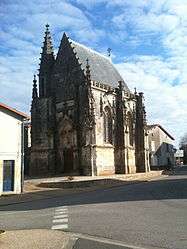 The chapel in Ménigoute | ||
| ||
 Ménigoute Location within Nouvelle-Aquitaine region  Ménigoute | ||
| Coordinates: 46°29′46″N 0°03′28″W / 46.4961°N 0.0578°WCoordinates: 46°29′46″N 0°03′28″W / 46.4961°N 0.0578°W | ||
| Country | France | |
| Region | Nouvelle-Aquitaine | |
| Department | Deux-Sèvres | |
| Arrondissement | Parthenay | |
| Canton | La Gâtine | |
| Intercommunality | CC Parthenay-Gâtine | |
| Government | ||
| • Mayor (2008–2014) | Didier Gaillard | |
| Area1 | 19.22 km2 (7.42 sq mi) | |
| Population (2006)2 | 892 | |
| • Density | 46/km2 (120/sq mi) | |
| Time zone | UTC+1 (CET) | |
| • Summer (DST) | UTC+2 (CEST) | |
| INSEE/Postal code | 79176 /79340 | |
| Elevation |
122–181 m (400–594 ft) (avg. 163 m or 535 ft) | |
|
1 French Land Register data, which excludes lakes, ponds, glaciers > 1 km2 (0.386 sq mi or 247 acres) and river estuaries. 2 Population without double counting: residents of multiple communes (e.g., students and military personnel) only counted once. | ||

Ménigoute is a commune in the Deux-Sèvres department in western France.It has a population of 892.
See also
References
| Wikimedia Commons has media related to Ménigoute. |
This article is issued from
Wikipedia.
The text is licensed under Creative Commons - Attribution - Sharealike.
Additional terms may apply for the media files.