Fenioux, Deux-Sèvres
| Fenioux | |
|---|---|
| Commune | |
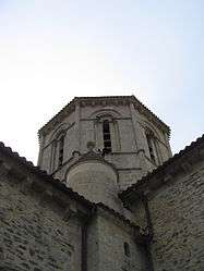 The tower of the church | |
 Fenioux Location within Nouvelle-Aquitaine region  Fenioux | |
| Coordinates: 46°32′44″N 0°29′33″W / 46.5456°N 0.4925°WCoordinates: 46°32′44″N 0°29′33″W / 46.5456°N 0.4925°W | |
| Country | France |
| Region | Nouvelle-Aquitaine |
| Department | Deux-Sèvres |
| Arrondissement | Niort |
| Canton | Autize-Égray |
| Intercommunality | L'Orée de Gâtine |
| Government | |
| • Mayor (2008–2014) | Bernard Hipeau |
| Area1 | 33.65 km2 (12.99 sq mi) |
| Population (2006)2 | 741 |
| • Density | 22/km2 (57/sq mi) |
| Time zone | UTC+1 (CET) |
| • Summer (DST) | UTC+2 (CEST) |
| INSEE/Postal code | 79119 /79160 |
| Elevation |
53–228 m (174–748 ft) (avg. 200 m or 660 ft) |
|
1 French Land Register data, which excludes lakes, ponds, glaciers > 1 km2 (0.386 sq mi or 247 acres) and river estuaries. 2 Population without double counting: residents of multiple communes (e.g., students and military personnel) only counted once. | |
Fenioux is a commune in the Deux-Sèvres department in the Nouvelle-Aquitaine region in western France.
See also
Boasting a fantastic gothic church and a complete Roman tower called a'Lanterne Des Morts' a 'Dead Mans Lantern' used by the Romans to mark their grave sites. There is a small cafe opposite the church but it is rarely open. Don't worry about the hill, there is a car park at the top just past the church on the left, try to avoid parking in the spaces outside the Mayors residence.
References
External links
| Wikimedia Commons has media related to Fenioux (Deux-Sèvres). |
This article is issued from
Wikipedia.
The text is licensed under Creative Commons - Attribution - Sharealike.
Additional terms may apply for the media files.