Missé
| Missé | |
|---|---|
| Commune | |
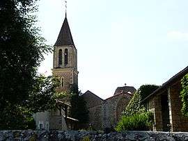 The church in Missé | |
 Missé Location within Nouvelle-Aquitaine region  Missé | |
| Coordinates: 46°56′58″N 0°11′27″W / 46.9494°N 0.1908°WCoordinates: 46°56′58″N 0°11′27″W / 46.9494°N 0.1908°W | |
| Country | France |
| Region | Nouvelle-Aquitaine |
| Department | Deux-Sèvres |
| Arrondissement | Bressuire |
| Canton | Thouars |
| Intercommunality | Thouarsais |
| Government | |
| • Mayor (2008–2014) | Christine Gorry-Bardot |
| Area1 | 12.34 km2 (4.76 sq mi) |
| Population (2006)2 | 877 |
| • Density | 71/km2 (180/sq mi) |
| Time zone | UTC+1 (CET) |
| • Summer (DST) | UTC+2 (CEST) |
| INSEE/Postal code | 79178 /79100 |
| Elevation |
47–117 m (154–384 ft) (avg. 106 m or 348 ft) |
|
1 French Land Register data, which excludes lakes, ponds, glaciers > 1 km2 (0.386 sq mi or 247 acres) and river estuaries. 2 Population without double counting: residents of multiple communes (e.g., students and military personnel) only counted once. | |
Missé is a commune in the Deux-Sèvres department in western France.
It is situated on the River Thouet some 5 km upstream from the town of Thouars, and is the site of a spectacular loop in the river.[1]
See also
References
- ↑ "France for Walkers - The Thouet Valley". France Magazine. Retrieved 2008-06-04.
| Wikimedia Commons has media related to Missé. |
This article is issued from
Wikipedia.
The text is licensed under Creative Commons - Attribution - Sharealike.
Additional terms may apply for the media files.