Geay, Deux-Sèvres
| Geay | |
|---|---|
| Commune | |
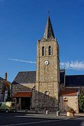 The church of Saint-Maixent | |
 Geay Location within Nouvelle-Aquitaine region  Geay | |
| Coordinates: 46°52′52″N 0°19′30″W / 46.8811°N 0.325°WCoordinates: 46°52′52″N 0°19′30″W / 46.8811°N 0.325°W | |
| Country | France |
| Region | Nouvelle-Aquitaine |
| Department | Deux-Sèvres |
| Arrondissement | Bressuire |
| Canton | Bressuire |
| Government | |
| • Mayor (2008–2014) | Jean-Paul Motard |
| Area1 | 19.25 km2 (7.43 sq mi) |
| Population (2006)2 | 352 |
| • Density | 18/km2 (47/sq mi) |
| Time zone | UTC+1 (CET) |
| • Summer (DST) | UTC+2 (CEST) |
| INSEE/Postal code | 79131 /79330 |
| Elevation |
125–187 m (410–614 ft) (avg. 160 m or 520 ft) |
|
1 French Land Register data, which excludes lakes, ponds, glaciers > 1 km2 (0.386 sq mi or 247 acres) and river estuaries. 2 Population without double counting: residents of multiple communes (e.g., students and military personnel) only counted once. | |
Geay is a commune in the Deux-Sèvres department in the Nouvelle-Aquitaine region in western France.
See also
References
| Wikimedia Commons has media related to Geay (Deux-Sèvres). |
This article is issued from
Wikipedia.
The text is licensed under Creative Commons - Attribution - Sharealike.
Additional terms may apply for the media files.