Saint-Mars-sur-la-Futaie
| Saint-Mars-sur-la-Futaie | |
|---|---|
| Commune | |
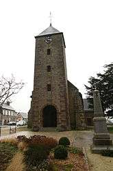 The bell tower of the church | |
 Saint-Mars-sur-la-Futaie Location within Pays de la Loire region  Saint-Mars-sur-la-Futaie | |
| Coordinates: 48°25′58″N 1°00′51″W / 48.4328°N 1.0142°WCoordinates: 48°25′58″N 1°00′51″W / 48.4328°N 1.0142°W | |
| Country | France |
| Region | Pays de la Loire |
| Department | Mayenne |
| Arrondissement | Mayenne |
| Canton | Gorron |
| Intercommunality | Bocage Mayennais |
| Government | |
| • Mayor (2008–2014) | Maurice Roulette |
| Area1 | 21.45 km2 (8.28 sq mi) |
| Population (1999)2 | 623 |
| • Density | 29/km2 (75/sq mi) |
| Time zone | UTC+1 (CET) |
| • Summer (DST) | UTC+2 (CEST) |
| INSEE/Postal code | 53238 /53220 |
| Elevation |
135–252 m (443–827 ft) (avg. 180 m or 590 ft) |
|
1 French Land Register data, which excludes lakes, ponds, glaciers > 1 km2 (0.386 sq mi or 247 acres) and river estuaries. 2 Population without double counting: residents of multiple communes (e.g., students and military personnel) only counted once. | |
Saint Mars sur la Futaie is a commune in the Mayenne department in north-western France. It is notable as the site of the oldest known tree in France, a Hawthorn growing alongside the church, and reputedly planted in the 3rd century.
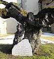 Bole of ancient hawthorn
 Saint Mars sur la Futaie
See also
References
| Wikimedia Commons has media related to Saint-Mars-sur-la-Futaie. |
This article is issued from
Wikipedia.
The text is licensed under Creative Commons - Attribution - Sharealike.
Additional terms may apply for the media files.