Mauléon, Deux-Sèvres
| Mauléon | ||
|---|---|---|
| Commune | ||
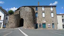 The old fortified gate, in Mauléon | ||
| ||
 Mauléon Location within Nouvelle-Aquitaine region  Mauléon | ||
| Coordinates: 46°55′25″N 0°44′54″W / 46.9236°N 0.7483°WCoordinates: 46°55′25″N 0°44′54″W / 46.9236°N 0.7483°W | ||
| Country | France | |
| Region | Nouvelle-Aquitaine | |
| Department | Deux-Sèvres | |
| Arrondissement | Bressuire | |
| Canton | Mauléon | |
| Intercommunality | Delta-Sèvre-Argent | |
| Government | ||
| • Mayor (2008–2014) | Daniel Amiot | |
| Area1 | 120.64 km2 (46.58 sq mi) | |
| Population (2006)2 | 8,110 | |
| • Density | 67/km2 (170/sq mi) | |
| Time zone | UTC+1 (CET) | |
| • Summer (DST) | UTC+2 (CEST) | |
| INSEE/Postal code | 79079 /79700 | |
| Elevation |
104–226 m (341–741 ft) (avg. 187 m or 614 ft) | |
|
1 French Land Register data, which excludes lakes, ponds, glaciers > 1 km2 (0.386 sq mi or 247 acres) and river estuaries. 2 Population without double counting: residents of multiple communes (e.g., students and military personnel) only counted once. | ||
.svg.png)
Mauléon is a commune in the Deux-Sèvres department in western France. It is around 20 km south-east of Cholet, and around 70 km south-east of Nantes.
History
Mauléon was formed in 1965 by the merger of the two former communes of Châtillon and Saint-Jouin-sous-Châtillon. The territory of the commune also includes the villages of La Chapelle-Largeau, Loublande, Moulins, Rorthais, Saint-Amand-sur-Sèvre, Saint-Aubin-de-Baubigné and Le Temple
See also
References
| Wikimedia Commons has media related to Mauléon (Deux-Sèvres). |
This article is issued from
Wikipedia.
The text is licensed under Creative Commons - Attribution - Sharealike.
Additional terms may apply for the media files.