Rosario, Batangas
| Rosario | ||
|---|---|---|
| Municipality | ||
| Municipality of Rosario | ||
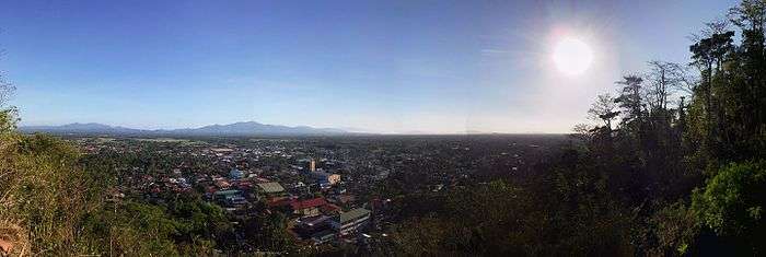
 Downtown area | ||
| ||
Nickname(s):
| ||
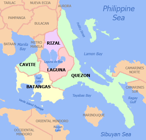
 Map of Batangas with Rosario highlighted | ||
.svg.png) Rosario Location within the Philippines | ||
| Coordinates: 13°50′42″N 121°12′13″E / 13.845°N 121.2036°ECoordinates: 13°50′42″N 121°12′13″E / 13.845°N 121.2036°E | ||
| Country |
| |
| Region | Calabarzon (Region IV-A) | |
| Province | Batangas | |
| District | 4th District | |
| Founded | June 9, 1687 | |
| Barangays | 48 (see Barangays) | |
| Government [2] | ||
| • Type | Sangguniang Bayan | |
| • Mayor | Manuel B. Alvarez | |
| • Vice Mayor | Leovigildo K. Morpe | |
| • Electorate | 66,441 voters (2016) | |
| Area [3] | ||
| • Total | 226.88 km2 (87.60 sq mi) | |
| Population (2015 census)[4] | ||
| • Total | 116,764 | |
| • Density | 510/km2 (1,300/sq mi) | |
| Time zone | UTC+8 (PST) | |
| ZIP code | 4225 | |
| PSGC | 041021000 | |
| IDD : area code | +63 (0)43 | |
| Climate type | Tropical monsoon climate | |
| Income class | 1st municipal income class | |
| Revenue (₱) | 251,988,594.91 (2016) | |
| Native languages | Tagalog | |
| Website |
www | |

Rosario, officially the Municipality of Rosario, (Tagalog: Bayan ng Rosario), is a 1st class municipality in the province of Batangas, Philippines. According to the 2015 census, it has a population of 116,764 people.[4]
Rosario is considered as among the interior municipalities of the Batangas Bay Region comprising eleven municipalities and two cities whose catchment areas drain into the Batangas Bay. The town is also dubbed as "The Rice Granary of Batangas".[1]
History
Accounts show that the origin of Rosario was a Christian settlement along the coast of Lobo. The settlement became prey to the pirate raids during the Moro wars of the 18th century.
The Moro or pirate raids forced the inhabitants of the settlement to the safety of the ravine and forest on the north-west bank of Kansahayan River (now the Municipality of Taysan). Here the settlement was relocated. However, at the height of the Moro Wars in the second half of the 18th century, the vicious Moro raids reached Kansahayan. In one of their forays the Parish Priest is said to be among those slain.
The inhabitants decided to leave Kansahayan. They headed farther north holding a novena and praying the rosary in the process of their flight. On the 9th night of the novena, the fleeing inhabitants reached the river bank of Tubig ng Bayan (a river originating from Lipa) in now the town of Padre Garcia. Here they finally settled. Living in peace and prosperity, the grateful town’s people erected a stone church south of the river bank in honor of their benefactress, the Lady of the Most Holy Rosary Parish. The town was named Santo Rosario.
Santo Rosario was razed to the ground during the Philippine-American War. In the early American military occupation of Santo Rosario, a cavalry officer, Captain Ed H. Boughton, came upon the big spring at the foot of Tombol Hill. He decided to relocate the town west of the spring, where Rosario's population center is now.
Official records show that on June 9, 1902, a council of prominent citizens of the town met under a mango tree beside Tombol Spring. On the spot they formally organized the municipal government of Rosario. The following assumed the first key positions of the town government:
- Geronimo Carandang (Presidente)
- Diego Rosales (Bise Presidente)
- Luis Greñas (Secretario)
- Leon Magtibay (Tesorero)
A wealthy landowner, Don Antonio Luansing donated for the town's public buildings and plaza.
Local historians were not unanimous as the exact date of the founding of this town. Certainly it was among those organized by the ecclesiastical authorities after the creation of Batangas as a province in 1581. It is generally believed to have come to the existence in 1687 while still located along the coast of Lobo during the term of Don Nicolas Morales as gobernadorcillo. Originally, Rosario comprised the whole parts of the municipalities of Lobo, Taysan, Ibaan, San Juan de Bolbok and the entire municipality of Padre Garcia.
The old settlement in Kansayahan now bears the name of Pinagbayanan, a thriving marketing post in the municipality of Taysan. The old town site of Santo Rosario had been named Lumang Bayan before it was renamed Padre Garcia when the latter was created and carved out Rosario in 1950 as a separate municipality.[5]
Geography
Rosario is located at 13°50′42″N 121°12′13″E / 13.845°N 121.2036°E.
According to the Philippine Statistics Authority, the municipality has a land area of 226.88 square kilometres (87.60 sq mi) [3] constituting 7.27% of the 3,119.75-square-kilometre- (1,204.54 sq mi) total area of Batangas.
Barangays
Rosario is politically subdivided into 48 barangays.[6] Malaya was formerly known as Munting Tubig.[7]
| PSGC | Barangay | Population | ±% p.a. | |||
|---|---|---|---|---|---|---|
| 2015[4] | 2010[8] | |||||
| 041021001 | Alupay | 3.7% | 4,314 | 3,991 | 1.49% | |
| 041021002 | Antipolo | 0.6% | 674 | 652 | 0.63% | |
| 041021003 | Bagong Pook | 4.9% | 5,757 | 5,165 | 2.09% | |
| 041021004 | Balibago | 2.0% | 2,280 | 2,147 | 1.15% | |
| 041021005 | Bayawang | 1.1% | 1,307 | 1,332 | −0.36% | |
| 041021006 | Baybayin | 2.0% | 2,323 | 2,288 | 0.29% | |
| 041021007 | Bulihan | 3.4% | 4,014 | 3,253 | 4.08% | |
| 041021008 | Cahigam | 2.1% | 2,450 | 1,907 | 4.89% | |
| 041021009 | Calantas | 1.4% | 1,634 | 1,560 | 0.89% | |
| 041021010 | Colongan | 1.5% | 1,727 | 1,655 | 0.81% | |
| 041021011 | Itlugan | 4.0% | 4,677 | 4,386 | 1.23% | |
| 041021012 | Lumbangan | 1.4% | 1,587 | 1,200 | 5.47% | |
| 041021013 | Maalas‑As | 1.7% | 1,932 | 1,776 | 1.62% | |
| 041021014 | Mabato | 1.5% | 1,794 | 1,660 | 1.49% | |
| 041021015 | Mabunga | 1.6% | 1,838 | 1,713 | 1.35% | |
| 041021016 | Macalamcam A | 0.8% | 959 | 1,058 | −1.85% | |
| 041021017 | Macalamcam B | 1.5% | 1,765 | 1,480 | 3.41% | |
| 041021018 | Malaya | 1.3% | 1,555 | 1,482 | 0.92% | |
| 041021019 | Maligaya | 0.8% | 913 | 790 | 2.79% | |
| 041021020 | Marilag | 2.5% | 2,898 | 2,525 | 2.66% | |
| 041021021 | Masaya | 3.4% | 3,967 | 3,217 | 4.07% | |
| 041021022 | Matamis | 0.5% | 592 | 689 | −2.85% | |
| 041021023 | Mavalor | 1.3% | 1,549 | 1,481 | 0.86% | |
| 041021024 | Mayuro | 2.1% | 2,411 | 2,068 | 2.97% | |
| 041021025 | Namuco | 4.3% | 4,992 | 4,314 | 2.82% | |
| 041021026 | Namunga | 4.5% | 5,276 | 4,785 | 1.88% | |
| 041021027 | Natu | 2.3% | 2,721 | 2,392 | 2.48% | |
| 041021028 | Nasi | 1.8% | 2,048 | 1,925 | 1.19% | |
| 041021029 | Palakpak | 0.7% | 851 | 852 | −0.02% | |
| 041021030 | Pinagsibaan | 2.9% | 3,422 | 2,999 | 2.54% | |
| 041021031 | Barangay A (Poblacion) | 1.0% | 1,122 | 1,082 | 0.69% | |
| 041021032 | Barangay B (Poblacion) | 1.2% | 1,376 | 1,195 | 2.72% | |
| 041021033 | Barangay C (Poblacion) | 0.8% | 943 | 968 | −0.50% | |
| 041021034 | Barangay D (Poblacion) | 0.8% | 932 | 1,039 | −2.05% | |
| 041021035 | Barangay E (Poblacion) | 1.9% | 2,276 | 2,174 | 0.88% | |
| 041021036 | Putingkahoy | 2.4% | 2,811 | 2,612 | 1.41% | |
| 041021037 | Quilib | 3.5% | 4,041 | 3,157 | 4.81% | |
| 041021038 | Salao | 2.0% | 2,303 | 2,121 | 1.58% | |
| 041021039 | San Carlos | 3.2% | 3,771 | 3,345 | 2.31% | |
| 041021040 | San Ignacio | 1.7% | 1,954 | 1,780 | 1.79% | |
| 041021041 | San Isidro | 3.3% | 3,811 | 3,521 | 1.52% | |
| 041021042 | San Jose | 1.8% | 2,075 | 1,874 | 1.96% | |
| 041021043 | San Roque | 3.3% | 3,900 | 3,648 | 1.28% | |
| 041021044 | Santa Cruz | 2.8% | 3,301 | 3,055 | 1.49% | |
| 041021045 | Timbugan | 1.8% | 2,077 | 1,946 | 1.25% | |
| 041021046 | Tiquiwan | 1.5% | 1,736 | 1,654 | 0.93% | |
| 041021047 | Leviste (Tubahan) | 1.5% | 1,753 | 1,656 | 1.09% | |
| 041021048 | Tulos | 2.0% | 2,355 | 1,992 | 3.24% | |
| Total | 116,764 | 105,561 | 1.94% | |||
Clusters
For purposes of community organization and effective delivery of social development projects, the Office for Sustainable Development under supervision of the Office of the Municipal Mayor in 1995, divided the 48 barangays into 8 barangay clusters with 6 member barangays each.[9]
| Cluster | Barangays |
|---|---|
| South East I |
|
| North East II |
|
| East III |
|
| East IV |
|
| Central V |
|
| West Central VI |
|
| East Central VII |
|
| West VIII |
|
This system was patterned after the resolutions traditionally passed by the Sangguniang Bayan as part of its organizational plan following the general elections when new members are elected into office for a new term.
Consequently, the barangay cluster arrangement was adopted and served as the framework for land use development strategies enunciated under the Comprehensive Land Use Plan of Rosario, Batangas for Planning Period 2000-2010 (CLUP).[10]
Demographics
| Population census of Rosario | ||
|---|---|---|
| Year | Pop. | ±% p.a. |
| 1903 | 8,326 | — |
| 1918 | 22,174 | +6.75% |
| 1939 | 34,130 | +2.07% |
| 1948 | 36,020 | +0.60% |
| 1960 | 32,868 | −0.76% |
| 1970 | 42,704 | +2.65% |
| 1975 | 47,298 | +2.07% |
| 1980 | 54,252 | +2.78% |
| 1990 | 66,923 | +2.12% |
| 1995 | 74,976 | +2.15% |
| 2000 | 86,110 | +3.01% |
| 2007 | 95,785 | +1.48% |
| 2010 | 105,561 | +3.60% |
| 2015 | 116,764 | +1.94% |
| Source: Philippine Statistics Authority[4][8][11][12] | ||

In the 2015 census, Rosario had a population of 116,764.[4] The population density was 510 inhabitants per square kilometre (1,300/sq mi).
Government

The current set of municipal officials were elected during the 2010 General Elections and re-elected in 2013; their term is set to expire in 2016.
- Municipal Mayor: Manuel B. Alvarez
- Vice Mayor: Leovigildo K. Morpe
- Sangguniang Bayan members:
- Angelito M. Gulfo
- Anatacio G. Zara
- Angel B. Alvarez, Sr.
- Christopher A. Conti
- Arnold T. Austria
- Ferdinand H. De Veyra
- Marilou M. Villapando-Magdangal
- Aldwin G. Garcia
Immediate Past Municipal officials
The immediate past municipal officials were elected during the 2004 General Elections and their term expired 2007. The mayor was Felipe Marquez who was reelected for his second term during the 2007 General Elections as chief executive of Rosario. The vice mayor is Danilo Alday. Sangguniang Bayan is composed of Angelica Rosales, Leonardo Anyayahan, Sonia Ebite, Adrian Montalbo, Kennedy Laroza, Pedro Andan and Johnny Minas. Sangguniang Kabataan Municipal Federation President is Grace Villar of Brgy. Quilib.
Mayor Felipe Africa Marquez expired October 8, 2011, while in office, due to various complications in his health at Mediatrix Hospital Lipa City.
Notable people
- Jovit Baldivino – Pilipinas Got Talent Season 1 winner
Gallery
_Public_Market.jpg) Rosario Public Market
Rosario Public Market Rosario Night Market
 Hall of Justice
 Batangas Racing Circuit arch in Brgy. Maligaya
 The Our Lady of the Most Holy Rosary Parish
 Holy Family Parish in Brgy. Alupay
 The Our Lady of the Most Holy Rosary, patron of Rosario
 The Grotto
 Tombol Hill
 Risen Christ on top of Tombol Hill
References
- 1 2 Ganzon, Tina (9 Jun 2009). "Batangas hosts 'Sinukmani' festival". ABS-CBN News. ABS-CBN Southern Tagalog. Archived from the original on 10 December 2016. Retrieved 10 December 2016.
- ↑ "Municipality". Quezon City, Philippines: Department of the Interior and Local Government. Retrieved 31 May 2013.
- 1 2 "Province: Batangas". PSGC Interactive. Quezon City, Philippines: Philippine Statistics Authority. Retrieved 12 November 2016.
- 1 2 3 4 5 Census of Population (2015). "Region IV-A (Calabarzon)". Total Population by Province, City, Municipality and Barangay. PSA. Retrieved 20 June 2016.
- ↑ "History of the Municipality of Rosario". Archived from the original on 2012-02-04. Retrieved 2012-01-31.
- ↑ "Municipal: Rosario, Batangas". PSGC Interactive. Quezon City, Philippines: Philippine Statistics Authority. Retrieved 8 January 2016.
- ↑ "An Act Changing the Name of the Barrio of Munting Tubig in the Municipality of Rosario, Province of Batangas, to Malaya". LawPH.com. Retrieved 2011-04-09.
- 1 2 Census of Population and Housing (2010). "Region IV-A (Calabarzon)". Total Population by Province, City, Municipality and Barangay. NSO. Retrieved 29 June 2016.
- ↑ Villar, Rodolfo G.; Quizon, Manuel Luis; Barbosa-Bianzon, Francia (1996). Minimum Basic Needs Baseline Survey Consolidated Report. Municipality of Rosario, Batangas, Philippines.
- ↑ Municipal Land Use Committee; Office of the Municipal Planning and Development Coordinator (June 2000). Comprehensive Land Use Plan of Rosario, Batangas for Planning Period: 2000-2010. Municipality of Rosario, Batangas, Philippines.
- ↑ Censuses of Population (1903–2007). "Region IV-A (Calabarzon)". Table 1. Population Enumerated in Various Censuses by Province/Highly Urbanized City: 1903 to 2007. NSO.
- ↑ "Province of Batangas". Municipality Population Data. Local Water Utilities Administration Research Division. Retrieved 17 December 2016.
External links
| Wikimedia Commons has media related to Rosario, Batangas. |
- Municipality of Rosario Batangas (Unofficial Blog)
- Rosario Batangas Information on BlogSpot
- RosarioBatangas.com
- Barangay Clusters
Places adjacent to Rosario, Batangas | ||||||||||
|---|---|---|---|---|---|---|---|---|---|---|
| ||||||||||