General Emilio Aguinaldo, Cavite
| General Emilio Aguinaldo Bailen | ||
|---|---|---|
| Municipality | ||
| Municipality of General Emilio Aguinaldo | ||
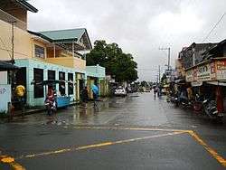 Downtown area | ||
| ||
| Nickname(s): Center for Agro Modernization | ||
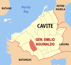 Map of Cavite with General Emilio Aguinaldo highlighted | ||
.svg.png) General Emilio Aguinaldo Location within the Philippines | ||
| Coordinates: 14°11′N 120°48′E / 14.18°N 120.8°ECoordinates: 14°11′N 120°48′E / 14.18°N 120.8°E | ||
| Country |
| |
| Region | Calabarzon (Region IV-A) | |
| Province | Cavite | |
| District | 7th District | |
| Founded | 1858 | |
| Renamed | June 19, 1965 | |
| Named for | Emilio Aguinaldo | |
| Barangays | 14 (see Barangays) | |
| Government [1] | ||
| • Type | Sangguniang Bayan | |
| • Mayor | Danilo Mendoza Bencito | |
| • Vice Mayor | Louel Gloriani Golfo | |
| • Electorate | 13,579 voters (2016) | |
| Area [2] | ||
| • Total | 9.40 km2 (3.63 sq mi) | |
| Population (2015 census)[3] | ||
| • Total | 22,220 | |
| • Density | 2,400/km2 (6,100/sq mi) | |
| Time zone | UTC+8 (PST) | |
| ZIP code | 4124 | |
| PSGC | 042107000 | |
| IDD : area code | +63 (0)46 | |
| Climate type | Tropical monsoon climate | |
| Income class | 5th municipal income class | |
| Revenue (₱) | 59,180,685.94 (2016) | |
| Native languages | Tagalog | |
| Website |
www | |

General Emilio Aguinaldo, officially the Municipality of General Emilio Aguinaldo, (Tagalog: Bayan ng Heneral Emilio Aguinaldo), is a 5th class municipality in the province of Cavite, Philippines. According to the 2015 census, it has a population of 22,220 people.[3]
Formerly known as Bailen, the municipality was named after Emilio Aguinaldo, the president of the First Philippine Republic. The municipality reverted its name to Bailen after the Provincial Board approved Committee Report 118-2012 on September 3, 2012.[4][5] It is however yet to be ratified.
Geography
General Emilio Aguinaldo is located 82 kilometres (51 mi) from Metro Manila. It is bordered to the north and east by the town of Maragondon, by Alfonso to the south, and Magallanes to the west.
Barangays
Bailen is politically subdivided into 14 barangays (4 urban, 10 rural). [2]
- Dalusag
- Batas Dao
- Castaños Cerca
- Castaños Lejos
- Kabulusan
- Kaymisas
- Kaypaaba
- Lumipa
- Narvaez
- Tabora
- Poblacion 1
- Poblacion 2
- Poblacion 3
- Poblacion 4
History
The municipality of General Emilio Aguinaldo used to be a separate Catholic parish in the town of adjacent Maragondon. It was founded by virtue of a decree issued on August 28, 1857 by Archbishop Fray Aranguren, OSA, of the Archdiocese of Manila. The decree separated the barrios of Batas and Guyong-guyong from the town of Maragondon, naming the new parish Bailen. It is recounted that a group of citizens from Barrio Batas petitioned Spanish Governor-General Fernando Norzagaray to convert their barrio into a municipality because of its distance from the town proper. Giving due course to the petition, the Spanish Governor approved the request on August 2, 1858.
Bailen, the town's original name, was coined from the Spanish word "bailar", meaning "to dance". Another claims that it was named after a Spanish town of the same name. The American civil government, from 1899–1901, reduced the number of towns to facilitate the military policy of concentrating the civilian population of the poblaciones. The Philippine Commission approved Act No. 947 on October 15, 1903, annexing the municipalities of Bailen and Mendez to Alfonso, thus becoming barrios of Alfonso. The Philippine Commission, for the second time in 1904, reorganized the entire province of Cavite reducing its 22 municipalities to 9 groups of towns. Bailen was annexed to Mendez. Bailen was reconverted into an independent municipality in 1915, with the complete restoration of peace and order in Cavite.[6]
On June 19, 1965 with the signing of Republic Act no. 4346, the town's name, Bailen, was changed to General Emilio Aguinaldo, in honor of the first Philippine president who died the year before.[7]
On September 3, 2012, the town's name was reverted to Bailen. The Sangguniang Panglalawigan (Provincial Board) has unanimously approved Committee Report 118-2012 renaming General Emilio Aguinaldo, a municipality in the 7th District of the province, to its original, "Bailen" during the 95th Regular Session.[4][5] It is however, yet to be ratified.
Demographics
| Population census of General Emilio Aguinaldo | ||
|---|---|---|
| Year | Pop. | ±% p.a. |
| 1903 | 3,635 | — |
| 1918 | 4,599 | +1.58% |
| 1939 | 5,002 | +0.40% |
| 1948 | 7,301 | +4.29% |
| 1960 | 10,275 | +2.89% |
| 1970 | 8,565 | −1.80% |
| 1975 | 9,571 | +2.25% |
| 1980 | 10,954 | +2.74% |
| 1990 | 10,954 | +0.00% |
| 1995 | 11,893 | +1.55% |
| 2000 | 14,323 | +4.07% |
| 2007 | 17,818 | +3.06% |
| 2010 | 17,507 | −0.64% |
| 2015 | 22,220 | +4.64% |
| Source: Philippine Statistics Authority[3] [8] [9] [10] | ||
In the 2015 census, the population of Gen. Emilio Aguinaldo was 22,220 people,[3] with a density of 2,400 inhabitants per square kilometre or 6,200 inhabitants per square mile.
Local government
The following are the elected officials of the town for the term 2013-2016:
| Position | Official |
|---|---|
| Mayor | Danilo M. Bencito |
| Vice Mayor | Louel G. Golfo |
| Sangguniang Bayan Members |
|---|
| Dennis M. Glean |
| Antonio B. Angat |
| Allan Q. Glean |
| Ricardo B. Mendoza |
| Librado M. Angat |
| Ricardo P. Binauhan |
| Anselmo B. Calingasan |
| Roel M. Gonzales |
| ABC President |
| Rolando P. Mojica |
| SK Federation President |
| Dan Estine M. Mojica |
See also
References
- ↑ "Municipality". Quezon City, Philippines: Department of the Interior and Local Government. Retrieved 31 May 2013.
- 1 2 "Province: Cavite". PSGC Interactive. Quezon City, Philippines: Philippine Statistics Authority. Retrieved 12 November 2016.
- 1 2 3 4 Census of Population (2015). "Region IV-A (Calabarzon)". Total Population by Province, City, Municipality and Barangay. PSA. Retrieved 20 June 2016.
- 1 2 , Yahoo News
- 1 2 "Archived copy". Archived from the original on 2013-11-01. Retrieved 2013-05-09.
- ↑ The Philippine Index, Millennium Edition Vol. 1 No. 1
- ↑ (1965-06-19). "R.A. No. 4346", but in 2012 Cavite provincial board reverts the name of Bailen from Gen. Aguinaldo. PhilippineLaw.info. Retrieved on 2012-05-30.
- ↑ Census of Population and Housing (2010). "Region IV-A (Calabarzon)". Total Population by Province, City, Municipality and Barangay. NSO. Retrieved 29 June 2016.
- ↑ Censuses of Population (1903–2007). "Region IV-A (Calabarzon)". Table 1. Population Enumerated in Various Censuses by Province/Highly Urbanized City: 1903 to 2007. NSO.
- ↑ "Province of Cavite". Municipality Population Data. Local Water Utilities Administration Research Division. Retrieved 17 December 2016.
External links
| Wikimedia Commons has media related to General Emilio Aguinaldo, Cavite. |
- Profile: General Emilio Aguinaldo - Official Website of the Province of Cavite
- Profile: General Emilio Aguinaldo, Cavite - DILG Calabarzon Region
- Philippine Standard Geographic Code
Places adjacent to General Emilio Aguinaldo, Cavite | ||||||||||
|---|---|---|---|---|---|---|---|---|---|---|
| ||||||||||
Trece Martires (de facto capital), Imus (de jure capital) | |
| Municipalities | |
| Component cities | |