Malvar, Batangas
| Malvar | ||
|---|---|---|
| Municipality | ||
| Municipality of Malvar | ||
 | ||
| ||
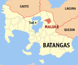 Map of Batangas with Malvar highlighted | ||
.svg.png) Malvar Location within the Philippines | ||
| Coordinates: 14°02′30″N 121°09′30″E / 14.0417°N 121.1583°ECoordinates: 14°02′30″N 121°09′30″E / 14.0417°N 121.1583°E | ||
| Country |
| |
| Region | Calabarzon (Region IV-A) | |
| Province | Batangas | |
| District | 3rd District | |
| Founded | January 10, 1919 | |
| Barangays | 15 (see Barangays) | |
| Government [1] | ||
| • Type | Sangguniang Bayan | |
| • Mayor | Alberto Lat | |
| • Electorate | 29,589 voters (2016) | |
| Area [2] | ||
| • Total | 33.00 km2 (12.74 sq mi) | |
| Elevation | 227 m (745 ft) | |
| Population (2015 census)[3] | ||
| • Total | 56,270 | |
| • Density | 1,700/km2 (4,400/sq mi) | |
| Time zone | UTC+8 (PST) | |
| ZIP code | 4233 | |
| PSGC | 041017000 | |
| IDD : area code | +63 (0)43 | |
| Climate type | Tropical monsoon climate | |
| Income class | 2nd municipal income class | |
| Revenue (₱) | 177,399,918.64 (2016) | |
| Native languages | Tagalog | |
| Website |
www | |

Malvar, officially the Municipality of Malvar, (Tagalog: Bayan ng Malvar), is a 2nd class municipality in the province of Batangas, Philippines. According to the 2015 census, it has a population of 56,270 people.[3]
The municipality was named after General Miguel Malvar, the last Filipino general to surrender to the United States in the Philippines in 1902.
Located 68 kilometres (42 mi) south of Manila and accessible by the STAR Tollway, Malvar is surrounded by Tanauan City to the north, Santo Tomas to the east, Lipa City to the south and Balete to the west. With the expansion of Metro Manila, Malvar is now part of the Manila conurbation (which reaches Lipa City).
Geography
Malvar is located at 14°02′30″N 121°09′30″E / 14.0417°N 121.1583°E.
According to the Philippine Statistics Authority, the municipality has a land area of 33.00 square kilometres (12.74 sq mi) [2] constituting 1.06% of the 3,119.75-square-kilometre- (1,204.54 sq mi) total area of Batangas.
Barangays
Malvar is politically subdivided into 15 barangays.[4]
| PSGC | Barangay | Population | ±% p.a. | |||
|---|---|---|---|---|---|---|
| 2015[3] | 2010[5] | |||||
| 041017001 | Bagong Pook | 3.6% | 2,049 | 1,932 | 1.13% | |
| 041017002 | Bilucao (San Isidro Western) | 3.3% | 1,842 | 1,587 | 2.88% | |
| 041017003 | Bulihan | 4.1% | 2,311 | 1,472 | 8.97% | |
| 041017004 | San Gregorio | 2.4% | 1,336 | 1,138 | 3.10% | |
| 041017005 | Luta del Norte | 7.1% | 3,989 | 3,053 | 5.22% | |
| 041017006 | Luta del Sur | 8.3% | 4,661 | 3,685 | 4.58% | |
| 041017008 | Poblacion | 13.6% | 7,632 | 7,049 | 1.52% | |
| 041017012 | San Andres | 5.5% | 3,074 | 2,869 | 1.32% | |
| 041017013 | San Fernando | 9.7% | 5,446 | 4,349 | 4.38% | |
| 041017015 | San Isidro East | 2.8% | 1,603 | 1,524 | 0.97% | |
| 041017016 | San Juan | 5.5% | 3,069 | 2,907 | 1.04% | |
| 041017017 | San Pedro II (Western) | 3.5% | 1,988 | 1,499 | 5.52% | |
| 041017018 | San Pedro I (Eastern) | 4.4% | 2,448 | 1,681 | 7.42% | |
| 041017019 | San Pioquinto | 12.6% | 7,068 | 5,227 | 5.91% | |
| 041017020 | Santiago | 13.8% | 7,754 | 5,980 | 5.07% | |
| Total | 56,270 | 45,952 | 3.93% | |||
Demographics
| Population census of Malvar | ||
|---|---|---|
| Year | Pop. | ±% p.a. |
| 1939 | 6,637 | — |
| 1948 | 7,787 | +1.79% |
| 1960 | 10,313 | +2.37% |
| 1970 | 14,169 | +3.22% |
| 1975 | 15,584 | +1.93% |
| 1980 | 18,028 | +2.96% |
| 1990 | 24,253 | +3.01% |
| 1995 | 27,771 | +2.57% |
| 2000 | 32,691 | +3.56% |
| 2007 | 41,730 | +3.42% |
| 2010 | 45,952 | +3.57% |
| 2015 | 56,270 | +3.93% |
| Source: Philippine Statistics Authority[3][5][6][7] | ||
In the 2015 census, Malvar had a population of 56,270.[3] The population density was 1,700 inhabitants per square kilometre (4,400/sq mi).
Government
The elected officials for the 2017-2019 term are:
- Mayor: Alberto C. Lat
- Vice Mayor: Matt Louie M. Aranda
- Councilors:
- Karina C. Reyes
- Willy Tagle
- Jovito Dela Peña
- Rachelle Samarita
- Aileen Saludo
- Apollo Endaya
- Federico Basilan
- Lamberto Malabanan (ABC President)
Education
- Bagong Pook Elementary School (Bagong Pook)
- Batangas State University (Poblacion)
- Bilucao Elementary School (Bilucao)
- Bulihan Elementary School(Bulihan)
- Don Julio Leviste Memorial Vocational High School (San Andres)
- Immaculate Conception Montessori School (Poblacion)
- Luta Elementary School (Luta Sur)
- Malvar Central School (Poblacion)
- Malvar National High School (Poblacion)
- Miguel L. Aranda Memorial Elementary School (San Andres)
- OB Montessori School (San Pio Quinto)
- Payapa Elementary School (Santiago)
- San Fernando Elementary School
- San Isidro National High School (San Isidro)
- San Pedro 1 Primary School
- San Pedro Elementary School (San Pedro)
- San Pio Quinto Elementary School (San Pio Quinto)
- Santiago National High School (Santiago)
- Smart Kids Montessori School (Poblacion)
- Southgate Institute of Malvar (Poblacion)
Health
Apart from the primary Rural Health Unit under DOH-Batangas, Mayor Carlito Reyes founded the Malvar Maternity Clinic a month after taking office. The clinic accepts emergency deliveries, and is open 24 hours daily for obstetric and other immediate health services. The clinic has doctors on duty from 7 am to 11 pm weekdays and around the clock on weekends. RHU personnel serve during the day. Nurses are on duty 24 hours daily, and a midwife is on duty weeknights. An ambulance is available for patient transfers, and all services are free of charge.
Attractions
Calejon Falls, in Barangay San Gregorio (formerly known as Calejon), consists of two large waterfalls and two smaller ones. One of the larger falls is about 10 feet (3.0 m) high, with clear water falling into a shallow pool. One of the smaller falls is shower-like, while the other forms a series of small cascades. All the falls are in an area of about 300 square metres (360 sq yd).
The falls are located at the STAR Tollway Bulihan exit. From Manila, buses to Batangas City or Lipa City stop at Malvar. Jeepneys and tricycle service are also available from the town. The 5-kilometre (3.1 mi) stretch of road is smoothly paved. There are 300 concrete steps down the river at the falls.
The San Juan River, the longest river in Batangas, connects Lipa, and Tanauan and Santo Tomas and is a water source for vegetable and fish farms.
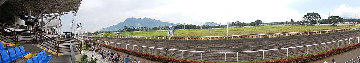
A recently emerged local attraction in the area is a mango farm known as Sa Manggahan.[8] Forty-five minutes away at Alabang, it is near the C-Joist Concrete Ventures Group plant. The country's third Thoroughbred race track (Metro Manila Turf Club Race Track) is nearby, as are the Immaculate Conception Parish Church of Malvar and the Miguel Malvar Shrine. The fiesta occurs every January 10.
Malvar is slowly establishing its reputation as a conference center in Batangas. In February 2013, the Lima Park Pavilion opened to the public with a concert by the Madrigal Singers. With a capacity of 1,000 the Lima Park Pavilion and Lima Park Hotel are located in Malvar's industrial park, the Lima Technology Center.
Landmarks
- Batangas State University Jose P. Laurel Polytechnic College
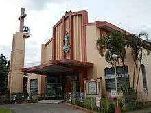
- Immaculate Conception Parish Church of Malvar
- Metro Manila Turf Club Race Track
- Miguel Malvar Shrine
Notable residents
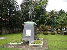
Malvar is named after the Filipino hero Miguel Malvar, a native of Santo Tomas. General Malvar's life was dedicated to defending freedom and democracy for the Filipino people against Spanish and American soldiers. His guerrilla force moved against the Americans from its command post in the mountains of Batangas with the help of local residents who supported the soldiers and provided intelligence.
See also
References
- ↑ "Municipality". Quezon City, Philippines: Department of the Interior and Local Government. Retrieved 31 May 2013.
- 1 2 "Province: Batangas". PSGC Interactive. Quezon City, Philippines: Philippine Statistics Authority. Retrieved 12 November 2016.
- 1 2 3 4 5 Census of Population (2015). "Region IV-A (Calabarzon)". Total Population by Province, City, Municipality and Barangay. PSA. Retrieved 20 June 2016.
- ↑ "Municipal: Malvar, Batangas". PSGC Interactive. Quezon City, Philippines: Philippine Statistics Authority. Retrieved 8 January 2016.
- 1 2 Census of Population and Housing (2010). "Region IV-A (Calabarzon)". Total Population by Province, City, Municipality and Barangay. NSO. Retrieved 29 June 2016.
- ↑ Censuses of Population (1903–2007). "Region IV-A (Calabarzon)". Table 1. Population Enumerated in Various Censuses by Province/Highly Urbanized City: 1903 to 2007. NSO.
- ↑ "Province of Batangas". Municipality Population Data. Local Water Utilities Administration Research Division. Retrieved 17 December 2016.
- ↑ "Sa Manggahan Leisure Farms, Barangay San Pioquinto, Malvar, Batangas". Samanggahan.com. Archived from the original on April 5, 2012. Retrieved 2011-09-27.
External links
| Wikimedia Commons has media related to Malvar, Batangas. |
Places adjacent to Malvar, Batangas | ||||||||||
|---|---|---|---|---|---|---|---|---|---|---|
| ||||||||||
Batangas (capital) | |
| Municipalities | |
| Component cities | |