San Antonio, Quezon
| San Antonio | ||
|---|---|---|
| Municipality | ||
| Municipality of San Antonio | ||
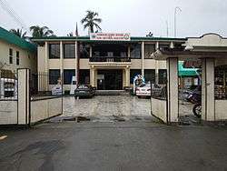
  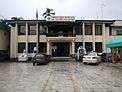 Downtown area, Sacred Heart of Jesus Parish Church, Municipal Hall | ||
| ||
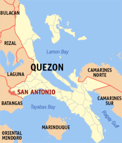 Map of Quezon with San Antonio highlighted | ||
.svg.png) San Antonio Location within the Philippines | ||
| Coordinates: 13°54′N 121°18′E / 13.9°N 121.3°ECoordinates: 13°54′N 121°18′E / 13.9°N 121.3°E | ||
| Country |
| |
| Region | Calabarzon (Region IV-A) | |
| Province | Quezon | |
| District | 2nd District | |
| Founded | October 4, 1957 | |
| Barangays | 20 (see Barangays) | |
| Government [1] | ||
| • Type | Sangguniang Bayan | |
| • Mayor | Erick M. Wagan | |
| • Electorate | 19,632 voters (2016) | |
| Area [2] | ||
| • Total | 172.93 km2 (66.77 sq mi) | |
| Population (2015 census)[3] | ||
| • Total | 33,467 | |
| • Density | 190/km2 (500/sq mi) | |
| Time zone | UTC+8 (PST) | |
| ZIP code | 4324 | |
| PSGC | 045641000 | |
| IDD : area code | +63 (0)42 | |
| Climate type | Tropical rainforest climate | |
| Income class | 4th municipal income class | |
| Revenue (₱) | 81,408,995.46 (2016) | |
| Native languages | Tagalog | |
| Website |
www | |

San Antonio, officially the Municipality of San Antonio, (Tagalog: Bayan ng San Antonio), is a 4th class municipality in the province of Quezon, Philippines. According to the 2015 census, it has a population of 33,467 people.[3]
Located in the westernmost part of the province, it is one of the municipalities that traverses Quezon and Batangas. It has an efficient road system, the National Road linking Tiaong, Quezon and Lipa City through passing Padre Garcia.
It produces bottled Sinturis Juice, pasteurized freshly squeezed Philippine orange mixed with sugar, Malagkit Festival with the different kakanin made from malagkit. It also has several resorts and leisure farms that serve as favorite getaways for fun and family get together.
It is composed of 20 barangays, each headed by a barangay captain and seven councilmen duly elected. It is a third-class municipality having total area of 5,400 hectares.
History
Buliran, which is a barrio of San Antonio, is a progressive one at its western part. Its history is still unknown to many people, which were told by two aged persons by the name of Mrs. Hermogina Quizon and Mr. Venancio Ilagan. According to them this barrio was named Bulihan. When they inhabited the place, they found the place a big area and crowded with tall cogon, talahib and amorsiko grasses, wild vines and giant-like trees along the river. The first people to inhabit the place were from the western part of the place or Batangueño who witnessed the wild animals loitering around. They were also the inhabitants who cultivated the land in spite of the fear they feel when this barrio was inhabited by the outlaws headed by Kolas Igat.[4]
This place which was the hideout of the out - laws was named to belong to "Impierno" based on the killings of the prisoners of Kolas lgat. Kolas Igat and his men frequented the municipalities of San Pablo, Tiaong, Candelaria, San Juan, Padre Garcia and those who did not obey his orders were made prisoners and sentenced to death at "Impierno". Because of the many lives seized by the outlaw leader, the place was called "Buliran".[5]
Then under the administration of Kapitan Pedro Veneracion during the Spanish Regime, he distributed the land to the people. To allure the Batangueños, a road leading to Padre Garcia and Tiaong was opened. Every person who received a piece of land was asked to pay a tax of one peso or to donate free labor for one week in the construction of the road. As expected, the population grew fast and the people established residence along the road. Simeon de Torres, a barrio ruler, was among the inhabitants who have done a lot towards the attainment of peace and prosperity of the place.[6]
Time passed until 1938 when the barrio market was established through the kindness of Mr. Valentin Umali who lent the market site. A bridge was constructed between Niing and Buliran. A school building was constructed also, so with the first Catholic Chapel. In the year 1946, General Andres "Dumas" Umali thought of making Buliran a municipality separate from Tiaong. There were many hindrances as a result of the World War II. Time goes by and the barrio progressed. The barrio lieutenants then of Niing, Buliran, Pury, Behia, Callejon and Matipunso held a meeting and resolved to bring the matter to the Municipal Council of Tiaong through the district Municipal Councilor, Juanito C. Wagan. The municipal council did not approved, however, the resolution. The insistent municipal councilor, then thought of approaching the congressman of the first district of Quezon, Manuel S. Enverga. He was advised to prepare a petition and brought it to the attention of the provincial board. The parish priest Calixto Jamilla, who was among the petitioner, choose the name San Antonio afier the name of a Saint who died on June 13, 1231, because of the miracles he had shown.[7]
At Lucena the, objections were raised. A public hearing was set at the Municipal Hall of Tiaong. The matter was fully deliberated upon, and the reasons for its creation were found satisfactory. The petition then was elevated to Executive Secretary Carlos P. Garcia.[8]
Years passed until the president of the Philippines signed Executive Order Number 270 on October 4, 1957, creating the new municipality of San Antonio. On November 19, 1957, a municipal mayor, vice mayor and six councilmen were appointed who took their oaths of office on November 22, 1957. The first municipal council session was held on November 25, 1957.[9]
Barangays
San Antonio is politically subdivided into 20 barangays.
- Arawan
- Bagong Niing
- Balat Atis
- Briones
- Bulihan
- Buliran
- Callejon
- Corazon
- Del Valle
- Loob
- Magsaysay
- Matipunso
- Niing
- Poblacion
- Pulo
- Pury
- Sampaga
- Sampaguita
- San Jose
- Sinturisan
Demographics
| Population census of San Antonio | ||
|---|---|---|
| Year | Pop. | ±% p.a. |
| 1960 | 9,847 | — |
| 1970 | 14,236 | +3.75% |
| 1975 | 16,204 | +2.63% |
| 1980 | 17,701 | +1.78% |
| 1990 | 20,786 | +1.62% |
| 1995 | 22,933 | +1.86% |
| 2000 | 26,419 | +3.08% |
| 2007 | 30,023 | +1.78% |
| 2010 | 31,681 | +1.98% |
| 2015 | 33,467 | +1.05% |
| Source: Philippine Statistics Authority[3][10][11][12] | ||
Schools
Early Childhood, Preschool
- Bixby Knolls Preparatory Academy, Inc.
Elementary
- Anne Benedectine Montessori
- Arawan Elementary School
- Briones Elementary School
- Bixby Knolls Preparatory Academy, Inc.
- Bulihan Elementary School
- Callejon Elementary School
- Del Valle Elementary School
- Domingo M. Isabedra MES (Loob ES)
- Magsaysay Elementary School
- Matipunso Elementary School
- Niing Elementary School
- Pury Elementary School
- Saint Anne Montessori Learning Center
- Sampaga Elementary School
- San Antonio Central School
- Sintorisan Elementary School
- San Antonio Infotech School
Secondary
- Bixby Knolls Preparatory Academy, Inc.
- Callejon National High School
- ICT-ED Institute of Science and Technology Inc
- Manuel S. Enverga University Foundation
- San Antonio National High School
- Annex San Antonio National High School, San Jose
Tertiary
- ICT-ED Institute of Science and Technology Inc.[13]
- Manuel S. Enverga University Foundation
Tourism
Resorts
- Dela Peña Resort
- Baybay Ilog Resort (Hotel & Restaurant)
- Leachar Resort & Leisure Park
- La Esperanza Resort
- Migos Resort
- Melicia Beach
- Soul Change Cottage Philippines Inc (jingi)
Government Officials
Elected Officials of San Antonio: [14]
| Position | Name |
|---|---|
| Mayor | Erick M. Wagan |
| Vice Mayor | Jay S. Veslino |
| Councilors | |
| Jenny Murphy | |
| Alvin Hiwatig | |
| Carmelo Cuevas | |
| Ronnie Burgos | |
| Edna Perez | |
| Manolito Pentinio | |
| Mario Guce | |
| Allan Sales |
Notable people
- Gary Jason B. Ejercito Estrada, actor, Quezon 2nd district Board Member, and nephew of former President Joseph Ejercito Estrada
- Kiko Ejercito Estrada, actor and son to Cheska Diaz of Gary Ejercito
- Proceso Alcala, former representative of Quezon 2nd District and current Agriculture Secretary
- Juliana Mendoza Cox aka Julie Cox, International Author (I ordered my future Yesterday) with Gold Seal of Literary Excellence, Quezon Medalya ng Karangalan 2014 (QMK), Public Service- medical missions, feeding programs and random acts of kindness. GED Awardee - Government Equivalency Diploma in Bergen Community College, New Jersey, USA, Ellis Island Wall of Honor in New York. Chairperson (2014) San Antonio Quezon Tourism Council (jingi)
References
- ↑ "Municipality". Quezon City, Philippines: Department of the Interior and Local Government. Retrieved 31 May 2013.
- ↑ "Province: Quezon". PSGC Interactive. Quezon City, Philippines: Philippine Statistics Authority. Retrieved 12 November 2016.
- 1 2 3 Census of Population (2015). "Region IV-A (Calabarzon)". Total Population by Province, City, Municipality and Barangay. PSA. Retrieved 20 June 2016.
- ↑ "History of San Antonio, Quezon". San Antonio, Quezon. Retrieved 2015-11-22.
- ↑ "History of San Antonio, Quezon". San Antonio, Quezon. Retrieved 2015-11-22.
- ↑ "History of San Antonio, Quezon". San Antonio, Quezon. Retrieved 2015-11-22.
- ↑ "History of San Antonio, Quezon". San Antonio, Quezon. Retrieved 2015-11-22.
- ↑ "History of San Antonio, Quezon". San Antonio, Quezon. Retrieved 2015-11-22.
- ↑ "History of San Antonio, Quezon". San Antonio, Quezon. Retrieved 2015-11-22.
- ↑ Census of Population and Housing (2010). "Region IV-A (Calabarzon)". Total Population by Province, City, Municipality and Barangay. NSO. Retrieved 29 June 2016.
- ↑ Censuses of Population (1903–2007). "Region IV-A (Calabarzon)". Table 1. Population Enumerated in Various Censuses by Province/Highly Urbanized City: 1903 to 2007. NSO.
- ↑ "Province of Quezon". Municipality Population Data. Local Water Utilities Administration Research Division. Retrieved 17 December 2016.
- ↑ ICT-ED Institute of Science and Technology
- ↑ "Elected Officials of San Antonio". DILG.
External links
| Wikimedia Commons has media related to San Antonio, Quezon. |
- Philippine Standard Geographic Code
- Philippine Census Information
- Local Governance Performance Management System
- http://www.sanantonio-quezon.webs.com
Places adjacent to San Antonio, Quezon | |
|---|---|
Lucena (capital) | |
| Municipalities |
|
| Component city | |
| Highly urbanized city |
|