Taysan, Batangas
| Taysan | ||
|---|---|---|
| Municipality | ||
| Municipality of Taysan | ||
 | ||
| ||
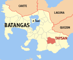 Map of Batangas with Taysan highlighted | ||
.svg.png) Taysan Location within the Philippines | ||
| Coordinates: 13°47′N 121°12′E / 13.78°N 121.2°ECoordinates: 13°47′N 121°12′E / 13.78°N 121.2°E | ||
| Country |
| |
| Region | Calabarzon (Region IV-A) | |
| Province | Batangas | |
| District | 4th District | |
| Founded | April 24, 1919 [1] | |
| Barangays | 20 (see Barangays) | |
| Government [2] | ||
| • Type | Sangguniang Bayan | |
| • Mayor | Grande P. Gutierrez | |
| • Electorate | 23,278 voters (2016) | |
| Area [3] | ||
| • Total | 93.62 km2 (36.15 sq mi) | |
| Population (2015 census)[4] | ||
| • Total | 38,007 | |
| • Density | 410/km2 (1,100/sq mi) | |
| Time zone | UTC+8 (PST) | |
| ZIP code | 4228 | |
| PSGC | 041032000 | |
| IDD : area code | +63 (0)43 | |
| Climate type | Tropical monsoon climate | |
| Income class | 2nd municipal income class | |
| Revenue (₱) | 111,865,154.98 (2016) | |
| Native languages | Tagalog | |

Taysan, officially the Municipality of Taysan, (Tagalog: Bayan ng Taysan), is a 2nd class municipality in the province of Batangas, Philippines. According to the 2015 census, it has a population of 38,007 people.[4]
Geography
Taysan is located at 13°47′N 121°12′E / 13.78°N 121.2°E.
According to the Philippine Statistics Authority, the municipality has a land area of 93.62 square kilometres (36.15 sq mi) [3] constituting 3.00% of the 3,119.75-square-kilometre- (1,204.54 sq mi) total area of Batangas.
Taysan is bordered on the north by Rosario and Ibaan, east by a portion of Rosario, west by Batangas City, and south by Lobo.
Barangays
Taysan is politically subdivided into 20 barangays.[5]
| PSGC | Barangay | Population | ±% p.a. | |||
|---|---|---|---|---|---|---|
| 2015[4] | 2010[6] | |||||
| 041032001 | Bacao | 2.4% | 918 | 970 | −1.04% | |
| 041032002 | Bilogo | 5.9% | 2,252 | 2,070 | 1.62% | |
| 041032003 | Bukal | 4.1% | 1,554 | 1,448 | 1.35% | |
| 041032004 | Dagatan | 8.1% | 3,078 | 2,667 | 2.77% | |
| 041032005 | Guinhawa | 3.5% | 1,327 | 1,194 | 2.03% | |
| 041032006 | Laurel | 4.6% | 1,739 | 1,658 | 0.91% | |
| 041032007 | Mabayabas | 6.0% | 2,264 | 2,072 | 1.70% | |
| 041032008 | Mahanadiong | 5.0% | 1,908 | 1,741 | 1.76% | |
| 041032009 | Mapulo | 8.1% | 3,084 | 2,850 | 1.51% | |
| 041032010 | Mataas na Lupa | 3.8% | 1,452 | 1,540 | −1.11% | |
| 041032011 | Pag‑Asa | 6.5% | 2,468 | 2,293 | 1.41% | |
| 041032012 | Panghayaan | 3.4% | 1,286 | 1,230 | 0.85% | |
| 041032013 | Piña | 4.0% | 1,525 | 1,462 | 0.81% | |
| 041032014 | Pinagbayanan | 6.9% | 2,625 | 2,310 | 2.46% | |
| 041032015 | Poblacion East | 2.2% | 846 | 818 | 0.64% | |
| 041032016 | Poblacion West | 2.6% | 976 | 901 | 1.53% | |
| 041032017 | San Isidro | 6.8% | 2,581 | 2,401 | 1.39% | |
| 041032018 | San Marcelino | 4.8% | 1,807 | 1,700 | 1.17% | |
| 041032019 | Santo Niño | 6.6% | 2,501 | 2,303 | 1.58% | |
| 041032020 | Tilambo | 4.8% | 1,816 | 1,729 | 0.94% | |
| Total | 38,007 | 35,357 | 1.39% | |||
Demographics
| Population census of Taysan | ||
|---|---|---|
| Year | Pop. | ±% p.a. |
| 1903 | 3,386 | — |
| 1939 | 8,526 | +2.60% |
| 1948 | 10,318 | +2.14% |
| 1960 | 11,750 | +1.09% |
| 1970 | 14,999 | +2.47% |
| 1975 | 17,075 | +2.63% |
| 1980 | 19,370 | +2.55% |
| 1990 | 22,508 | +1.51% |
| 1995 | 26,504 | +3.11% |
| 2000 | 29,836 | +2.57% |
| 2007 | 33,454 | +1.59% |
| 2010 | 35,357 | +2.03% |
| 2015 | 38,007 | +1.39% |
| Source: Philippine Statistics Authority[4][6][7][8] | ||
In the 2015 census, Taysan had a population of 38,007.[4] The population density was 410 inhabitants per square kilometre (1,100/sq mi).
Gallery
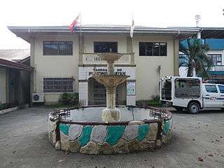 Municipal hall
 Public market
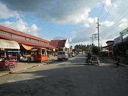
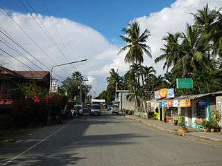 A street in town
 Nuestra Señora dela Merced Parish Church
References
- ↑ https://m.facebook.com/story.php?story_fbid=974632679227638&id=100000427454000
- ↑ "Municipality". Quezon City, Philippines: Department of the Interior and Local Government. Retrieved 31 May 2013.
- 1 2 "Province: Batangas". PSGC Interactive. Quezon City, Philippines: Philippine Statistics Authority. Retrieved 12 November 2016.
- 1 2 3 4 5 Census of Population (2015). "Region IV-A (Calabarzon)". Total Population by Province, City, Municipality and Barangay. PSA. Retrieved 20 June 2016.
- ↑ "Municipal: Taysan, Batangas". PSGC Interactive. Quezon City, Philippines: Philippine Statistics Authority. Retrieved 8 January 2016.
- 1 2 Census of Population and Housing (2010). "Region IV-A (Calabarzon)". Total Population by Province, City, Municipality and Barangay. NSO. Retrieved 29 June 2016.
- ↑ Censuses of Population (1903–2007). "Region IV-A (Calabarzon)". Table 1. Population Enumerated in Various Censuses by Province/Highly Urbanized City: 1903 to 2007. NSO.
- ↑ "Province of Batangas". Municipality Population Data. Local Water Utilities Administration Research Division. Retrieved 17 December 2016.
External links
| Wikimedia Commons has media related to Taysan, Batangas. |
Places adjacent to Taysan, Batangas | ||||||||||
|---|---|---|---|---|---|---|---|---|---|---|
| ||||||||||
Batangas (capital) | |
| Municipalities | |
| Component cities | |