Santa Teresita, Batangas
| Santa Teresita | ||
|---|---|---|
| Municipality | ||
| Municipality of Santa Teresita | ||
 | ||
| ||
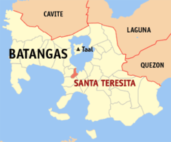 Map of Batangas with Santa Teresita highlighted | ||
.svg.png) Santa Teresita Location within the Philippines | ||
| Coordinates: 13°53′N 120°58′E / 13.88°N 120.97°ECoordinates: 13°53′N 120°58′E / 13.88°N 120.97°E | ||
| Country |
| |
| Region | Calabarzon (Region IV-A) | |
| Province | Batangas | |
| District | 3rd District | |
| Founded | December 28 1961 [1] | |
| Barangays | 17 (see Barangays) | |
| Government [2] | ||
| • Type | Sangguniang Bayan | |
| • Mayor | Aurea V. Segunial | |
| • Electorate | 12,630 voters (2016) | |
| Area [3] | ||
| • Total | 16.30 km2 (6.29 sq mi) | |
| Population (2015 census)[4] | ||
| • Total | 21,127 | |
| • Density | 1,300/km2 (3,400/sq mi) | |
| Time zone | UTC+8 (PST) | |
| ZIP code | 4206 | |
| PSGC | 041027000 | |
| IDD : area code | +63 (0)43 | |
| Climate type | Tropical monsoon climate | |
| Income class | 5th municipal income class | |
| Revenue (₱) | 66,358,081.18 (2016) | |
| Native languages | Tagalog | |

Santa Teresita, officially the Municipality of Santa Teresita, (Tagalog: Bayan ng Santa Teresita), is a 5th class municipality in the province of Batangas, Philippines. According to the 2015 census, it has a population of 21,127 people.[4]
Geography
Santa Teresita is located at 13°53′N 120°58′E / 13.88°N 120.97°E along the southern lakeshore area of Taal Lake. Its boundaries are San Nicolas in the north, San Luis on the south, Taal on the west and Taal Lake on the northeast.
According to the Philippine Statistics Authority, the municipality has a land area of 16.30 square kilometres (6.29 sq mi) [3] constituting 0.52% of the 3,119.75-square-kilometre- (1,204.54 sq mi) total area of Batangas.
Barangays
Santa Teresita is politically subdivided into 17 barangays, with 3 classified as urban and 14 as rural[5]
| PSGC | Barangay | Population | ±% p.a. | |||
|---|---|---|---|---|---|---|
| 2015[4] | 2010[6] | |||||
| 041027001 | Antipolo | 3.6% | 768 | 696 | 1.89% | |
| 041027002 | Bihis | 7.5% | 1,584 | 1,373 | 2.76% | |
| 041027003 | Burol | 3.2% | 667 | 454 | 7.60% | |
| 041027004 | Calayaan | 9.8% | 2,060 | 1,902 | 1.53% | |
| 041027005 | Calumala | 6.4% | 1,346 | 1,289 | 0.83% | |
| 041027006 | Cuta East | 5.6% | 1,185 | 991 | 3.46% | |
| 041027007 | Cutang Cawayan | 3.5% | 733 | 510 | 7.15% | |
| 041027008 | Irukan | 3.0% | 637 | 598 | 1.21% | |
| 041027009 | Pacifico | 9.2% | 1,945 | 1,680 | 2.83% | |
| 041027010 | Poblacion I | 7.9% | 1,662 | 1,483 | 2.19% | |
| 041027012 | Saimsim | 12.9% | 2,730 | 1,910 | 7.04% | |
| 041027013 | Sampa | 6.1% | 1,295 | 1,172 | 1.92% | |
| 041027014 | Sinipian | 4.3% | 898 | 705 | 4.72% | |
| 041027015 | Tambo Ibaba | 4.6% | 976 | 683 | 7.03% | |
| 041027016 | Tambo Ilaya | 4.4% | 920 | 580 | 9.18% | |
| 041027017 | Poblacion II | 5.6% | 1,180 | 986 | 3.48% | |
| 041027018 | Poblacion III | 2.6% | 541 | 403 | 5.77% | |
| Total | 21,127 | 17,415 | 3.75% | |||
Demographics
| Population census of Santa Teresita | ||
|---|---|---|
| Year | Pop. | ±% p.a. |
| 1970 | 9,336 | — |
| 1975 | 10,087 | +1.56% |
| 1980 | 11,134 | +1.99% |
| 1990 | 12,005 | +0.76% |
| 1995 | 14,017 | +2.95% |
| 2000 | 14,074 | +0.09% |
| 2007 | 16,891 | +2.55% |
| 2010 | 17,415 | +1.12% |
| 2015 | 21,127 | +3.75% |
| Source: Philippine Statistics Authority[4][6][7][8] | ||
In the 2015 census, Santa Teresita had a population of 21,127.[4] The population density was 1,300 inhabitants per square kilometre (3,400/sq mi).
Gallery
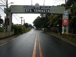 Welcome arch
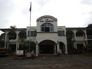 Municipal hall
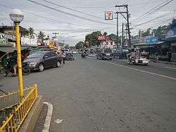
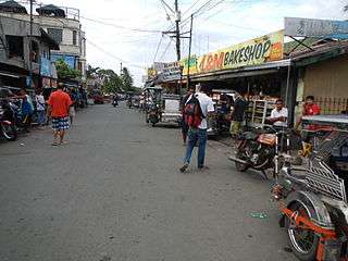 Downtown
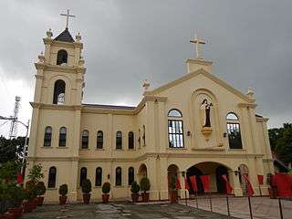 Archdiocesan Shrine of Saint Therese of the Child Jesus and of the Holy Face
References
- ↑ http://www.officialgazette.gov.ph/1961/12/28/executive-order-no-454-s-1961/
- ↑ "Municipality". Quezon City, Philippines: Department of the Interior and Local Government. Retrieved 31 May 2013.
- 1 2 "Province: Batangas". PSGC Interactive. Quezon City, Philippines: Philippine Statistics Authority. Retrieved 12 November 2016.
- 1 2 3 4 5 Census of Population (2015). "Region IV-A (Calabarzon)". Total Population by Province, City, Municipality and Barangay. PSA. Retrieved 20 June 2016.
- ↑ "Municipal: Santa Teresita, Batangas". PSGC Interactive. Quezon City, Philippines: Philippine Statistics Authority. Retrieved 8 January 2016.
- 1 2 Census of Population and Housing (2010). "Region IV-A (Calabarzon)". Total Population by Province, City, Municipality and Barangay. NSO. Retrieved 29 June 2016.
- ↑ Censuses of Population (1903–2007). "Region IV-A (Calabarzon)". Table 1. Population Enumerated in Various Censuses by Province/Highly Urbanized City: 1903 to 2007. NSO.
- ↑ "Province of Batangas". Municipality Population Data. Local Water Utilities Administration Research Division. Retrieved 17 December 2016.
External links
| Wikimedia Commons has media related to Santa Teresita, Batangas. |
Places adjacent to Santa Teresita, Batangas | ||||||||||
|---|---|---|---|---|---|---|---|---|---|---|
| ||||||||||
Batangas (capital) | |
| Municipalities | |
| Component cities | |