San Narciso, Quezon
| San Narciso | |
|---|---|
| Municipality | |
| Municipality of San Narciso | |
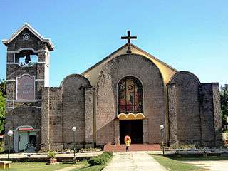 San Narciso Church | |
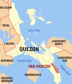 Map of Quezon with San Narciso highlighted | |
.svg.png) San Narciso Location within the Philippines | |
| Coordinates: 13°34′12″N 122°33′54″E / 13.57°N 122.565°ECoordinates: 13°34′12″N 122°33′54″E / 13.57°N 122.565°E | |
| Country |
|
| Region | Calabarzon (Region IV-A) |
| Province | Quezon |
| District | 3rd District |
| Founded | February 2, 1846 [1] |
| Barangays | 24 (see Barangays) |
| Government [2] | |
| • Type | Sangguniang Bayan |
| • Mayor | Pobel Uy-Yap |
| • Vice Mayor | Baby Babao |
| • Electorate | 24,869 voters (2016) |
| Area [3] | |
| • Total | 263.58 km2 (101.77 sq mi) |
| Population (2015 census)[4] | |
| • Total | 48,461 |
| • Density | 180/km2 (480/sq mi) |
| Time zone | UTC+8 (PST) |
| ZIP code | 4313 |
| PSGC | 045644000 |
| IDD : area code | +63 (0)42 |
| Climate type | Tropical rainforest climate |
| Income class | 3rd municipal income class |
| Revenue (₱) | 125,711,643.45 (2016) |
| Native languages | Tagalog |
| Website |
www |
San Narciso, officially the Municipality of San Narciso, (Tagalog: Bayan ng San Narciso), is a 3rd class municipality in the province of Quezon, Philippines. According to the 2015 census, it has a population of 48,461 people.[4]
Barangays
San Narciso has 24 barangays, 4 in Poblacion area.
- Abuyon
- Andres Bonifacio
- Bani
- Binay
- Buenavista
- Busokbusokan
- Calwit
- Guinhalinan
- Lakdayan
- Maguiting
- Manlampong
- Pagkakaisa (Poblacion)
- Maligaya (Poblacion)
- Bayanihan (Poblacion)
- Pagdadamayan (Poblacion)
- Punta
- Rizal
- San Isidro
- San Juan
- San Vicente
- Vigo Central
- Villa Aurin (Pinagsama)
- Villa Reyes
- White Cliff
Demographics
| Population census of San Narciso | ||
|---|---|---|
| Year | Pop. | ±% p.a. |
| 1903 | 2,501 | — |
| 1918 | 2,752 | +0.64% |
| 1939 | 5,683 | +3.51% |
| 1948 | 7,006 | +2.35% |
| 1960 | 7,877 | +0.98% |
| 1970 | 17,876 | +8.53% |
| 1975 | 24,556 | +6.57% |
| 1980 | 28,958 | +3.35% |
| 1990 | 33,025 | +1.32% |
| 1995 | 36,535 | +1.91% |
| 2000 | 38,474 | +1.11% |
| 2007 | 39,828 | +0.48% |
| 2010 | 45,386 | +4.87% |
| 2015 | 48,461 | +1.26% |
| Source: Philippine Statistics Authority[4][5][6][7] | ||
Local government
- Mayor: Eleanor "Allen" Umali Uy
- Vice Mayor: Raymond Nonnatus Rocha Medenilla
References
- ↑ https://m.facebook.com/story.php?story_fbid=1211597668955223&id=10000310032131
- ↑ "Municipality". Quezon City, Philippines: Department of the Interior and Local Government. Retrieved 31 May 2013.
- ↑ "Province: Quezon". PSGC Interactive. Quezon City, Philippines: Philippine Statistics Authority. Retrieved 12 November 2016.
- 1 2 3 Census of Population (2015). "Region IV-A (Calabarzon)". Total Population by Province, City, Municipality and Barangay. PSA. Retrieved 20 June 2016.
- ↑ Census of Population and Housing (2010). "Region IV-A (Calabarzon)". Total Population by Province, City, Municipality and Barangay. NSO. Retrieved 29 June 2016.
- ↑ Censuses of Population (1903–2007). "Region IV-A (Calabarzon)". Table 1. Population Enumerated in Various Censuses by Province/Highly Urbanized City: 1903 to 2007. NSO.
- ↑ "Province of Quezon". Municipality Population Data. Local Water Utilities Administration Research Division. Retrieved 17 December 2016.
External links
- Philippine Standard Geographic Code
- Philippine Census Information
- Local Governance Performance Management System
Places adjacent to San Narciso, Quezon | |
|---|---|
Lucena (capital) | |
| Municipalities |
|
| Component city | |
| Highly urbanized city |
|
| Authority control |
|---|
This article is issued from
Wikipedia.
The text is licensed under Creative Commons - Attribution - Sharealike.
Additional terms may apply for the media files.