Lian, Batangas
| Lian | ||
|---|---|---|
| Municipality | ||
| Municipality of Lian | ||
 | ||
| ||
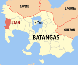 Map of Batangas with Lian highlighted | ||
.svg.png) Lian Location within the Philippines | ||
| Coordinates: 14°02′N 120°39′E / 14.03°N 120.65°ECoordinates: 14°02′N 120°39′E / 14.03°N 120.65°E | ||
| Country |
| |
| Region | Calabarzon (Region IV-A) | |
| Province | Batangas | |
| District | 1st District | |
| Founded | January 31, 1915 [1] | |
| Barangays | 19 (see Barangays) | |
| Government [2] | ||
| • Type | Sangguniang Bayan | |
| • Mayor | Isagani Ilagan Bolompo | |
| • Electorate | 32,446 voters (2016) | |
| Area [3] | ||
| • Total | 76.80 km2 (29.65 sq mi) | |
| Population (2015 census)[4] | ||
| • Total | 52,660 | |
| • Density | 690/km2 (1,800/sq mi) | |
| Time zone | UTC+8 (PST) | |
| ZIP code | 4216 | |
| PSGC | 041013000 | |
| IDD : area code | +63 (0)43 | |
| Climate type | Tropical monsoon climate | |
| Income class | 3rd municipal income class | |
| Revenue (₱) | 119,010,911.47 (2016) | |
| Native languages | Tagalog | |
| Website |
www | |

Lian, officially the Municipality of Lian, (Tagalog: Bayan ng Lian), is a 3rd class municipality in the province of Batangas, Philippines. According to the 2015 census, it has a population of 52,660 people.[4]
The patron saint of Lian is John the Baptist.
Geography
Lian is located at 14°02′N 120°39′E / 14.03°N 120.65°E.
According to the Philippine Statistics Authority, the municipality has a land area of 76.80 square kilometres (29.65 sq mi) [3] constituting 2.46% of the 3,119.75-square-kilometre- (1,204.54 sq mi) total area of Batangas.
Barangays
Lian is politically subdivided into 19 barangays.[5]
| PSGC | Barangay | Population | ±% p.a. | |||
|---|---|---|---|---|---|---|
| 2015[4] | 2010[6] | |||||
| 041013002 | Bagong Pook | 4.4% | 2,321 | 2,011 | 2.77% | |
| 041013003 | Balibago | 6.2% | 3,250 | 2,964 | 1.77% | |
| 041013004 | Binubusan | 8.8% | 4,610 | 4,061 | 2.44% | |
| 041013005 | Bungahan | 8.1% | 4,249 | 3,415 | 4.25% | |
| 041013007 | Cumba | 3.3% | 1,724 | 1,487 | 2.86% | |
| 041013008 | Humayingan | 3.0% | 1,557 | 1,328 | 3.08% | |
| 041013009 | Kapito | 6.2% | 3,273 | 2,764 | 3.27% | |
| 041013012 | Lumaniag | 4.4% | 2,309 | 2,114 | 1.69% | |
| 041013013 | Luyahan | 4.5% | 2,392 | 2,251 | 1.16% | |
| 041013014 | Malaruhatan | 8.4% | 4,410 | 3,322 | 5.54% | |
| 041013015 | Matabungkay | 9.4% | 4,938 | 4,389 | 2.27% | |
| 041013016 | Barangay 1 (Poblacion) | 3.6% | 1,895 | 1,598 | 3.30% | |
| 041013017 | Barangay 2 (Poblacion) | 1.8% | 928 | 514 | 11.91% | |
| 041013018 | Barangay 3 (Poblacion) | 2.7% | 1,411 | 1,413 | −0.03% | |
| 041013019 | Barangay 4 (Poblacion) | 2.8% | 1,463 | 1,330 | 1.83% | |
| 041013020 | Barangay 5 (Poblacion) | 2.0% | 1,056 | 1,221 | −2.73% | |
| 041013021 | Prenza | 8.5% | 4,486 | 4,070 | 1.87% | |
| 041013022 | Puting‑Kahoy | 3.6% | 1,905 | 1,707 | 2.11% | |
| 041013023 | San Diego | 8.5% | 4,483 | 3,984 | 2.27% | |
| Total | 52,660 | 45,943 | 2.63% | |||
Climate
The climate of Lian falls under the first type of classification, Type I, characterized by two pronounced seasons: Dry season from November to April and wet season for the rest of the year.
Demographics
| Population census of Lian | ||
|---|---|---|
| Year | Pop. | ±% p.a. |
| 1903 | 2,552 | — |
| 1918 | 5,104 | +4.73% |
| 1939 | 8,181 | +2.27% |
| 1948 | 10,702 | +3.03% |
| 1960 | 13,658 | +2.05% |
| 1970 | 20,624 | +4.20% |
| 1975 | 23,271 | +2.45% |
| 1980 | 26,091 | +2.31% |
| 1990 | 31,296 | +1.84% |
| 1995 | 36,000 | +2.66% |
| 2000 | 39,129 | +1.80% |
| 2007 | 44,925 | +1.92% |
| 2010 | 45,943 | +0.82% |
| 2015 | 52,660 | +2.63% |
| Source: Philippine Statistics Authority[4][6][7][8] | ||
In the 2015 census, Lian had a population of 52,660.[4] The population density was 690 inhabitants per square kilometre (1,800/sq mi).
Government
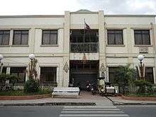
Current Officials as of 2013 elections:
- Mayor: Isagani I. Bolompo
- Vice Mayor: Exequiel "Exy" Bonuan
- Councilors:3
- Leo Malinay
- Florante "Jun-Jun" Lagus Jr.
- Ben Magbago
- Tomas Delos Reyes
- Erwin Austria
- Leo Jonson
- Roland Magyaya
- Jaime "Jimmy" delos Reyes
Education

- Binubusan Christian Faith Learning Center
- Grand Prairie Learning School
- Lian Institute
- Lian National High school
- Matabungkay National High School
- R. B Concepcion Montessori School
- Saint Anne Academy (formerly known as Binubusan Academy)
- Saint Claire Academy
Tourism
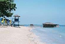

- Matabungkay Beach – a white sand beach accessible to Manila 120 kilometres (75 mi) that was originally 'discovered' to be a great weekend or daytrip destination in the early 1950s, allegedly by sun starved German residents of Manila. It was soon a popular target for holiday-lovers, and permanent cottages (even deluxe beach houses) were built along the beach in the early 1960s by rich Manila folk.
- Town fiesta – Lian's fiesta is held annually every June 24 to commemorate the birthdate of Saint John The Baptist. It is being celebrated by five barangays in the Poblacion, Sitio Bag-bag, also celebrates its fiesta on this day because of its proximity to the town center than to its respective barangays, Kapito and Bungahan (Sitio Bag-bag is shared by 2 barangays).
- Balsa festival – The quaint barangay of Matabungkay is known for its wide beach, clear waters, creamy sand and the Balsa (bamboo beach raft). Every year, this small town comes alive in colorful celebrations as Matabungkay Beach Resort & Hotel hosts the Balsa Festival. The first ever Balsa Festival was held on 18 May 2002, aimed to help the local community by bringing back the town's popularity in the tourism map. With the continued support of the Department of Tourism, the Balsa Festival has become an annual event. Activities include the Balsa Race Competition, Balsa Decor and Cultural Dance Competition, a concert and dance party by the beach, prominent media personalities and foreign executives.
References
- ↑ https://m.facebook.com/groups/241285489403559?view=permalink&id=437244686474304
- ↑ "Municipality". Quezon City, Philippines: Department of the Interior and Local Government. Retrieved 31 May 2013.
- 1 2 "Province: Batangas". PSGC Interactive. Quezon City, Philippines: Philippine Statistics Authority. Retrieved 12 November 2016.
- 1 2 3 4 5 Census of Population (2015). "Region IV-A (Calabarzon)". Total Population by Province, City, Municipality and Barangay. PSA. Retrieved 20 June 2016.
- ↑ "Municipal: Lian, Batangas". PSGC Interactive. Quezon City, Philippines: Philippine Statistics Authority. Retrieved 8 January 2016.
- 1 2 Census of Population and Housing (2010). "Region IV-A (Calabarzon)". Total Population by Province, City, Municipality and Barangay. NSO. Retrieved 29 June 2016.
- ↑ Censuses of Population (1903–2007). "Region IV-A (Calabarzon)". Table 1. Population Enumerated in Various Censuses by Province/Highly Urbanized City: 1903 to 2007. NSO.
- ↑ "Province of Batangas". Municipality Population Data. Local Water Utilities Administration Research Division. Retrieved 17 December 2016.
External links
| Wikimedia Commons has media related to Lian, Batangas. |
| Wikivoyage has a travel guide for Lian. |
Places adjacent to Lian, Batangas | |
|---|---|
Batangas (capital) | |
| Municipalities | |
| Component cities | |