Rizal, Laguna
| Rizal | ||
|---|---|---|
| Municipality | ||
| Municipality of Rizal | ||
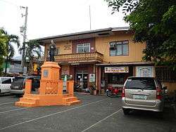 Municipal Hall with statue of José Rizal | ||
| ||
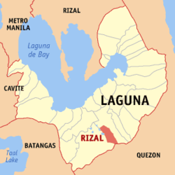 Map of Laguna with Rizal highlighted | ||
.svg.png) Rizal Location within the Philippines | ||
| Coordinates: 14°06′30″N 121°23′30″E / 14.1083°N 121.3917°ECoordinates: 14°06′30″N 121°23′30″E / 14.1083°N 121.3917°E | ||
| Country |
| |
| Region | Calabarzon (Region IV-A) | |
| Province | Laguna | |
| District | 3rd District | |
| Founded | January 7, 1919 | |
| Named for | Dr. José Rizal | |
| Barangays | 11 (see Barangays) | |
| Government [1] | ||
| • Type | Sangguniang Bayan | |
| • Mayor | Antonino A. Aurelio | |
| • Electorate | 11,615 voters (2016) | |
| Area [2] | ||
| • Total | 27.90 km2 (10.77 sq mi) | |
| Population (2015 census)[3] | ||
| • Total | 17,253 | |
| • Density | 620/km2 (1,600/sq mi) | |
| Time zone | UTC+8 (PST) | |
| ZIP code | 4003 | |
| PSGC | 043423000 | |
| IDD : area code | +63 (0)49 | |
| Climate type | Tropical monsoon climate | |
| Income class | 5th municipal income class | |
| Revenue (₱) | 56,192,067.56 (2016) | |
| Native languages | Tagalog | |

Rizal, officially the Municipality of Rizal, (Tagalog: Bayan ng Rizal), is a 5th class municipality in the province of Laguna, Philippines. According to the 2015 census, it has a population of 17,253 people.[3]
The municipality, named after the country's national hero José Rizal, is one of the youngest municipalities in Laguna.
This town is the birthplace of the milky mixed vegetable dish called "amenudong gulay". The people from this town have an old tradition of celebrating Christmas on January 6. There was also a legend of Michael the Archangel apparitions at the town's biggest natural spring "Bukal ni San Miguel" during the Spanish era, making St. Michael the town's patron saint.
Rizal is the hometown of Filipina actress-politician Angelica Jones.
Geography
It is a landlocked municipality located 25 kilometres (16 mi) from the provincial capital Santa Cruz and is bounded on the north by municipality of Calauan, on the east by Nagcarlan, on the west by San Pablo City, and on the south by Dolores, Quezon.
Located amidst coconut trees, Rizal is surrounded by the foothills of Mount San Cristobal, Mount Banahaw, and the Basilin Hill.
Barangays
Rizal is politically subdivided into 11 barangays. [2]
- Antipolo
- Entablado
- Laguan
- Pauli 1
- Pauli 2
- East Poblacion
- West Poblacion
- Pook
- Tala
- Talaga
- Tuy
History
The kaingineros were among the first reported settlers in this part of Laguna around the 17th century. Around mid-1800, this village was called barrio "Pauli" and was part of the town of Nagcarlan.
Residents from this village used to say that the barrio "Pauli" got its name from the way that its brook flows at the edge of the settlement, whose stream flows back and forth. “Pauli,” must have come from the Tagalog word “Pauli-uli,” which means back and forth.
Ever since, local villagers earn their living by farming. The soil in this barrio is rich and water is abundant for there were numerous natural springs around the settlement, making the settlers enjoy bountiful harvests of coconuts, root crops, vegetables, and rice. Locales also thrive by fishing from the Mayton and Mayit brooks and Lake Kalibato, which the village share with the town of Sampalok, which is now San Pablo City.
Onlu when the country was under the American rule, Pauli became independent from the town of Nagcarlan and became a new town. The American Federal Government named Pedro Urrea the Municipal President. Nevertheless, Pauli’s township lasted only for a brief two years. Its inability to support its administrative expenses caused Pauli to affiliate once more with its former mother town.
However, between 1912 and 1915, residents led by Fortunato Urrea Arban, Agustin Vista, and Felix Isles, former municipal councilors campaigned to regain their municipal status. The petition included the inclusion of barrios Antipolo, Entablado, Laguan, Pook, Mayton, Pauli, Talaga and Tuy. On December 18, 1918, Governor Charles M. Yeater issued Executive Order 56 creating the Municipality of Rizal, naming the town after the foremost national hero Dr. Jose P. Rizal.
Officials inaugurated the new town a year after on January 7, 1919 naming Fortunato Urrea Arban town mayor. Before the citizens of Pauli won back their township, Innocente Sumague donated a piece of land for the construction of a church in 1916. Construction workers quarried Mayton Creek for stones and gravel. The quarry claimed many lives before the construction ended, in time for the midnight mass of Christmas of 1917.
Pablo Urrea became the mayor in 1941 and subsequently relinquished his post to lead the guerrilla fighters during the Japanese occupation. Beginning the Second World War, Japanese Imperial forces occupied and entered the municipal town of Rizal in 1942. Local guerrilla resistance fighters began the encounter conflicts and battling sieges at the municipal town of Rizal from 1942 to 1944 are aiding the ongoing Filipino troops and officers of the Philippine Commonwealth Army was gazing attack by the Japanese and almost three year encounters, the local guerrillas retreating Japanese troops during the occupation. Filipino troops of the Philippine Commonwealth Army and Philippine Constabulary was liberated the municipal town of Rizal in 1945 was aided the local guerrilla resistance force to defeats and attacking Imperial Japanese forces and ended in World War II.
Demographics
| Population census of Rizal | ||
|---|---|---|
| Year | Pop. | ±% p.a. |
| 1903 | 1,882 | — |
| 1939 | 3,036 | +1.34% |
| 1948 | 3,901 | +2.82% |
| 1960 | 5,392 | +2.73% |
| 1970 | 6,539 | +1.95% |
| 1975 | 8,097 | +4.38% |
| 1980 | 7,510 | −1.49% |
| 1990 | 9,501 | +2.38% |
| 1995 | 11,537 | +3.71% |
| 2000 | 13,006 | +2.60% |
| 2007 | 15,459 | +2.41% |
| 2010 | 15,518 | +0.14% |
| 2015 | 17,253 | +2.04% |
| Source: Philippine Statistics Authority[3][4][5][6] | ||
In the 2015 census, the population of Rizal, Laguna, was 17,253 people,[3] with a density of 620 inhabitants per square kilometre or 1,600 inhabitants per square mile.
References
- ↑ "Municipality". Quezon City, Philippines: Department of the Interior and Local Government. Retrieved 31 May 2013.
- 1 2 "Province: Laguna". PSGC Interactive. Quezon City, Philippines: Philippine Statistics Authority. Retrieved 12 November 2016.
- 1 2 3 4 Census of Population (2015). "Region IV-A (Calabarzon)". Total Population by Province, City, Municipality and Barangay. PSA. Retrieved 20 June 2016.
- ↑ Census of Population and Housing (2010). "Region IV-A (Calabarzon)". Total Population by Province, City, Municipality and Barangay. NSO. Retrieved 29 June 2016.
- ↑ Censuses of Population (1903–2007). "Region IV-A (Calabarzon)". Table 1. Population Enumerated in Various Censuses by Province/Highly Urbanized City: 1903 to 2007. NSO.
- ↑ "Province of Laguna". Municipality Population Data. Local Water Utilities Administration Research Division. Retrieved 17 December 2016.
External links
| Wikimedia Commons has media related to Rizal, Laguna. |
- Philippine Standard Geographic Code
- Philippine Census Information
- Local Governance Performance Management System
Places adjacent to Rizal, Laguna | |
|---|---|
Santa Cruz (capital) | ||
| Municipalities |  | |
| Component Cities | ||
| Barangays | ||