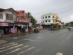
Padre Garcia, Batangas
| Padre Garcia | ||
|---|---|---|
| Municipality | ||
| Municipality of Padre Garcia | ||
 | ||
| ||
| Nickname(s): Cattle Trading Capital of the Philippines[1] | ||
 Map of Batangas with Padre Garcia highlighted | ||
.svg.png) Padre Garcia Location within the Philippines | ||
| Coordinates: 13°53′N 121°13′E / 13.88°N 121.22°ECoordinates: 13°53′N 121°13′E / 13.88°N 121.22°E | ||
| Country |
| |
| Region | Calabarzon (Region IV-A) | |
| Province | Batangas | |
| District | 4th District | |
| Founded | December 1, 1949 | |
| Barangays | 18 (see Barangays) | |
| Government [2] | ||
| • Type | Sangguniang Bayan | |
| • Mayor | Michael Angelo C. Rivera | |
| • Electorate | 28,018 voters (2016) | |
| Area [3] | ||
| • Total | 41.51 km2 (16.03 sq mi) | |
| Population (2015 census)[4] | ||
| • Total | 48,302 | |
| • Density | 1,200/km2 (3,000/sq mi) | |
| Time zone | UTC+8 (PST) | |
| ZIP code | 4224 | |
| PSGC | 041020000 | |
| IDD : area code | +63 (0)43 | |
| Climate type | Tropical monsoon climate | |
| Income class | 2nd municipal income class | |
| Revenue (₱) | 141,589,666.14 (2016) | |
| Native languages | Tagalog | |
| Website |
www | |

Padre Garcia, officially the Municipality of Padre Garcia, (Tagalog: Bayan ng Padre Garcia), is a 2nd class municipality in the province of Batangas, Philippines. According to the 2015 census, it has a population of 48,302 people.[4]
Padre Garcia's old name is Lumang Bayan, as it is the former seat of government of the neighboring town of Rosario. The name of the town is derived from one of its most famous sons, Padre Vicente Garcia, a native of Barangay Maugat. He was one of the first defenders of Jose Rizal's Noli Me Tangere. He and Rizal were friends during the time when they were fighting for the Philippine's independence from Spain.[5]
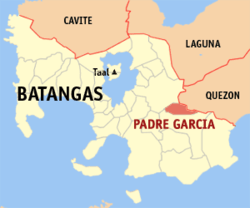
It is bounded on the north by Lipa City, east by San Antonio, south by Rosario and west by Lipa City and Rosario.
History
The town was originally part of Rosario and known as Lumang Bayan or Sambat. It became a separate municipality in 1949 through Executive Order 279 by President Elpidio Quirino,[6] with Jose A. Pesigan and Rustico K. Recto as first elected mayor and vice mayor respectively.
In 1952, the town council founded the cattle market or bakahan. This was in direct competition to the established livestock market of neighbouring Rosario, which resulted in rivalry, intimidation, and violence at times. But the market succeeded and developed into the biggest auction market in Southern Tagalog.[5]
Geography
Padre Garcia is located at 13°53′N 121°13′E / 13.88°N 121.22°E.
According to the Philippine Statistics Authority, the municipality has a land area of 41.51 square kilometres (16.03 sq mi) [3] constituting 1.33% of the 3,119.75-square-kilometre- (1,204.54 sq mi) total area of Batangas.
Barangays
Padre Garcia is politically subdivided into 18 barangays.[7]
| PSGC | Barangay | Population | ±% p.a. | |||
|---|---|---|---|---|---|---|
| 2015[4] | 2010[8] | |||||
| 041020001 | Banaba | 6.9% | 3,322 | 3,209 | 0.66% | |
| 041020002 | Banaybanay | 4.8% | 2,312 | 2,259 | 0.44% | |
| 041020014 | Bawi | 7.5% | 3,639 | 3,264 | 2.09% | |
| 041020015 | Bukal | 4.8% | 2,330 | 2,078 | 2.20% | |
| 041020016 | Castillo | 3.7% | 1,791 | 1,558 | 2.69% | |
| 041020017 | Cawongan | 7.3% | 3,544 | 3,162 | 2.20% | |
| 041020018 | Manggas | 2.4% | 1,176 | 1,056 | 2.07% | |
| 041020019 | Maugat East | 1.7% | 806 | 955 | −3.18% | |
| 041020020 | Maugat West | 4.3% | 2,059 | 1,915 | 1.39% | |
| 041020021 | Pansol | 9.6% | 4,660 | 4,343 | 1.35% | |
| 041020022 | Payapa | 6.4% | 3,071 | 2,590 | 3.30% | |
| 041020023 | Poblacion | 7.3% | 3,536 | 3,560 | −0.13% | |
| 041020024 | Quilo‑quilo North | 6.1% | 2,955 | 2,699 | 1.74% | |
| 041020025 | Quilo‑quilo South | 6.8% | 3,283 | 2,867 | 2.61% | |
| 041020026 | San Felipe | 8.3% | 4,022 | 3,798 | 1.10% | |
| 041020027 | San Miguel | 6.5% | 3,133 | 3,139 | −0.04% | |
| 041020028 | Tamak | 1.6% | 772 | 682 | 2.39% | |
| 041020029 | Tangob | 3.9% | 1,891 | 1,743 | 1.56% | |
| Total | 48,302 | 44,877 | 1.41% | |||
Demographics
| Population census of Padre Garcia | ||
|---|---|---|
| Year | Pop. | ±% p.a. |
| 1960 | 10,708 | — |
| 1970 | 15,498 | +3.76% |
| 1975 | 17,541 | +2.51% |
| 1980 | 19,591 | +2.23% |
| 1990 | 25,958 | +2.85% |
| 1995 | 28,959 | +2.07% |
| 2000 | 34,504 | +3.83% |
| 2007 | 42,942 | +3.06% |
| 2010 | 44,877 | +1.62% |
| 2015 | 48,302 | +1.41% |
| Source: Philippine Statistics Authority[4][8][9][10] | ||
In the 2015 census, Padre Garcia had a population of 48,302.[4] The population density was 1,200 inhabitants per square kilometre (3,100/sq mi).
References
- ↑ "House Bill No. 4154" (PDF). House of Representatives of the Philippines. Retrieved 10 December 2016.
- ↑ "Municipality". Quezon City, Philippines: Department of the Interior and Local Government. Retrieved 31 May 2013.
- 1 2 "Province: Batangas". PSGC Interactive. Quezon City, Philippines: Philippine Statistics Authority. Retrieved 12 November 2016.
- 1 2 3 4 5 Census of Population (2015). "Region IV-A (Calabarzon)". Total Population by Province, City, Municipality and Barangay. PSA. Retrieved 20 June 2016.
- 1 2 "Padre Garcia Livestock Auction Market". Municipality of Padre Garcia. Retrieved 12 November 2013.
- ↑ "Executive Order No. 279; Organizing Certain Barrios of the Municipality of Rosario, Province of Batangas, Into an Independent Municipality Under the Name of Padre Garcia". Official Gazette of the Republic of the Philippines. Malacañang, Manila, Philippines. 11 October 1949. Archived from the original on 12 October 2016. Retrieved 10 December 2016.
- ↑ "Municipal: Padre Garcia, Batangas". PSGC Interactive. Quezon City, Philippines: Philippine Statistics Authority. Retrieved 8 January 2016.
- 1 2 Census of Population and Housing (2010). "Region IV-A (Calabarzon)". Total Population by Province, City, Municipality and Barangay. NSO. Retrieved 29 June 2016.
- ↑ Censuses of Population (1903–2007). "Region IV-A (Calabarzon)". Table 1. Population Enumerated in Various Censuses by Province/Highly Urbanized City: 1903 to 2007. NSO.
- ↑ "Province of Batangas". Municipality Population Data. Local Water Utilities Administration Research Division. Retrieved 17 December 2016.
External links
| Wikimedia Commons has media related to Padre Garcia, Batangas. |
Places adjacent to Padre Garcia, Batangas | ||||||||||
|---|---|---|---|---|---|---|---|---|---|---|
| ||||||||||
Batangas (capital) | |
| Municipalities | |
| Component cities | |