O'Fallon, Missouri
| O'Fallon, Missouri | ||
|---|---|---|
| City | ||
 | ||
| ||
| Motto(s): Tradition with Vision | ||
 Location in the state of Missouri | ||
| Coordinates: 38°47′04″N 90°42′29″W / 38.78444°N 90.70806°WCoordinates: 38°47′04″N 90°42′29″W / 38.78444°N 90.70806°W | ||
| Country | United States | |
| State |
| |
| County | St. Charles | |
| Metro | Greater St. Louis | |
| First Settled | 1856 | |
| Incorporated | September 25, 1912 | |
| Government[1] | ||
| • Type | Mayor-council government | |
| • Mayor | Bill Hennessy | |
| • City Council |
List
| |
| Area[2] | ||
| • City | 29.20 sq mi (75.63 km2) | |
| • Land | 29.19 sq mi (75.60 km2) | |
| • Water | 0.01 sq mi (0.03 km2) | |
| Elevation[3] | 541 ft (165 m) | |
| Population (2010)[4] | ||
| • City | 79,329 | |
| • Estimate (2017)[5] | 87,597 | |
| • Density | 2,700/sq mi (1,000/km2) | |
| • Metro | 2,810,056 (US: 19th) | |
| Time zone | UTC−6 (CST) | |
| • Summer (DST) | UTC−5 (CDT) | |
| ZIP code | 63366, 63368 | |
| Area code(s) | 636 | |
| FIPS code | 29-54074 | |
| GNIS feature ID | 0756460[6] | |
| Website | http://www.ofallon.mo.us/ | |

O'Fallon /oʊˈfælən/ is a city along Interstate 70 and Interstate 64 between Lake St. Louis and St. Peters in St. Charles County, Missouri. It is part of the St. Louis Metropolitan Statistical Area. As of the 2010 census O'Fallon had a population of 79,329, making it the largest municipality in St. Charles County and seventh largest in the state of Missouri.[7] In 2006 Money Magazine named O'Fallon 39th in its "Best 100 Places to Live."[8] Money Magazine also ranked O'Fallon 68th out of 100 in 2008,[9] 26th out of 100 in 2010,[10] and 42nd out of 100 in 2017.[11]
O'Fallon's namesake in St. Clair County, Illinois is also part of the St. Louis Metropolitan Statistical Area. The two O'Fallons are one of the few pairs of same-named municipalities to be part of the same MSA.
History
O'Fallon was founded in 1856 by Nicholas Krekel.[12] The community was named after John O'Fallon the President of the North Missouri Railroad.[13] A post office called O'Fallon has been in operation since 1859.[14]
The St. Mary's Institute of O'Fallon was listed on the National Register of Historic Places in 2007.[15]
Geography
According to the United States Census Bureau, the city has a total area of 29.20 square miles (75.63 km2), of which, 29.19 square miles (75.60 km2) is land and 0.01 square miles (0.03 km2) is water.[2]
Demographics
| Historical population | |||
|---|---|---|---|
| Census | Pop. | %± | |
| 1880 | 295 | — | |
| 1920 | 588 | — | |
| 1930 | 594 | 1.0% | |
| 1940 | 618 | 4.0% | |
| 1950 | 789 | 27.7% | |
| 1960 | 3,770 | 377.8% | |
| 1970 | 7,018 | 86.2% | |
| 1980 | 8,677 | 23.6% | |
| 1990 | 18,698 | 115.5% | |
| 2000 | 46,169 | 146.9% | |
| 2010 | 79,329 | 71.8% | |
| Est. 2017 | 87,597 | [5] | 10.4% |
| U.S. Decennial Census[16] 2017 Estimate[5] | |||
2010 census
As of the census[4] of 2010, there were 79,329 people, 28,234 households, and 21,436 families residing in the city. The population density was 2,717.7 inhabitants per square mile (1,049.3/km2). There were 29,376 housing units at an average density of 1,006.4 per square mile (388.6/km2). The racial makeup of the city was 89.9% White, 4.0% African American, 0.2% Native American, 3.2% Asian, 0.1% Pacific Islander, 0.8% from other races, and 1.8% from two or more races. Hispanic or Latino of any race were 2.7% of the population.
There were 28,234 households of which 44.7% had children under the age of 18 living with them, 61.6% were married couples living together, 10.0% had a female householder with no husband present, 4.3% had a male householder with no wife present, and 24.1% were non-families. 19.3% of all households were made up of individuals and 6.2% had someone living alone who was 65 years of age or older. The average household size was 2.80 and the average family size was 3.23.
The median age in the city was 34.3 years. 30% of residents were under the age of 18; 7.1% were between the ages of 18 and 24; 30.8% were from 25 to 44; 23.1% were from 45 to 64; and 8.9% were 65 years of age or older. The gender makeup of the city was 48.8% male and 51.2% female.
Economy
Mastercard has a major presence in O'Fallon.
Venture Stores[17] was headquartered and maintained a distribution center in O'Fallon, until its dissolution. The buildings are now occupied by True Manufacturing.
Shell Oil Company announced on February 27, 2012 it will close its regional distribution center here by the end of 2012, costing more than a dozen jobs.[18]
Lou Fusz Automotive Dealership in O'Fallon, won the 2012 State of Missouri Bid Contract for Police vehicles for the second year in a row.[19]
Sports
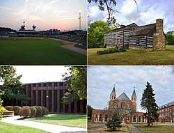
O'Fallon is the home of the River City Rascals independent Frontier League baseball team. The Rascals play at CarShield Field in O'Fallon, which was built in 1999. It is located on Tom Ginnever Boulevard and T.R. Hughes Boulevard near downtown.
Parks and recreation
- Civic Park - A 20 acres (81,000 m2) park featuring Alligator's Creek Aquatic Center, Bandstand and Amphitheater.
- Dames Park - A 59 acres (240,000 m2) sports park with three football fields and a fitness course.
- Fort Zumwalt Park - A 47.5 acres (192,000 m2) park featuring a fishing lake, a disc golf course, playgrounds and historic Fort Zumwalt.
- Knaust Park - A 6 acres (24,000 m2) park with a playground and walking path.
- O'Fallon Sports Park - A 95 acres (380,000 m2) soccer complex with 12 fields playgrounds and concessions. Also home to the Renaud Spirit Center.
- Ozzie Smith Sports Complex - A 76 acres (310,000 m2) baseball/softball complex with seven diamonds and the St. Charles Co. Amateur Sports Hall of Fame. Adjacent to CarShield Field.
- Westhoff Park - A 65 acres (260,000 m2) park featuring baseball diamonds, sand volleyball courts, horseshoe pits, basketball courts, tennis and handball courts, and a skate park.
Climate
| Climate data for O'Fallon, Missouri | |||||||||||||
|---|---|---|---|---|---|---|---|---|---|---|---|---|---|
| Month | Jan | Feb | Mar | Apr | May | Jun | Jul | Aug | Sep | Oct | Nov | Dec | Year |
| Record high °F (°C) | 76 (24) |
85 (29) |
88 (31) |
94 (34) |
92 (33) |
97 (36) |
105 (41) |
107 (42) |
102 (39) |
95 (35) |
85 (29) |
76 (24) |
107 (42) |
| Average high °F (°C) | 38 (3) |
45 (7) |
55 (13) |
66 (19) |
75 (24) |
83 (28) |
88 (31) |
87 (31) |
80 (27) |
69 (21) |
55 (13) |
42 (6) |
65 (19) |
| Average low °F (°C) | 18 (−8) |
24 (−4) |
33 (1) |
44 (7) |
54 (12) |
63 (17) |
68 (20) |
66 (19) |
58 (14) |
45 (7) |
35 (2) |
24 (−4) |
44 (7) |
| Record low °F (°C) | −23 (−31) |
−14 (−26) |
−11 (−24) |
18 (−8) |
26 (−3) |
39 (4) |
45 (7) |
36 (2) |
27 (−3) |
19 (−7) |
−5 (−21) |
−28 (−33) |
−28 (−33) |
| Average precipitation inches (mm) | 1.79 (45.5) |
2.26 (57.4) |
3.38 (85.9) |
3.58 (90.9) |
4.34 (110.2) |
3.62 (91.9) |
4.18 (106.2) |
3.13 (79.5) |
3.29 (83.6) |
3.10 (78.7) |
3.56 (90.4) |
2.41 (61.2) |
38.64 (981.5) |
| Source: [20] | |||||||||||||
Government
O'Fallon operates under a charter form of government. In 2010, the current four wards were redistricted and a new, fifth ward was created. The current mayor is William "Bill" Hennessy. The current (April 2017) City Council members are: Dave Hinman, Rick Lucas, Rose Mack, Tom Herweck, Reid Cranmer, Jeff Schwentker, Jeff Kuehn, Mike Pheney, and Debbie Cook. Laws
Proposition S
On April 5, 2011, 72% of O'Fallon voters approved of Proposition S, the "Smoke-Free O'Fallon" Ordinance. The ordinance became a law and went into effect on June 16, 2011. Under the new law, there is a ban on smoking in all places of employment and at indoor public events. Some examples of places of employment that are under the smoking ban include libraries, schools, bars, restaurants, stores, manufacturers and private clubs who either have employees or host public events. In addition to the smoking ban at places of employment, there should also be proper “No Smoking” signs posted at every entrance of places of employment, and no ashtray should be in the smoke-free areas at places of employment. There are some exclusions in the ordinance, including: private homes, 20% of hotel and motel rooms, outdoor events, and outdoor spaces more than 3 feet away from doorways, windows, and ventilation systems.[21]
Education
Satellite campuses of Webster University and Lindenwood University are located in O'Fallon. For public schools, O'Fallon is served mostly by the Fort Zumwalt School District, and the westernmost part is served by the Wentzville R-IV School District. The south to southeastern part of the city is served by the Francis Howell R-III School District. St. Dominic High School is a private Catholic school located in O'Fallon; Christian High School is a non-denominational Christian secondary school also located in O'Fallon.
Infrastructure
Fire Protection is mostly provided by the O'Fallon Fire Protection District which in 2007 became the first Internationally Accredited Fire Agency in the State of Missouri. The award was made by the Center for Public Safety Excellence's Commission on Fire Accreditation International (CFAI). The CFAI has approved accreditation status for only 120 fire agencies worldwide.
The Southern portion of the City is served by the Wentzville Fire Protection District.
Notable people
- Nathan Heald (September 24, 1775 – April 27, 1832), U.S. Army officer during the War of 1812, in command of Fort Dearborn, in Chicago
- Harry Gilmer (April 14, 1926 – August 20, 2016), All-American college and Pro-Bowl football player and former head coach of the Detroit Lions
References
- ↑ "O'Fallon Elected Officials". City of O'Fallon, Missouri. Retrieved 2009-04-24.
- 1 2 "US Gazetteer files 2010". United States Census Bureau. Archived from the original on 2012-07-14. Retrieved 2012-07-08.
- ↑ "Geographic Names Information System". United States Geological Survey. Retrieved 2008-01-31.
- 1 2 "American FactFinder". United States Census Bureau. Retrieved 2012-07-08.
- 1 2 3 "City and Town Population Totals: 2010-2017". Retrieved May 26, 2018.
- ↑ "US Board on Geographic Names". United States Geological Survey. 2007-10-25. Retrieved 2008-01-31.
- ↑ "Annual Estimates of the Population for Incorporated Places in Missouri". United States Census Bureau. Retrieved 2008-07-12.
- ↑ "100 Best Places to Live". Money Magazine. Retrieved 2010-07-30.
- ↑ "100 Best Places to Live". Money Magazine. Retrieved 2010-07-30.
- ↑ "100 Best Places to Live". Money Magazine. Retrieved 2010-07-30.
- ↑ "O'Fallon, Missouri is MONEY's No. 42 Best Place to Live in America". Money. Retrieved 2018-07-29.
- ↑ "St. Charles County Place Names, 1928–1945". The State Historical Society of Missouri. Archived from the original on June 24, 2016. Retrieved November 27, 2016.
- ↑ Eaton, David Wolfe (1918). How Missouri Counties, Towns and Streams Were Named. The State Historical Society of Missouri. p. 356.
- ↑ "Post Offices". Jim Forte Postal History. Retrieved 27 November 2016.
- ↑ National Park Service (2010-07-09). "National Register Information System". National Register of Historic Places. National Park Service.
- ↑ United States Census Bureau. "Census of Population and Housing". Retrieved January 31, 2014.
- ↑ "Welcome to Venture." Venture Stores. January 11, 1998. Retrieved on August 14, 2009.
- ↑ Shell to close operations in Ill., Mo. Archived 2012-03-01 at the Wayback Machine., St. Louis Post-Dispatch (February 27, 2012)
- ↑ Awarding of State of Missouri Police Vehicle Bid Contract
- ↑ "Average Weather for O'Fallon, MO - Temperature and Precipitation". Weather.com. Retrieved August 27, 2010.
- ↑ "Archived copy". Archived from the original on 2012-04-07. Retrieved 2011-09-27.
External links
- City of O'Fallon
- O'Fallon Fire Protection District
- St. Charles City-County Library District
- O'Fallon MO Live Weather
- Historic maps of O'Fallon in the Sanborn Maps of Missouri Collection at the University of Missouri
| Topics |  | |
|---|---|---|
| Central city | ||
| Largest cities (over 50,000 in 2010) | ||
| Medium-sized cities (over 20,000 in 2010) | ||
| Largest towns and villages (over 10,000 in 2010) |
| |
| Missouri Counties | ||
| Illinois Counties | ||
| Subregions | ||
Municipalities and communities of St. Charles County, Missouri, United States | ||
|---|---|---|
| Cities | 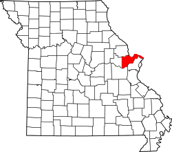 | |
| Villages | ||
| Townships |
| |
| CDP | ||
| Other unincorporated communities | ||
| Ghost towns | ||
| Footnotes | ‡This populated place also has portions in an adjacent county or counties | |
