Nelaug (lake)
| Nelaug | |
|---|---|
 Nelaug Location of the lake  Nelaug Nelaug (Norway) | |
| Location | Froland and Åmli |
| Coordinates | 58°40′16″N 08°34′10″E / 58.67111°N 8.56944°ECoordinates: 58°40′16″N 08°34′10″E / 58.67111°N 8.56944°E |
| Type | Reservoir |
| Primary inflows | Nidelva |
| Primary outflows | Nidelva |
| Basin countries | Norway |
| Max. length | 8 kilometres (5.0 mi) |
| Max. width | 3 kilometres (1.9 mi) |
| Surface area | 10 km2 (3.9 sq mi) |
| Shore length1 | 68 kilometres (42 mi) |
| Surface elevation | 138 metres (453 ft) |
| References | NVE |
| 1 Shore length is not a well-defined measure. | |
Nelaug is a lake in the municipalities of Froland and Åmli in Aust-Agder county, Norway. The 10 kilometres (6.2 mi) lake is formed by a dam which regulates a hydroelectric power plant on the Nidelva river. The village of Nelaug is located near the dam in Froland municipality. The lake is located about 11 kilometres (6.8 mi) south of the village of Åmli, about 15 kilometres (9.3 mi) southeast of the village of Dølemo, and about 20 kilometres (12 mi) north of Blakstad.[1]
Name
The Old Norse form of the name must have been Niðlaug. The first element Nið is the old name of the river Nidelva and the last element is laug which means "lake".[1]
Media gallery
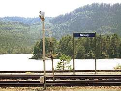 View of the lake near Nelaug Station
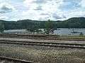 View of the lake near Nelaug Station
See also
References
- 1 2 Thorsnæs, Geir, ed. (2015-07-15). "Nelaug – innsjø". Store norske leksikon (in Norwegian). Kunnskapsforlaget. Retrieved 2017-12-09.
This article is issued from
Wikipedia.
The text is licensed under Creative Commons - Attribution - Sharealike.
Additional terms may apply for the media files.