Arstaddalsdammen
| Arstaddalsdammen | |
|---|---|
 | |
| Location | Beiarn, Nordland |
| Coordinates | 66°53′48″N 14°22′58″E / 66.89667°N 14.38278°E / 66.89667; 14.38278Coordinates: 66°53′48″N 14°22′58″E / 66.89667°N 14.38278°E / 66.89667; 14.38278 |
| Basin countries | Norway |
| Built | 1960s |
| Max. length | 4.5 kilometres (2.8 mi) |
| Max. width | 1 kilometre (0.62 mi) |
| Surface area | 2.54 km2 (0.98 sq mi) |
| Shore length1 | 9.66 kilometres (6.00 mi) |
| Surface elevation | 340 metres (1,120 ft) |
| References | NVE |
| 1 Shore length is not a well-defined measure. | |
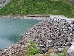
Arstaddalsdammen is a lake that lies in the municipality of Beiarn in Nordland county, Norway. It is located about 15 kilometres (9.3 mi) southwest of the village of Moldjord. The 2.54-square-kilometre (0.98 sq mi) lake lies in the southern end of the Arstaddal valley, and it has a dam on the northern end. The dam was built in the 1960s. The water from the lake is piped to the nearby lake Sokumvatnet in Gildeskål.[1] The lake serves as a reservoir for the Sundsfjord Hydroelectric Power Station.[2]
See also
References
- ↑ "Arstaddalsdammen" (in Norwegian). yr.no. Retrieved 2012-03-22.
- ↑ SKS produksjon: Sundsfjord.
This article is issued from
Wikipedia.
The text is licensed under Creative Commons - Attribution - Sharealike.
Additional terms may apply for the media files.