Rekvatnet
| Rekvatnet Goajvojávrre | |
|---|---|
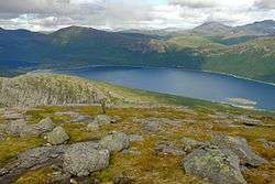 Rekvatnet in Hamarøy seen from Kråkmotinden | |
| Location | Hamarøy, Nordland |
| Coordinates | 67°48′32″N 16°04′54″E / 67.8088°N 16.0817°E / 67.8088; 16.0817Coordinates: 67°48′32″N 16°04′54″E / 67.8088°N 16.0817°E / 67.8088; 16.0817 |
| Basin countries | Norway |
| Max. length | 4.8 kilometres (3.0 mi) |
| Max. width | 3.5 kilometres (2.2 mi) |
| Surface area | 7.41 km2 (2.86 sq mi) |
| Shore length1 | 13.8 kilometres (8.6 mi) |
| Surface elevation | 284 metres (932 ft) |
| References | NVE |
| 1 Shore length is not a well-defined measure. | |
Rekvatnet (Lule Sami: Goajvojávrre) is a lake in the municipality of Hamarøy in Nordland county, Norway. The lake lies about 15 kilometres (9.3 mi) southeast of the village of Tømmerneset. The lake Šluŋkkajávri lies just to the east of the lake. The water from Rekvatnet is piped downhill to a hydroelectric power station on the shores of the lake nearby, Lake Fjerdvatnet.[1]
See also
References
- ↑ Store norske leksikon. "Rekvatnet" (in Norwegian). Retrieved 2012-05-02.
This article is issued from
Wikipedia.
The text is licensed under Creative Commons - Attribution - Sharealike.
Additional terms may apply for the media files.