Grasvatnet
| Grasvatnet / Gresvatnet Graesiejaevrie | |
|---|---|
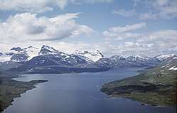 Grasvatnet and Oksskolten mountains in the background. | |
| Location | Hemnes, Norway and Västerbotten, Sweden |
| Coordinates | 66°03′59″N 14°26′22″E / 66.06639°N 14.43944°ECoordinates: 66°03′59″N 14°26′22″E / 66.06639°N 14.43944°E |
| Basin countries | Norway and Sweden |
| Max. length | 11 kilometres (6.8 mi) |
| Max. width | 4.5 kilometres (2.8 mi) |
| Surface area |
22.63 km2 (8.74 sq mi) (18.67 km2 or 7.21 sq mi in Norway) |
| Shore length1 | 44.09 kilometres (27.40 mi) |
| Surface elevation | 595 metres (1,952 ft) |
| References | NVE |
| 1 Shore length is not a well-defined measure. | |
Gresvatnet or Grasvatnet (Southern Sami: Graesiejaevrie) is a lake on the border between Norway and Sweden. Most of the lake lies in the municipality of Hemnes in Nordland county (Norway) and then a small portion crosses the border into Storuman Municipality in Västerbotten county (Sweden). The lake lies about 25 kilometres (16 mi) east of the village of Korgen, and just a few kilometres northeast of the mountain Oksskolten and the Okstindbreen glacier.[1]
See also
References
- ↑ Store norske leksikon. "Grasvatnet" (in Norwegian). Retrieved 2011-12-05.
This article is issued from
Wikipedia.
The text is licensed under Creative Commons - Attribution - Sharealike.
Additional terms may apply for the media files.