Vangsmjøse
| Vangsmjøse | |
|---|---|
 | |
| Location | Vang, Oppland, Norway |
| Coordinates | 61°09′46″N 08°26′30″E / 61.16278°N 8.44167°E / 61.16278; 8.44167Coordinates: 61°09′46″N 08°26′30″E / 61.16278°N 8.44167°E / 61.16278; 8.44167 |
| Basin countries | Norway |
| Surface area | 18.25 km2 (7.05 sq mi) |
| Shore length1 | 43.47 km (27.01 mi) |
| Surface elevation | 466 m (1,529 ft) |
| References | NVE |
| 1 Shore length is not a well-defined measure. | |
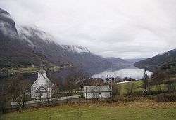
Vangsmjøse (Vangsmjøsa or Vangsmjøsi) is a lake in Vang municipality in Oppland county, Norway. It has an area of 18.25 km² and is about 154 m deep according to NVE. A local myth says that if you lower a raw ham in the deepest part of Vangsmjøse, it will be boiled when you pull it up again. It is at an elevation of 466 m above sea level. The shoreline is 43.47 km around.
Øye stave church (Øye stavkyrkje) is situated in Øye, a village at the west end of Vangsmjøse. The scenic European route E16 runs through Øye and along the south shore of Vangsmjøse.
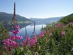
Other view of Vangsmjøse
See also
External links
This article is issued from
Wikipedia.
The text is licensed under Creative Commons - Attribution - Sharealike.
Additional terms may apply for the media files.