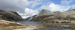
Rondvatnet
| Rondvatnet | |
|---|---|
 seen by the cabin Rondvassbu. | |
| Location | Rondane |
| Coordinates | 61°53′59″N 9°48′6″E / 61.89972°N 9.80167°E / 61.89972; 9.80167Coordinates: 61°53′59″N 9°48′6″E / 61.89972°N 9.80167°E / 61.89972; 9.80167 |
| Basin countries | Norway |
| Max. length | 3.7 km (2.3 mi) |
| Surface area | 95.56 ha (240 acres)[1] |
| Surface elevation | 1,167 m (3,829 ft) |
| References | [1] |
Rondvatnet is a narrow lake in Rondane National Park. By the southern end is the Norwegian Mountain Touring Association's cabin Rondvassbu. Rondvatnet separates the eastern part of Rondane from the western part, Smiubelgen.
In the summer season there is a boat service on the lake transporting hikers between the southern and northern end.
The name
See Rondane
References
This article is issued from
Wikipedia.
The text is licensed under Creative Commons - Attribution - Sharealike.
Additional terms may apply for the media files.