Nisser
| Nisser | |
|---|---|
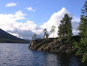 At the shore of Nisser | |
 Nisser Location of the lake  Nisser Nisser (Norway) | |
| Location | Nissedal, Telemark |
| Coordinates | 59°19′03″N 8°27′43″E / 59.3175°N 8.461944°ECoordinates: 59°19′03″N 8°27′43″E / 59.3175°N 8.461944°E |
| Primary inflows | Vråvatn |
| Primary outflows | Nisserelva |
| Basin countries | Norway |
| Surface area | 76.3 km2 (29.5 sq mi) |
| Max. depth | 234 m (768 ft) |
| Water volume | 7.19 km3 (5,830,000 acre⋅ft) |
| Surface elevation | 246 m (807 ft) |
Nisser is a lake in Nissedal, Norway. It is the 13th-largest lake in the nation by area with a surface area of 76.30 km², the 10th largest by volume at 7.19 km³, and the 13th deepest at 234 m. It is located in Nissedal and Kviteseid municipality[1] in Telemark county, and is Telemark’s largest lake.[2] Part of the Arendal watershed, water enters from the discharge of Vråvatn, and its outlet is the Nisserelva river.
In 1914, a canal was constructed between Nisser (which is 246 m above sea level) and Vråvatn (which is 248 m above sea level). This makes it possible to travel the 50 km long stretch from Tveitsund to Vråliosen by boat.
The Norse form of the name was Nizir - probably from an older form *Niðsær. The meaning of the name is 'the lake (sær) of the river Nið (now Nidelva (Aust-Agder))'.
See also
References
- ↑ Nisser (in Norwegian) Store Norske Leksikon, retrieved 28 August 2013
- ↑ Jan Erik Nilsen: Nissedal (in Norwegian) Store Norske Leksikon, retrieved 28 August 2013